




- My Forums
- Tiger Rant
- LSU Recruiting
- SEC Rant
- Saints Talk
- Pelicans Talk
- More Sports Board
- Fantasy Sports
- Golf Board
- Soccer Board
- O-T Lounge
- Tech Board
- Home/Garden Board
- Outdoor Board
- Health/Fitness Board
- Movie/TV Board
- Book Board
- Music Board
- Political Talk
- Money Talk
- Fark Board
- Gaming Board
- Travel Board
- Food/Drink Board
- Ticket Exchange
- TD Help Board
Customize My Forums- View All Forums
- Show Left Links
- Topic Sort Options
- Trending Topics
- Recent Topics
- Active Topics
Started By
Message

Calling rds dc and other weather experts: Tornado outbreak next Monday - Tuesday?
Posted on 11/2/18 at 7:20 am


Posted on 11/2/18 at 7:20 am
LINK
Start us an informative thread about this potential.
TIA
Start us an informative thread about this potential.
TIA
quote:
...DISCUSSION... Potential exists for a significant severe event to transpire day 4 (Monday) into day 5 (Tuesday) mainly from the lower MS Valley into the Southeast States. Model solutions have converged and demonstrated run to run consistency, depicting significant cyclogenesis to commence by Monday evening over the lower MS Valley in response to an approaching intense upper jet within base of an amplifying shortwave trough. The low is forecast to deepen as it lifts northeast into IL overnight with trailing cold front advancing through the TN and lower MS valley regions. Richer low-level moisture residing over the northern Gulf will advect rapidly northward through the warm sector in response to the strengthening low-level jet, contributing to destabilization with moderate instability possible from east TX into a portion of the Gulf Coast states. Severe storms are likely to develop along advancing cold front Monday afternoon initially from southeast OK into east TX, then spreading into the lower MS Valley and TN Valley regions Monday night. Impressive wind profiles with large hodographs and an intense upper jet will promote a threat for damaging wind, tornadoes and large hail. Severe threat will continue east through portions of the Southeast states and Middle Atlantic Tuesday.
 6
6


Posted on 11/2/18 at 7:22 am to East Coast Band
The weather folks here in Houston expect some rain but nothing severe. The futurecast almost looked like it dissipated a bit as it got to New Orleans. I am unsure what area you are concerned with though.
Posted on 11/2/18 at 7:23 am to East Coast Band
I know Wednesday night sucked. Not looking forward to more weather like that.
Posted on 11/2/18 at 7:27 am to bigberg2000
My power still isn't back on from weds storm. I hope this next ones chills the frick out.
This post was edited on 11/2/18 at 7:28 am

Posted on 11/2/18 at 7:34 am to East Coast Band
This looks like it could be a very significant severe weather event for parts of the southeast. Maybe one of the more significant fall severe weather events we’ve had in the last few years. But, it’s still too early to be very specific.
This is from the National Weather Service office in Birmingham:
This is from the National Weather Service office in Birmingham:
quote:
The shortwave on Sunday night will serve as a primer wave for the next system developing to our west on Monday. A wide area of rich moisture will be lurking near the Gulf Coast, poised to move inland Monday afternoon and evening as wind fields respond to a shortwave entering the Southern Plains. Models are coming into agreement on a potentially dangerous setup Monday night into Tuesday morning across a large area which includes Alabama. The GFS and ECMWF are in good agreement with the evolution of the synoptic pattern, showing a low-amplitude shortwave taking on a negative tilt Monday night to our northwest. This pattern has the look of a classic severe weather outbreak and would support a rapidly deepening surface low tracking toward the Great Lakes with significant pressure falls extending southward into Alabama. With dewpoints rising into the upper 60s to perhaps 70F, instability appears more than sufficient for deep convection within a very highly sheared environment. Taken at face value, the ECMWF shows semi-discrete supercells capable of producing long-track, significant tornadoes across the northern half of our forecast area on Tuesday morning. The HWO will be updated to include a moderate confidence threat for tornadoes and damaging winds across the entire forecast area. With this threat still around 96 hours out and models subject to change, we will refrain from going all in on the potential for a tornado outbreak.
This post was edited on 11/2/18 at 7:38 am

Posted on 11/2/18 at 8:18 am to Roll Tide Ravens
I'm sure rds will have some sort of thread up by Sunday if the models keep going this direction. SPC currently has North Louisiana and Mississippi pegged for the Tuesday threat next week. Birmingham NWS is plenty experienced with tornado events, so if they're concerned I'd be concerned too.
Posted on 11/2/18 at 8:24 am to Roll Tide Ravens
quote:
This looks like it could be a very significant severe weather event for parts of the southeast.
Day 4 30% is pretty strong coming from SPC.
Posted on 11/2/18 at 8:41 am to Chuker
Idk like I said at least here in Houston they don’t expect a whole lot.


Posted on 11/2/18 at 8:43 am to rds dc
Is this a little abnormal? I know winter tornado outbreaks in the SE are becoming a near yearly occurrence, but this is early for that, isn't it?


Posted on 11/2/18 at 8:44 am to Pettifogger
This is normal severe weather season in south i though


Posted on 11/2/18 at 8:45 am to Duke
quote:
SPC currently has North Louisiana
Wonderful. Ugh.
Posted on 11/2/18 at 8:51 am to Pettifogger
quote:
Is this a little abnormal? I know winter tornado outbreaks in the SE are becoming a near yearly occurrence, but this is early for that, isn't it?
We get a "second" tornado season in the deep south as the weather changes but it seems a little more juiced with the budding El Nino bringing a little extra energy in the subtropical jet.
Posted on 11/2/18 at 9:59 am to Pettifogger
quote:
Is this a little abnormal? I know winter tornado outbreaks in the SE are becoming a near yearly occurrence, but this is early for that, isn't it?
No, we are now into the fall-winter tornado season. It's the early part of the season, but we are in it.
Posted on 11/2/18 at 10:42 am to Roll Tide Ravens
as I posted in the other tornado thread when they started talking about this new threat...


Posted on 11/2/18 at 10:44 am to Pettifogger
quote:
Is this a little abnormal?
It might be a little early this year and it isn't talked about much but there is a tornado / severe weather season that takes place around thanksgiving every year.
Posted on 11/2/18 at 12:11 pm to East Coast Band
RDS touched on this event a few days ago in the other storm thread early Thursday am. Will be interesting to watch. I'm guessing it gathers strength and steam after TX.
Posted on 11/2/18 at 12:29 pm to Roll Tide Ravens
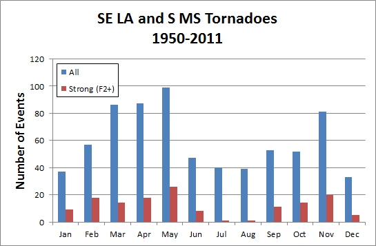
I found this chart. It's a little old and I think Alabama and other southern states are in line with this chart

Posted on 11/2/18 at 12:32 pm to East Coast Band
quote:
Calling rds dc

quote:
other weather experts

This post was edited on 11/2/18 at 12:36 pm
Posted on 11/2/18 at 12:39 pm to Ponchy Tiger
quote:
It might be a little early this year and it isn't talked about much but there is a tornado / severe weather season that takes place around thanksgiving every year.
You can say that again. I suspect y’all are part of a plot to convince people that the fall/early winter is a severe storm/tornado season for the south.
Never heard of this before, and never remember this season being particularly bad.
So who’s paying you? Soros?
Posted on 11/2/18 at 2:05 pm to East Coast Band
It’s just rain calm the F down.

 Page 1 of 2

Popular
Back to top
 Follow TigerDroppings for LSU Football News