- My Forums
- Tiger Rant
- LSU Recruiting
- SEC Rant
- Saints Talk
- Pelicans Talk
- More Sports Board
- Fantasy Sports
- Golf Board
- Soccer Board
- O-T Lounge
- Tech Board
- Home/Garden Board
- Outdoor Board
- Health/Fitness Board
- Movie/TV Board
- Book Board
- Music Board
- Political Talk
- Money Talk
- Fark Board
- Gaming Board
- Travel Board
- Food/Drink Board
- Ticket Exchange
- TD Help Board
Customize My Forums- View All Forums
- Show Left Links
- Topic Sort Options
- Trending Topics
- Recent Topics
- Active Topics
Started By
Message
re: Hurricane Season - August - Potential Tropical Cyclone #9
Posted on 8/3/17 at 3:00 pm to rds dc
Posted on 8/3/17 at 3:00 pm to rds dc
But front/trophs do protect the SEConUS and eastern seaboard with regularity, which I see happening here. Storms recurve out to sea way more often than not, except of course the old 'home brews' that form in the gulf and western Caribbean. When those form they have a better chance of hitting land. The CV long trackers are re-directed out to sea routinely by fronts. So in my opinion its a good thing the pattern has changed just in time for the season to ramp up.
 0
0

Posted on 8/3/17 at 3:04 pm to LSUTigersVCURams
quote:Agreed.
quote:Gonna be interesting watching the storm out by Africa. Probably going out to sea
Posted on 8/3/17 at 4:14 pm to rds dc
Thursday Afternoon: August 3, 2017.
18Z : 1 pm CDT : INVEST 90L
12.2 N 65.8 W MOVG W 12 KT
Max winds in convection ~30-35KT
Pressure 1011 millibars.
18Z : 1 pm CDT : INVEST 90L
12.2 N 65.8 W MOVG W 12 KT
Max winds in convection ~30-35KT
Pressure 1011 millibars.
Posted on 8/3/17 at 4:22 pm to rds dc
Shouldn't all the early cool fronts keep 90L from coming North?
Posted on 8/3/17 at 4:35 pm to MLSter

this pic freaks me out and makes me laugh at the same time
Posted on 8/3/17 at 4:36 pm to bharris4qb1
quote:
Whats the timeline on it getting to our side of the globe if it makes it that far?
Probably a week give or take to reach the islands. Euro is weaker and faster while the GFS is stronger and slower. At this point, not too worried about 99L.
Posted on 8/3/17 at 4:41 pm to Midtiger farm
quote:
Shouldn't all the early cool fronts keep 90L from coming North?
The opposite, the same mechanism that drives these fronts southward also creates a weakness that could allow a system to move northward. However, timing is key and we know little beyond that there is potential for a system to be in the SW Gulf in 5 or so days.

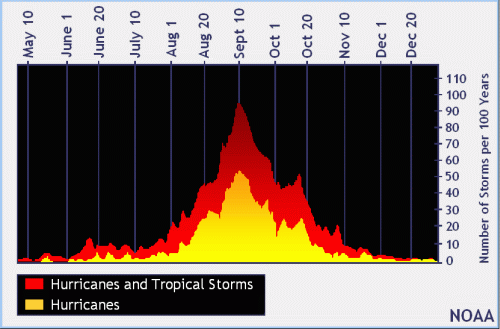
Posted on 8/3/17 at 5:24 pm to rds dc
See that peak?
Some dumbass at my company decided it would be a great idea to host a national sales meeting (600+ people attending) in Fort Lauderdale starting Sept. 10th - 15th.
The same dumbass scheduled a meeting for 350+ to attend a meeting in New York back in March the week it was hit with a blizzard of 12+ inches of snow. Of course, it was cancelled.
Can't wait for the inevitable notice of cancellation.
Posted on 8/3/17 at 8:58 pm to HubbaBubba
GFS and Canadian really like 99L. Euro never really develops it but has 90L as a strong TS/Weak Cat 1 in W Gulf.


Posted on 8/3/17 at 9:26 pm to MLSter
quote:
I'll be in the keys next week, will this screw my trip up?
Key West, Key Largo, Islamorada, Disney Island chances?
Posted on 8/3/17 at 10:26 pm to rds dc
NHC has bumped 90L up to 40% and the 18z GEFS has more tracks than previous runs

Posted on 8/3/17 at 11:23 pm to rds dc
The HWRF doing HWRF things with 99L

Posted on 8/3/17 at 11:42 pm to rds dc
And the GFS is down to 925...


Posted on 8/4/17 at 5:31 am to rds dc
Posted on 8/4/17 at 6:18 am to rds dc
Yeah 925 mb....

Posted on 8/4/17 at 6:55 am to PhillyTiger90
Tropical Weather Outlook
NWS National Hurricane Center Miami FL
800 AM EDT Fri Aug 4 2017
For the North Atlantic...Caribbean Sea and the Gulf of Mexico:
1. A broad low pressure system, associated with a tropical wave, is
producing a large area of disorganized showers and thunderstorms
several hundred miles south and southwest of the Cabo Verde
Islands. Environmental conditions are conducive for this system to
consolidate and develop during the next few days, and a tropical
depression is likely to form by early next week while moving
west-northwestward at about 15 mph across the tropical Atlantic
Ocean.
* Formation chance through 48 hours...medium...50 percent.
* Formation chance through 5 days...high...80 percent.
2. A large area of cloudiness and thunderstorms located over the
central and eastern Caribbean Sea is associated with a tropical
wave. This disturbance is expected to move west-northwestward at
about 15 mph across the western Caribbean Sea and Bay of Campeche
through the middle of next week, where environmental conditions
appear conducive for development.
* Formation chance through 48 hours...low...20 percent.
* Formation chance through 5 days...medium...60 percent.
Forecaster Berg
Posted on 8/4/17 at 7:04 am to rds dc
Thanks for the updates, really appreciate them!

Posted on 8/4/17 at 11:56 am to Mudminnow
The latest 12z GFS run....


Posted on 8/4/17 at 11:59 am to rds dc
Cool, now they'll call up the National Guard a whole week in advance instead of a couple days over nothing.

 Page 2 of 8

Popular
Back to top