- My Forums
- Tiger Rant
- LSU Recruiting
- SEC Rant
- Saints Talk
- Pelicans Talk
- More Sports Board
- Fantasy Sports
- Golf Board
- Soccer Board
- O-T Lounge
- Tech Board
- Home/Garden Board
- Outdoor Board
- Health/Fitness Board
- Movie/TV Board
- Book Board
- Music Board
- Political Talk
- Money Talk
- Fark Board
- Gaming Board
- Travel Board
- Food/Drink Board
- Ticket Exchange
- TD Help Board
Customize My Forums- View All Forums
- Show Left Links
- Topic Sort Options
- Trending Topics
- Recent Topics
- Active Topics
Started By
Message
 I
I 5
5

Posted on 6/19/17 at 4:02 pm to rds dc
Well, that's a shitty projected path. Great. 
Hoping this thing speeds up because faster it's out of here less rain we going to get.
Hoping this thing speeds up because faster it's out of here less rain we going to get.
This post was edited on 6/19/17 at 4:03 pm
Posted on 6/19/17 at 4:03 pm to rds dc
Both the 12z HWRF and GFDL bring this in around the mouth of the river


This post was edited on 6/19/17 at 4:04 pm

Posted on 6/19/17 at 4:03 pm to rds dc
Rainfall potentials for BR area?
Posted on 6/19/17 at 4:04 pm to rds dc
quote:
rds dc
so what are looking at?
should BR be worried of flooding?

Posted on 6/19/17 at 4:04 pm to rds dc
Has the NHC ever issued a warning cone like that, and actual tropical storm warnings, for something that's not even officially deemed a depression yet? I can't recall seeing it.
Posted on 6/19/17 at 4:05 pm to rds dc
So does that mean more rain or less rain for Baton Rouge?
Posted on 6/19/17 at 4:05 pm to upgrayedd
If it continues to track east like the last model at the last moment, thats good for BR. We want to be on that western side.
Posted on 6/19/17 at 4:06 pm to Y.A. Tittle
It's new this year.
Posted on 6/19/17 at 4:06 pm to Y.A. Tittle
quote:
Has the NHC ever issued a warning cone like that, and actual tropical storm warnings, for something that's not even officially deemed a depression yet? I can't recall seeing it.
Before PTC2 (now Bret) today, no they hadn't done it. The "potential tropical cyclone" designation, which this year is being used for the first time, now allows them to make those types of advisories without it being a named system.
Posted on 6/19/17 at 4:06 pm to Y.A. Tittle
quote:
Has the NHC ever issued a warning cone like that, and actual tropical storm warnings, for something that's not even officially deemed a depression yet? I can't recall seeing it.
First time. This year, they're using the terminology "Potential Tropical Cyclone" to indicate basically an invest that's going to affect land and have a significant impact. It also allows them to use projected paths, watches/warnings, etc. without actually naming a system.
Posted on 6/19/17 at 4:07 pm to Y.A. Tittle
quote:
Has the NHC ever issued a warning cone like that, and actual tropical storm warnings, for something that's not even officially deemed a depression yet? I can't recall seeing it.
This is the 1st year doing it. I understand why they are doing it but the "potential tropical cyclone three" seems a bit awkward to me.
Posted on 6/19/17 at 4:12 pm to LSUvegasbombed
quote:
so what are looking at?
should BR be worried of flooding?
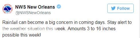
Be prepared and follow the local NWS. Unfortunately, the NWS New Orleans is spot on. However, it appears that heaviest totals should stay east of BR but no guarantees.

Posted on 6/19/17 at 4:16 pm to GEAUXmedic
quote:
They better dust off Bob Breck's toupee and get him on TV.
Nah, just put PJ on tv with his one track to Mobile
Posted on 6/19/17 at 4:20 pm to Midtiger farm
quote:
This is ridiculous for them to even have these models this far out. They can barely predict the weather correctly for tomorrow.
The storm is supposed to get here the day after tomorrow. It's not like it's a month out

Posted on 6/19/17 at 4:23 pm to rds dc
quote:
Potential TS Cindy
Based on the Cindy's I've known, we're all gonna die.
Posted on 6/19/17 at 4:25 pm to bayourougebengal
Rainfall will be the big issue with PTC3, but here are the arrival times for TS winds...

This post was edited on 6/19/17 at 4:27 pm

Posted on 6/19/17 at 4:26 pm to NorthEndZone
Wonderful 

Posted on 6/19/17 at 4:26 pm to bayourougebengal
HRRR is short range (only goes out 18 hours), but here it is. I think it is honestly a little fast with the system.

This post was edited on 6/19/17 at 4:28 pm
Posted on 6/19/17 at 4:28 pm to Roll Tide Ravens
HRRR isn't really made for tropical systems so the timing is probably off

 Page 31 of 105

Popular
Back to top