- My Forums
- Tiger Rant
- LSU Recruiting
- SEC Rant
- Saints Talk
- Pelicans Talk
- More Sports Board
- Fantasy Sports
- Golf Board
- Soccer Board
- O-T Lounge
- Tech Board
- Home/Garden Board
- Outdoor Board
- Health/Fitness Board
- Movie/TV Board
- Book Board
- Music Board
- Political Talk
- Money Talk
- Fark Board
- Gaming Board
- Travel Board
- Food/Drink Board
- Ticket Exchange
- TD Help Board
Customize My Forums- View All Forums
- Show Left Links
- Topic Sort Options
- Trending Topics
- Recent Topics
- Active Topics
Started By
Message
re: Hurricane/Tropical Storm Idalia Discussion Thread
Posted on 8/28/23 at 12:42 pm to joshnorris14
Posted on 8/28/23 at 12:42 pm to joshnorris14
quote:
HAFS-B 12z has this pushing as a borderline Cat 5 (926 mb) at landfall
This is the high end of my intensity range.
 2
2


Posted on 8/28/23 at 12:43 pm to rds dc
Not smart enough to know what the hayull I’m doing on tidbits

Posted on 8/28/23 at 12:43 pm to Athis
quote:
I was just looking at tidbits. They have that thing hitting Florida.. entering the Atlantic... then circling back.. crossing Florida and re-entering the Gulf... Then heading straight to New Orleans for Sept. 6th
Man that’s going to cause a huge problem with the other major hurricane hitting 3 days later that the women tracking their weather on Facebook keep sharing
They may even combine to become a category 8 supercane

Posted on 8/28/23 at 12:44 pm to crimsonsaint
quote:
It is where the NHC is located.
NHC says the next intermediate advisory is at 1:00 PM CDT.
Reminder for everyone that we don’t get a true new cone with the intermediate advisory. They just update the measurements and position.

Posted on 8/28/23 at 12:44 pm to Roll Tide Ravens
What do we think the chances are of a flight from Charleston to Orlando happening at noon on Thursday? Going to need to see the Tigers beat FSU.
Posted on 8/28/23 at 12:47 pm to Roll Tide Ravens
Here is what Idalia currently looks like from the closest Cuban radar site.


Posted on 8/28/23 at 12:47 pm to ThePoo
quote:
They may even combine to become a category 8 supercane
Holy frick! One of those could pick up sharks and the other pick up gators, leading to shark-gatornados, or shartornados, spinning off!!!
Posted on 8/28/23 at 12:48 pm to Roll Tide Ravens
Man western Cuba has been getting hammered for days now

Posted on 8/28/23 at 12:50 pm to Wolfhound45
quote:
Here we go again brother
Dude, I am on vacation in Amelia Island and the damn thing if tracking me here. LOL
Im hoping it will stay north of Tampa bay. I did no prep when we left last week. I have no idea what to do and when to do it so I dont think it will do me any good to leave. Just gonna pull up a chair here and watch the show
Posted on 8/28/23 at 12:52 pm to Roll Tide Ravens
Slowly creeping up.

Posted on 8/28/23 at 12:57 pm to trussthetruzz
quote:
What model and run were you looking at? 12z gfs shows that but it’s a weak depression that barely clips the coast. Would be a nothingburger
That's the one I am looking at.. I realize now that my comment might have raised some concerns.. I apologize didn't mean that..

Posted on 8/28/23 at 12:59 pm to LanierSpots
We moved into a new house in Parrish. Mrs 45 has been doing a lot of prepping. I went several months ago and got the stuff I need. We are set. Hopefully we do not get popped again this year 
Posted on 8/28/23 at 12:59 pm to Duke
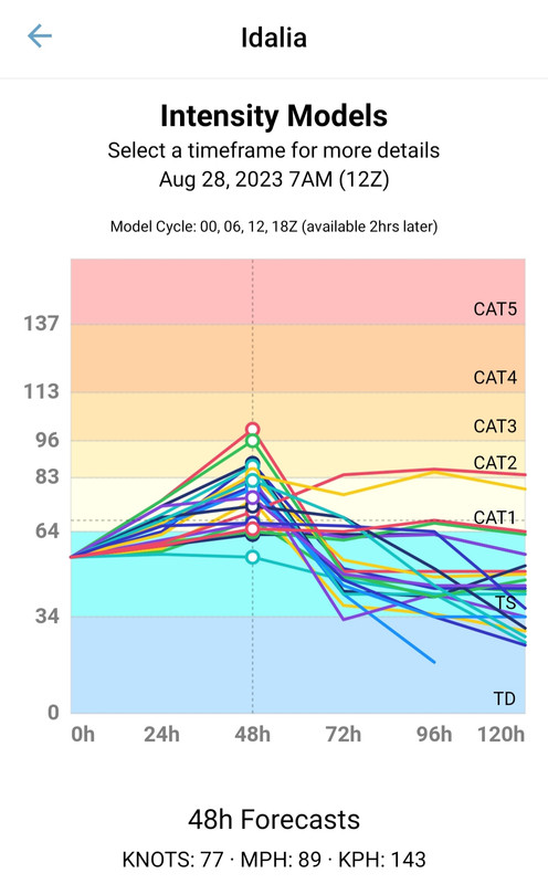
Lowest pressure and wind of the hurricane (H) models recent runs initialized at 12Z:
HWRF - 931.3 mb and 113.7 kt or 130 mph
HMON - 952.7 mb and 95.1 kt or 110 mph
HAFS-A - 950.8 mb and 98.4 kt or 115 mph
HAFS-B - 925.7 mb and 112.5 kt or 130 mph
All have landfall over or just east of Apalachee Bay.
HWRF - 931.3 mb and 113.7 kt or 130 mph
HMON - 952.7 mb and 95.1 kt or 110 mph
HAFS-A - 950.8 mb and 98.4 kt or 115 mph
HAFS-B - 925.7 mb and 112.5 kt or 130 mph
All have landfall over or just east of Apalachee Bay.
Posted on 8/28/23 at 1:00 pm to Athis
quote:Picking up sharks all along the way, no doubt. Y'all are gonna need a bigger roux.
They have that thing hitting Florida.. entering the Atlantic... then circling back.. crossing Florida and re-entering the Gulf... Then heading straight to New Orleans for Sept. 6th....

Posted on 8/28/23 at 1:03 pm to Athis
quote:
They have that thing hitting Florida.. entering the Atlantic... then circling back.. crossing Florida and re-entering the Gulf... Then heading straight to New Orleans for Sept. 6th....
Anyone that believes they would predict this if they weren't allowed to move the cone is a moron.
Posted on 8/28/23 at 1:21 pm to Athis
Do you know how incredibly rare this is? Not impossible but it's extremely rare lol. GFS is also snorting coke regularly. Also, obligatory model run to find a way to put it right in the pooper of New Orleans. Never fails.
This post was edited on 8/28/23 at 1:23 pm
Posted on 8/28/23 at 1:26 pm to deuce985
I'm flying through Atlanta and then to Pittsburgh on Friday afternoon. I'm assuming this shouldn't affect this?

Posted on 8/28/23 at 1:27 pm to rds dc
Anyone know someone in Crawfordville or Perry? Those are the preliminary areas we are considering trying to setup in. (for Here to Serve, a charity that provides free meals to disaster victims)
If anyone knows of someone please have them contact me at alphaandomegatd@gmail.com
If anyone knows of someone please have them contact me at alphaandomegatd@gmail.com
Posted on 8/28/23 at 1:28 pm to Athis
quote:
I was just looking at tidbits. They have that thing hitting Florida.. entering the Atlantic... then circling back.. crossing Florida and re-entering the Gulf... Then heading straight to New Orleans for Sept. 6th....
It’s possible… so is winning the lottery while being struck my lightening
Posted on 8/28/23 at 1:28 pm to LanierSpots
My parents live on Palma Sola Bay from the late 70s to late 90s. Water came over our seawall alot.... glad a major storm never impacted them over that time.

 Page 73 of 139

Popular
Back to top