- My Forums
- Tiger Rant
- LSU Recruiting
- SEC Rant
- Saints Talk
- Pelicans Talk
- More Sports Board
- Fantasy Sports
- Golf Board
- Soccer Board
- O-T Lounge
- Tech Board
- Home/Garden Board
- Outdoor Board
- Health/Fitness Board
- Movie/TV Board
- Book Board
- Music Board
- Political Talk
- Money Talk
- Fark Board
- Gaming Board
- Travel Board
- Food/Drink Board
- Ticket Exchange
- TD Help Board
Customize My Forums- View All Forums
- Show Left Links
- Topic Sort Options
- Trending Topics
- Recent Topics
- Active Topics
Started By
Message
re: Weather for Monday, May 20. Attention: N TX, Cen. OK, S KS High risk forecast
Posted on 5/20/19 at 11:31 am to NorthEndZone
Posted on 5/20/19 at 11:31 am to NorthEndZone
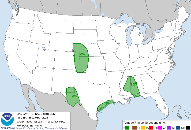
Tornado risk has been bumped up.
 2
2


Posted on 5/20/19 at 11:39 am to NorthEndZone
This is a nasty, nasty setup. It’s one of those events that seems to have pretty much every parameter in place for it to be a big day.
Posted on 5/20/19 at 11:43 am to Roll Tide Ravens
The OT's favorite Oklahoma weathergal Emily Sutton is on the job LINK

Posted on 5/20/19 at 11:47 am to ElOsoBlanco7
Guess I’ll be happy with just a 15% chance of tornado right now considering the percentages to the west of me.
Posted on 5/20/19 at 11:54 am to Roll Tide Ravens
quote:
This is a nasty, nasty setup. It’s one of those events that seems to have pretty much every parameter in place for it to be a big day.
They can be too good sometimes, can lead to clusters. Unfortunately, it's out in dry W OK and TX, so too much moisture is a lot to ask for.
It's going to be dangerous chasing this evening because there's a great rainfall potential in place in Oklahoma. Hunting wedges in the middle of nowhere, with potential flooding is a scary proposition.
Looks like I'm going to be printing some upper air charts and surface readings off for some hand analysis today too. Good day to do some learnin
Posted on 5/20/19 at 11:56 am to Hawgeye
45% here 
Posted on 5/20/19 at 11:59 am to ElOsoBlanco7
quote:
Giant hail
(3-4+ inches in diameter) will be possible.
Gracious, that's like 1/3 as big as my, well, you know

Posted on 5/20/19 at 12:03 pm to StraightCashHomey21
quote:
45% here
Damn, bro. I think that is what the % was for the April 27, 2011 tornadoes that ripped through Alabama.
Have your plan in place now for you, your family, your pets, your friends
Posted on 5/20/19 at 12:04 pm to East Coast Band
quote:i think he said he's on a military base
Damn, bro. I think that is what the % was for the April 27, 2011 tornadoes that ripped through Alabama.
Have your plan in place now for you, your family, your pets, your friends
Posted on 5/20/19 at 12:07 pm to Bedhog
quote:
i think he said he's on a military base
But, I hope he's got his family prepared, too.
Posted on 5/20/19 at 12:09 pm to Bedhog
quote:
i think he said he's on a military base
I've watched the local news coverage of the 2 F5s that went through Moore, Okla... Tinker AFB barely missed getting hammered by both
ETA:
YouTube - KFOR live coverage of Moore F5 Tornado 5/3/99
YouTube - KFOR live coverage of Moore EF5 Tornado 5/20/13
This post was edited on 5/20/19 at 12:16 pm
Posted on 5/20/19 at 12:14 pm to East Coast Band
Severe Studios
One of a few links if you you want to follow storm chasers
Click on menu on top left to find chasers
One of a few links if you you want to follow storm chasers
Click on menu on top left to find chasers
This post was edited on 5/20/19 at 12:16 pm
Posted on 5/20/19 at 12:14 pm to East Coast Band
It was a 45% hatched on 4/27 too to highlight the potential today.
Posted on 5/20/19 at 12:23 pm to Duke
quote:
It was a 45% hatched on 4/27 too to highlight the potential today.
That day still sets itself apart from a forecasting perspective because of the >95% chance of all severe modes in one of the PDS watches. I'm curious if today will come close to that.
Posted on 5/20/19 at 12:25 pm to Quidam65
I had a friend whose wife stuffed herself into the fireplace when the Wichita Falls killer tornado came through in 1979. She survived uninjured. The tornado was so wide she thought, at first, that it was a big rainstorm.

Posted on 5/20/19 at 12:31 pm to chinhoyang
I saw they preemptively closed a lot of schools in the storm crosshairs.
So it’s not just a Louisiana thing.
So it’s not just a Louisiana thing.
Posted on 5/20/19 at 12:33 pm to Duke
I'm in a 2nd floor room at a hotel in OKC. I don't know what to do in a tornado scenario.
Posted on 5/20/19 at 12:34 pm to Bullfrog
quote:Folks here are saying this never happens...until today
I saw they preemptively closed a lot of schools in the storm crosshairs.
Posted on 5/20/19 at 12:36 pm to Cincinnati Bowtie
quote:
I'm in a 2nd floor room at a hotel in OKC. I don't know what to do in a tornado scenario.
put your head between your legs and kiss your arse goodbye
seriously though... get on a low floor and in a hallway or bathroom... since you're in OKC they may even have a special severe storm room to go to so you may want to get a lay of the land quickly
Posted on 5/20/19 at 12:37 pm to ElOsoBlanco7

Warm front drapped over OK. Dry line in NM pushing toward Texas. Watching the dry line for the spark this afternoon. There's a big swatch of 70+ dew points toward central TX and into southern Oklahoma.
CAPE pushing 5500 in parts of western Texas (think a line starting about Lubbock and east of there). So plenty of juice. Looking at some convective inhibition in the Texas, suggesting the high risk zone is well placed to the SE.
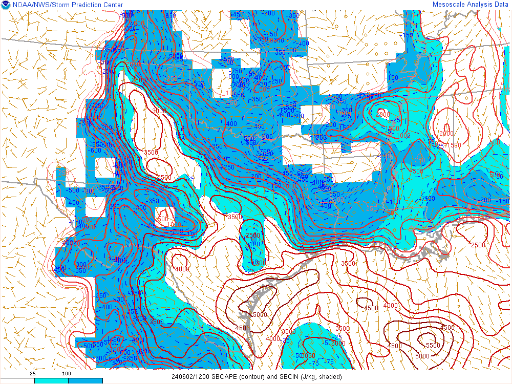
Lines are convective potential energy (CAPE), 4000+ is high. There are 5000+ pushing into the high risk zone. Lines are drawn for every 500 J/kg. Light blue shading is convective inhibition (CIN).

 Page 7 of 31

Popular
Back to top