- My Forums
- Tiger Rant
- LSU Recruiting
- SEC Rant
- Saints Talk
- Pelicans Talk
- More Sports Board
- Fantasy Sports
- Golf Board
- Soccer Board
- O-T Lounge
- Tech Board
- Home/Garden Board
- Outdoor Board
- Health/Fitness Board
- Movie/TV Board
- Book Board
- Music Board
- Political Talk
- Money Talk
- Fark Board
- Gaming Board
- Travel Board
- Food/Drink Board
- Ticket Exchange
- TD Help Board
Customize My Forums- View All Forums
- Topic Sort Options
- Trending Topics
- Recent Topics
- Active Topics
ElOsoBlanco7
| Favorite team: | LSU |
| Location: | 225 |
| Biography: | |
| Interests: | |
| Occupation: | |
| Number of Posts: | 471 |
| Registered on: | 2/7/2019 |
| Online Status: | Not Online |
Recent Posts
Message
re: A Book that made you ask "What did I just Read?"
Posted by ElOsoBlanco7 on 2/16/26 at 10:34 pm to iwyLSUiwy
I just finished The Library at Mount Char after seeing it suggested here. Seriously. What the hell? The most unhinged/amazing thing I've read in a while.
re: Sci-Fi/Fantasy Recommendation & Discussion Thread
Posted by ElOsoBlanco7 on 1/28/26 at 4:15 pm to DukeSilver
My only suggestion would be to wait for Warbreaker until after The Way of Kings. Warbreaker is absolutely my favorite standalone Sanderson novel, and I thought it fit really well when I read it between TWoK and WoR.
re: Brandon Sanderson’s Cosmere lands deal with Apple Tv
Posted by ElOsoBlanco7 on 1/28/26 at 4:12 pm to spehog
quote:
Saying Sanderson will have an unprecedented level of control.
This is the only way it's successful IMO. If everything works out, we could be talking about Stormlight on the same level as Game of Thrones.
re: Deep South Snow Tease 1/17-18
Posted by ElOsoBlanco7 on 1/14/26 at 4:25 pm to Mr Roboto
Deep down, I know that models can be affected by the smallest shift in atmospheric conditions, leading to a big nothing burger. But frick it, let's ride.

re: LHSAA regional playoffs
Posted by ElOsoBlanco7 on 11/21/25 at 10:18 am to Giantkiller
Central
Denham Springs
Brusly
Catholic
St. Michael's
Madison Prep
UHigh
Loyola
LCA
Dunham
AC
Kentwood
OC
Should be some great games. Personally, I'd love to see a Central/Denham rematch in the quarters.
Denham Springs
Brusly
Catholic
St. Michael's
Madison Prep
UHigh
Loyola
LCA
Dunham
AC
Kentwood
OC
Should be some great games. Personally, I'd love to see a Central/Denham rematch in the quarters.
re: Washington National Parks
Posted by ElOsoBlanco7 on 10/30/25 at 7:40 am to zippyputt
quote:
Would love a report on Olympic NP when you get back.
Will do!
Definitely considering slowing down and leaving out Cascades for this trip, based on the responses.
Cheers to all the advice. :cheers:
Washington National Parks
Posted by ElOsoBlanco7 on 10/22/25 at 3:59 pm
I'm planning a trip to go to the 3 National Parks in Washington during June of '26 for the family. Fly into SeaTac, head to Mt. Rainier, then Olympic, and finally North Cascades. It'll be around 8 days between all the parks, so we will have about 2 days minus driving at each park.
What are some things we can't miss? Ideally we would have more time, but with the time we have, should we prioritize some things? I've traveled to Seattle, then down the Colombia River before, but I need all the pro tips I can get for the National Park scene.
What are some things we can't miss? Ideally we would have more time, but with the time we have, should we prioritize some things? I've traveled to Seattle, then down the Colombia River before, but I need all the pro tips I can get for the National Park scene.
re: ALCS Game 7: Mariners 3 vs Blue Jays 4 - FINAL - Jays advance to World Series
Posted by ElOsoBlanco7 on 10/20/25 at 7:34 pm to Thirty Three
quote:
Fun fact: Josh Naylor has two brothers in pro baseball
To add: they all got drafted in the first round out of Canada.
re: ALCS Game 7: Mariners 3 vs Blue Jays 4 - FINAL - Jays advance to World Series
Posted by ElOsoBlanco7 on 10/20/25 at 7:29 pm to TDawg1313
quote:
What a bunch of miserable people in this thread. It's a game 7 to go to the World Series for the first time in franchise history. There's no such thing as unwritten rules that must be followed. Put the pressure on the umpires to get the call right.
Exactly. Dude can be a puss and trail out the line and watch the double play, or give something weird a try. And it almost worked.
re: ALCS Game 7: Mariners 3 vs Blue Jays 4 - FINAL - Jays advance to World Series
Posted by ElOsoBlanco7 on 10/20/25 at 7:26 pm to TDawg1313
Dawg mentality. Naylor can play for me any day.
re: Alaskan cruise
Posted by ElOsoBlanco7 on 10/14/25 at 12:52 pm to rutiger
Went on a Princess Alaskan cruise years ago. Best investment we ever made.
Don't waste your time on whale watching. The excursions often overbook, and it isn't worth it to see the back of one whale for a split second.
If you haven't gotten it, I would highly recommend a balcony room. Waking up, cruising next to the coastline, watching mountains that dart up is truly unlike anything else.
Our favorite excursion was driving into the Yukon Territory. I don't remember all the details, but we got in a van and just drove through the mountains, and ended up in a small brewery where we ate some grilled chicken and drank some local brews. It was amazing.
Pro tip: After the cruise, we spent a week driving down the Columbia River. It was almost as good as the cruise. Multnomah Falls is gorgeous.
re: STTDB (sigh) - needs to die a violent and sudden death
Posted by ElOsoBlanco7 on 9/16/25 at 3:03 pm to clamdip
STTDB
re: What are the best apps for Audiobooks?
Posted by ElOsoBlanco7 on 9/15/25 at 9:27 am to wryder1
I have my subscription for 1 credit per month on Audible, but will mostly use Libby. I go through a good bit of audiobooks, and I only use my monthly credit for books that have ridiculous wait times in Libby. That doesn't happen often, though, and I'm usually able to hoard those credits. Libby is real nice.
S Stadium/Coliseum Tailgating and Parking
Posted by ElOsoBlanco7 on 9/11/25 at 9:45 pm
Anyone have advice for parking and tailgating near the Coliseum? If we want a decent spot, do we need to plan to spend the night or can we park and set up early in the morning? Our old spot got jacked, so any advice is appreciated.
Also, frick the Gators.
Also, frick the Gators.
re: Major Severe Weather Outbreak: March 14-16, 2025
Posted by ElOsoBlanco7 on 3/15/25 at 2:23 pm to LegendInMyMind
re: Major Severe Weather Outbreak: March 14-16, 2025
Posted by ElOsoBlanco7 on 3/15/25 at 11:34 am to dukke v
I just sat through that cell going through Central. Looks like it may be wrapping up and should be warned soon.
re: Is today a Record “earliest time in talking negative about a Coach and Team”
Posted by ElOsoBlanco7 on 2/22/25 at 3:45 pm to namvet6566
We haven't won our first football game in 6 years. I think they may have it there.
re: Go to The Box to watch the baseball game? Head on over to the PMAC and get in for free
Posted by ElOsoBlanco7 on 2/22/25 at 3:35 pm to saint tiger225
It's crazy that we are at the "bribe the fans to attend a game against the #2 team in the country" portion of the CMM era.
re: Southeast Severe Weather: 12/28 - 12/29
Posted by ElOsoBlanco7 on 12/28/24 at 1:40 pm to cgrand
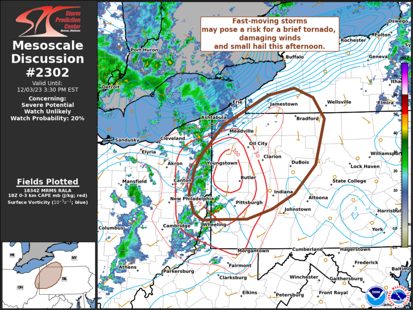
PDS Watch incoming for Central LA to MS

quote:
Mesoscale Discussion 2302
NWS Storm Prediction Center Norman OK
0134 PM CST Sat Dec 28 2024
Areas affected...portions of eastern Texas into Louisiana...western
Mississippi...and extreme southeastern Arkansas
Concerning...Severe potential...Tornado Watch likely
Valid 281934Z - 282100Z
Probability of Watch Issuance...95 percent
SUMMARY...The anticipated primary round of severe storms is expected
to take shape soon. A QLCS, likely preceded by supercells, with all
severe hazards expected. Several EF0-EF2 tornadoes are anticipated,
and a few intense (EF3+) tornadoes are likely. A particularly
dangerous situation tornado watch will be issued within the next
hour or so to address the increasing severe threat.
DISCUSSION...A QLCS is gradually organizing across eastern TX,
preceded by multiple supercells developing within confluence bands.
So far, tornadoes have been the predominant observed severe hazard,
with preliminary local storm reports suggesting that some of these
tornadoes may have been strong. Mesoanalysis trends have shown a 70
kt mid-level jet streak pivoting the trough and approaching the open
warm sector, characterized by 2000-2500 J/kg MLCAPE (given 7 C/km
mid-level lapse rates atop 70F surface dewpoints). As such, the 850
mb low-level jet has already increased to 40 kts, with regional VADs
beginning to show the first signs of low-level hodograph
enlargement.
Trends of increasing low-level shear across the warm sector should
continue into the evening hours ahead of the approaching QLCS and
supercells. Damaging tornado potential should not only persist, but
likely increase into the evening hours, both with the QLCS and
preceding supercells. The most discrete, dominant warm-sector
supercells will have the best potential to produce intense,
potentially long-lived/long-tracked tornadoes. In consideration of
the aforementioned significant tornado potential, a particularly
dangerous situation tornado watch is likely within the next hour.
re: 2024 LHSAA semifinals…
Posted by ElOsoBlanco7 on 12/9/24 at 2:42 pm to NfamousPanda
quote:
Yeah he's just mad that the same team knocked them out of the playoffs at home two years in a row.
Let's not even talk about the red zone play calling, and instead complain about some bullshite that your coaches and fans caused...
re: Tornado! Outbreak Underway New PDS Watch for South LA, MS, & AL
Posted by ElOsoBlanco7 on 12/14/22 at 11:59 am to 50_Tiger
I’ve never seen discrete supercells in SELA like this. Hopefully it turns into nothing, but damn that is ominous.
Popular
 2
2

