- My Forums
- Tiger Rant
- LSU Recruiting
- SEC Rant
- Saints Talk
- Pelicans Talk
- More Sports Board
- Fantasy Sports
- Golf Board
- Soccer Board
- O-T Lounge
- Tech Board
- Home/Garden Board
- Outdoor Board
- Health/Fitness Board
- Movie/TV Board
- Book Board
- Music Board
- Political Talk
- Money Talk
- Fark Board
- Gaming Board
- Travel Board
- Food/Drink Board
- Ticket Exchange
- TD Help Board
Customize My Forums- View All Forums
- Show Left Links
- Topic Sort Options
- Trending Topics
- Recent Topics
- Active Topics
Started By
Message
re: Weather for Monday, May 20. Attention: N TX, Cen. OK, S KS High risk forecast
Posted on 5/20/19 at 7:06 am to WylieTiger
Posted on 5/20/19 at 7:06 am to WylieTiger
10 is the highest
 2
2

Posted on 5/20/19 at 7:16 am to lsuman25
High risk level of 5/5, Torcon of 8 and 9? That’s insane.
Posted on 5/20/19 at 7:16 am to lsuman25
*wakes up pissy because GOT. Checks SPC*
Tornado outbreak you say?
Tornado outbreak you say?
Posted on 5/20/19 at 7:28 am to tWildcat
Yea, the only time we had a 10 was on April 27th 2011.
Posted on 5/20/19 at 7:59 am to tWildcat
quote:
High risk level of 5/5
im dead in the middle of that shite
Posted on 5/20/19 at 8:00 am to lsuman25
OKC now in the High Risk
Posted on 5/20/19 at 8:04 am to lsuman25
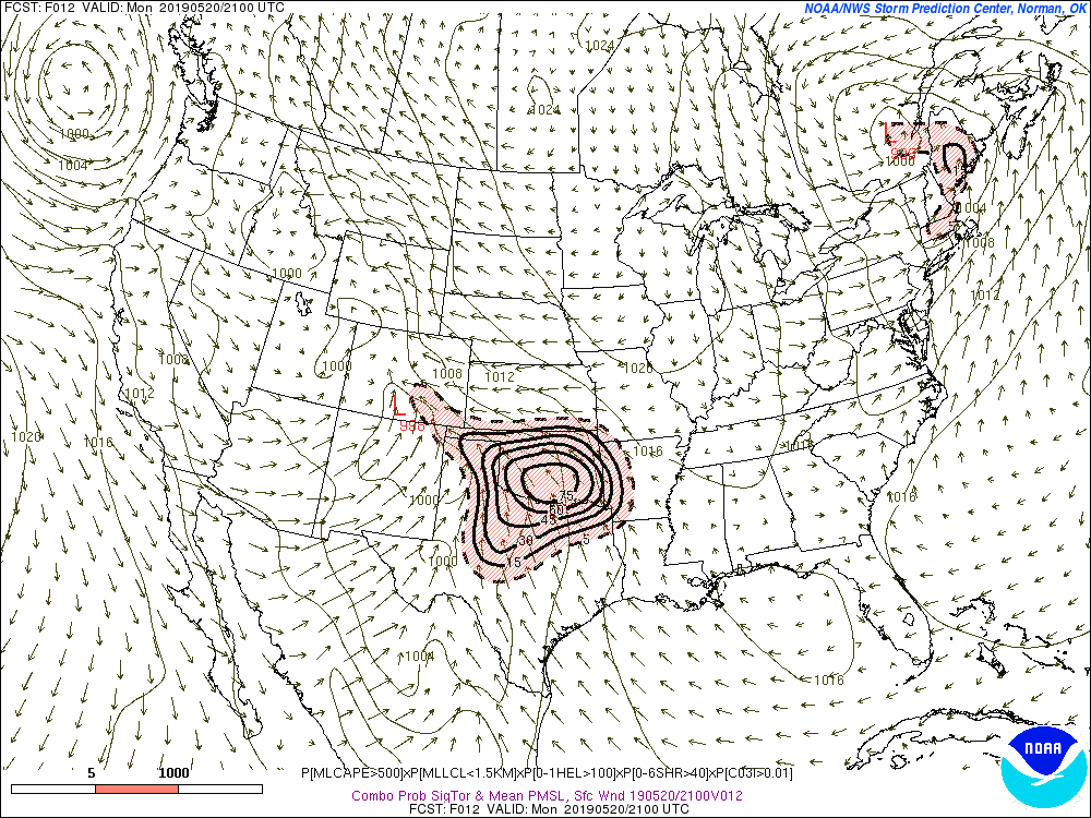
...Southern Plains and vicinity...
For details regarding ongoing hail/wind threats from mainly elevated
storms over the Panhandles/northwest OK area, refer to SPC watches
195/196 and related mesoscale discussions.
A serious outbreak of destructive, tornadic supercells is likely
over parts of this region this afternoon into evening, especially in
the high- and moderate-risk areas. Given the expected fast storm
motions, especially mid-afternoon into evening, a few of the
best-organized supercells may reach an equilibrium with their
already very favorable mesoscale environments long enough to sustain
wide, long-track tornadoes. Very large and damaging hail also is
possible from some of the supercells, along with sporadic severe
downdraft gusts. The hail threat will extend farther north of the
warm front than the wind and tornado potential. The wind-damage
threat may increase this evening as convection aggregates into
clusters or lines, though tornadoes and hail still will be likely
from any relatively discrete storms. QLCS/line-embedded tornadoes
also are possible. Collectively, the multi-episode threat justifies
maintaining a high risk for this outlook cycle.
Thereafter, several supercells should form near the dryline in a
regime of strengthening deep-layer flow and shear. This activity
will move rapidly northeastward into the warm sector, which will be
characterized by large low-level hodographs and buoyancy. With
steep midlevel lapse rates, upper 60s to 70s F surface dew points
and deep moist layers being common, MLCAPE ranging from 2000-5000
J/kg should develop in the moist sector, amidst 55-70-kt effective-
shear magnitudes. Effective SRH 300-500 J/kg should develop --
locally higher, especially near the warm front. Some areas will
experience a rare combination of 3000+ MLCAPE and 400+ J/kg
effective SRH. The parameter space over much of the region today
will support a threat of violent tornadoes, and the likelihood of
multiple significant (EF2+ events).
This post was edited on 5/20/19 at 8:05 am

Posted on 5/20/19 at 8:36 am to lsuman25
Not a fan at all
Posted on 5/20/19 at 8:38 am to Hawgeye
storm should be here in about 20mins
Posted on 5/20/19 at 8:45 am to StraightCashHomey21
quote:
storm should be here in about 20mins
Lower-end hail threat this morning. Big baws are coming later.
It almost reminds me of April 27 2011, when a wave of straight line winds came through early in the morning. I'm hoping it doesn't develop into something like what happened that day, even though all the ingredients are there today.
Stay strapped in today, baw.
Posted on 5/20/19 at 8:50 am to StraightCashHomey21
quote:
im dead in the middle of that shite
Poor choice of wording, IMO

Posted on 5/20/19 at 8:52 am to StraightCashHomey21
Stay safe bro
Posted on 5/20/19 at 8:56 am to McCaigBro69
base isn't evacuating
but the aircraft are
but the aircraft are
Posted on 5/20/19 at 9:09 am to StraightCashHomey21
quote:
Uh, yeah. 09Z SREF has highest probabilities I have ever seen! #highrisk And it extends for 4 periods. Who-wee!
Posted on 5/20/19 at 9:18 am to Woopigsooie20
quote:
Woopigsooie20
Post more.
Posted on 5/20/19 at 9:25 am to Pedro
Yeah, those things are nothing to mess around with.

Posted on 5/20/19 at 9:26 am to SeeeeK
It’ll be interesting to see if any of these earlier storms have laid down any boundaries that could help trigger storm development/intensify storms later on.
Posted on 5/20/19 at 9:30 am to Roll Tide Ravens
looks like we lucked out and missed the morning storms
not supposed to hit until 11 now
not supposed to hit until 11 now

Posted on 5/20/19 at 9:37 am to SeeeeK
quote:
Uh, yeah. 09Z SREF has highest probabilities I have ever seen! #highrisk And it extends for 4 periods. Who-wee!
That isn't remotely true unless that person just started looking at that product. It isn't unusual to see 90 on that product and it isn't even super useful. Today has very high end potential but ridiculous hype doesn't help.

 Page 5 of 31

Popular
Back to top