




- My Forums
- Tiger Rant
- LSU Recruiting
- SEC Rant
- Saints Talk
- Pelicans Talk
- More Sports Board
- Fantasy Sports
- Golf Board
- Soccer Board
- O-T Lounge
- Tech Board
- Home/Garden Board
- Outdoor Board
- Health/Fitness Board
- Movie/TV Board
- Book Board
- Music Board
- Political Talk
- Money Talk
- Fark Board
- Gaming Board
- Travel Board
- Food/Drink Board
- Ticket Exchange
- TD Help Board
Customize My Forums- View All Forums
- Show Left Links
- Topic Sort Options
- Trending Topics
- Recent Topics
- Active Topics
Started By
Message
re: Weather Board: Enhanced (3 out of 5) Risk for Yankees This PM. Tornado Watch For Masters
Posted on 4/11/19 at 2:28 am to Ghost of Colby

Posted on 4/11/19 at 2:28 am to Ghost of Colby
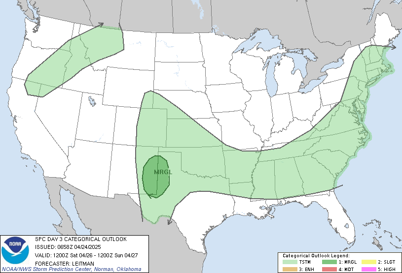
...East Texas through western Alabama...
Models indicate ongoing convection at the start of the period across
north Texas, which may pose a risk for hail given steep mid-level
lapse rates in that area. Through the day, storms will gradually
become more widespread across Arkansas and Louisiana through midday
and toward evening. Weak to moderate buoyancy, strong deep shear,
and backed low-level winds will favor all modes of severe, with
tornadoes and damaging wind gusts being the primary threats.
Particularly concerning is the hint in nearly all guidance that
convection will develop within the free warm sector well removed
from any fronts during peak heating hours. This scenario would
likely result in potential for several tornadoes (a few significant)
and damaging wind gusts assuming instability profiles verify as
currently progged. Concerns remain regarding timing of the wave and
subsequent convective development, with an overall westward trend
apparent in convective evolution compared to yesterday's runs. Some
continued disagreement also exists in most recent guidance with
regard to eastward progression of convection. Instability may also
become a limiting factor if too many storms form and result in
unfavorable storm-scale interactions. Nevertheless, a synoptically
evident severe weather episode appears likely to unfold - especially
within the Enhanced Risk area.
 2
2



Posted on 4/11/19 at 6:03 am to lsuman25
This is a good time for the weatherman to be wrong again

Posted on 4/11/19 at 7:14 am to rds dc
We have a crawfish boil around lunch.
PERFECT
PERFECT
Posted on 4/11/19 at 7:30 am to Adam4848
quote:
We have a crawfish boil around lunch.
Where do you live? If you live in BR the weather will be fine around lunch
Posted on 4/11/19 at 7:36 am to Midtiger farm
No shite I have one Saturday around 1. I guess the after party will be cut short. I’ll be in Metairie


Posted on 4/11/19 at 7:39 am to Duke
Flying down to baton rouge tomorrow til sunday to get away from ny/the snow (yes it snowed here yesterday) and this is what I get to deal with all weekend? 
Hope the forecast improves
Hope the forecast improves

Posted on 4/11/19 at 7:40 am to CuseTiger
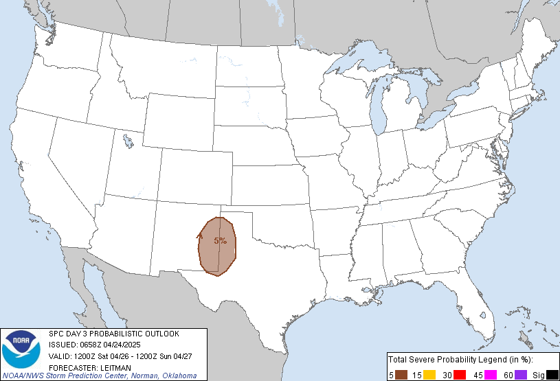
SPC outlook probabilities (probability of severe weather within 25 miles of a given point)
Posted on 4/11/19 at 7:41 am to Roll Tide Ravens
There is also another threat (perhaps even more significant) toward the middle of next week for parts of the SE. Looks like it will be more of a MS, AL, TN threat.
This post was edited on 4/11/19 at 7:42 am

Posted on 4/11/19 at 7:43 am to Duke
stay inside and sleep, thats my plan


Posted on 4/11/19 at 7:51 am to Roll Tide Ravens
Euro simulated IR at 4 PM Saturday.


Posted on 4/11/19 at 7:59 am to Duke
Epic *Superstorm* MrMBB333
Interesting Weather for April. This guy sums it up well.
Interesting Weather for April. This guy sums it up well.
Posted on 4/11/19 at 8:14 am to Bullfrog
Fwiw, that video is about a different system than the one we'll get Saturday.

Posted on 4/11/19 at 8:41 am to CuseTiger
quote:
Flying down to baton rouge tomorrow til sunday to get away from ny/the snow (yes it snowed here yesterday) and this is what I get to deal with all weekend?
Not all weekend at least. Really just overnight Saturday into Sunday in BR. Too bad you're coming for the humidity ramp up. It's been warm but pleasant all week.
Posted on 4/11/19 at 9:05 am to Duke

seriously... I don't think I've been this worried about tornadoes in my life (outside of tropical systems)... then I moved up here to CenLA
Posted on 4/11/19 at 11:32 am to Duke
(no message)
This post was edited on 6/6/20 at 8:55 am

Posted on 4/11/19 at 11:33 am to Duke
These clouds aren’t going to piss all over blues fest in BR will they?
Posted on 4/11/19 at 11:56 am to Hudson00
quote:
Are these going to be rain wrapped tornadoes? Was wondering if we should take a road trip on Saturday out of the danger zone.
Taking a road trip is probably a little much, assuming you have a good structure to stay in. This isn't super outbreak type stuff.
Yes though, a southeast tornado threat with this much moisture at play is likely to produce rain wrapped tornadoes. Just keep an ear out rout for warnings and watch the radar to know if you need to get to your safe space.


Posted on 4/11/19 at 12:14 pm to Duke
How does this look as it goes through north Texas/DFW? I assume it will be late Friday night/early Saturday morning?
Posted on 4/11/19 at 12:18 pm to TH03
So the metroplex should miss the best dynamics that will give Louisiana the problems Saturday afternoon. At least tornado wise. That will all end up out to your southeast early Saturday.
You guys have more of a hail threat overnight Friday and into early Saturday morning. Should just be heavy rain for most of the DFW area but the hail risk will be there.
You guys have more of a hail threat overnight Friday and into early Saturday morning. Should just be heavy rain for most of the DFW area but the hail risk will be there.

 Page 2 of 47

Popular
Back to top
 Follow TigerDroppings for LSU Football News