- My Forums
- Tiger Rant
- LSU Recruiting
- SEC Rant
- Saints Talk
- Pelicans Talk
- More Sports Board
- Fantasy Sports
- Golf Board
- Soccer Board
- O-T Lounge
- Tech Board
- Home/Garden Board
- Outdoor Board
- Health/Fitness Board
- Movie/TV Board
- Book Board
- Music Board
- Political Talk
- Money Talk
- Fark Board
- Gaming Board
- Travel Board
- Food/Drink Board
- Ticket Exchange
- TD Help Board
Customize My Forums- View All Forums
- Show Left Links
- Topic Sort Options
- Trending Topics
- Recent Topics
- Active Topics
Started By
Message
re: Tropical Storm Isaias - O Canada!
Posted on 7/30/20 at 9:56 pm to Roll Tide Ravens
Posted on 7/30/20 at 9:56 pm to Roll Tide Ravens
LINK
1100 PM AST Wed Jul 29 2020
Observations from recent scatterometer passes over the system show
that it now has a sufficiently well-defined center to be
designated as a tropical cyclone.
1100 PM AST Wed Jul 29 2020
Observations from recent scatterometer passes over the system show
that it now has a sufficiently well-defined center to be
designated as a tropical cyclone.
 1
1

Posted on 7/30/20 at 10:07 pm to Duke
Has UF cancelled their season yet??

Posted on 7/30/20 at 10:23 pm to CitizenK
quote:
Observations from recent scatterometer passes over the system show
that it now has a sufficiently well-defined center to be
designated as a tropical cyclone.
That says well-defined center, not well-defined eye. A tropical cyclone can have an obvious center without having a cleared out, visible eye.
Posted on 7/30/20 at 10:33 pm to Roll Tide Ravens
Recon is coming in hot. 87 kt flight level. 65 kt surface estimate.
Which would be Hurricane Isaias.
Officially Hurricane Isaias. 80 mph winds. S
Which would be Hurricane Isaias.
Officially Hurricane Isaias. 80 mph winds. S
This post was edited on 7/30/20 at 10:44 pm
Posted on 7/30/20 at 10:43 pm to Duke
...AIR FORCE HURRICANE HUNTER FINDS ISAIAS IS A HURRICANE...
11:40 PM EDT Thu Jul 30
Location: 20.3°N 72.1°W
Moving: NW at 18 mph
Min pressure: 995 mb
Max sustained: 80 mph
11:40 PM EDT Thu Jul 30
Location: 20.3°N 72.1°W
Moving: NW at 18 mph
Min pressure: 995 mb
Max sustained: 80 mph
Posted on 7/30/20 at 10:46 pm to lsuman25
Isaias is now a hurricane. Hurricane hunters had found winds at the surface in excess of 70mph. Max winds estimated to be 80mph.
quote:
Hurricane Isaias Tropical Cyclone Update
NWS National Hurricane Center Miami FL AL092020
1140 PM EDT Thu Jul 30 2020
...AIR FORCE HURRICANE HUNTER FINDS ISAIAS IS A HURRICANE...
Air Force Reserve Hurricane Hunter aircraft data indicate that the tropical storm has strengthened to a hurricane. The maximum winds are estimated to be 80 mph (130 km/h) with higher gusts.
The government of the Bahamas has issued a Hurricane Warning for the central and southeastern Bahamas.
A special advisory will be issued shortly.
This post was edited on 7/30/20 at 10:47 pm
Posted on 7/30/20 at 10:48 pm to Roll Tide Ravens
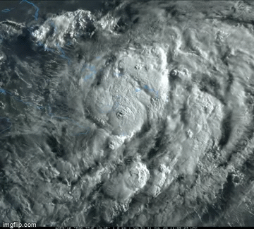
Another nice blowup of convection near the center is ongoing.

Posted on 7/30/20 at 10:49 pm to Roll Tide Ravens
Yeah. He went from large and broad center to a tightly wound ball of central dense overcast after passing over Hispaniola


Posted on 7/30/20 at 11:30 pm to Bobby OG Johnson
Hanna had 80 mph winds and a pressure of 977 mb
Isaac in 2012 had 80 mph winds and a pressure of 966 mb
Isaias has 80 mph winds and a pressure of 995 mb
Crazy stuff
Isaac in 2012 had 80 mph winds and a pressure of 966 mb
Isaias has 80 mph winds and a pressure of 995 mb
Crazy stuff
Posted on 7/30/20 at 11:35 pm to The Boat
It's that steepness of gradient.
It feels like Isaias went from big arse barely tropical cyclone to a big arse supercell mesovorticies.
It feels like Isaias went from big arse barely tropical cyclone to a big arse supercell mesovorticies.
Posted on 7/31/20 at 4:56 am to Duke
Bahamas about to get a boatload of rain...
I’m going with a Cat 2 landfall on the South/North Carolina border early Tuesday morning.
I’m going with a Cat 2 landfall on the South/North Carolina border early Tuesday morning.
This post was edited on 7/31/20 at 5:33 am
Posted on 7/31/20 at 5:52 am to IT_Dawg
Well this sucks. Still heading to OB. 
Posted on 7/31/20 at 6:53 am to Bobby OG Johnson
Bahamas and outer banks will get the brunt of this one
Posted on 7/31/20 at 7:22 am to deltaland
I think there’s a strong possibility it’s shifts west and shoots up Florida then exits around Jax. Really hope that’s wrong and it stays offshore.
Posted on 7/31/20 at 7:28 am to PorkSammich
quote:
NHC is monitoring two other disturbances this morning, both over the tropical Atlantic Ocean. The system near Africa has a chance to become a tropical depression later today, while the system near 45W could slowly develop over the SW Atlantic next week. LINK


Posted on 7/31/20 at 7:31 am to PorkSammich
GTFO. Central Florida isn't even in the cone. Jax is at the very western edge.
quote:
strong possibility
Posted on 7/31/20 at 7:46 am to Bobby OG Johnson
That sucker is blowing up big time. So much for a nothing burger.
Posted on 7/31/20 at 7:51 am to LSUJuice


 Page 35 of 50

Popular
Back to top