- My Forums
- Tiger Rant
- LSU Recruiting
- SEC Rant
- Saints Talk
- Pelicans Talk
- More Sports Board
- Fantasy Sports
- Golf Board
- Soccer Board
- O-T Lounge
- Tech Board
- Home/Garden Board
- Outdoor Board
- Health/Fitness Board
- Movie/TV Board
- Book Board
- Music Board
- Political Talk
- Money Talk
- Fark Board
- Gaming Board
- Travel Board
- Food/Drink Board
- Ticket Exchange
- TD Help Board
Customize My Forums- View All Forums
- Show Left Links
- Topic Sort Options
- Trending Topics
- Recent Topics
- Active Topics
Started By
Message

 1
1

Posted on 6/18/21 at 8:51 am to Cosmo
Even if it isn't a Tropical Storm they are gonna update it to a tropical storm 

Posted on 6/18/21 at 8:53 am to Ignignot
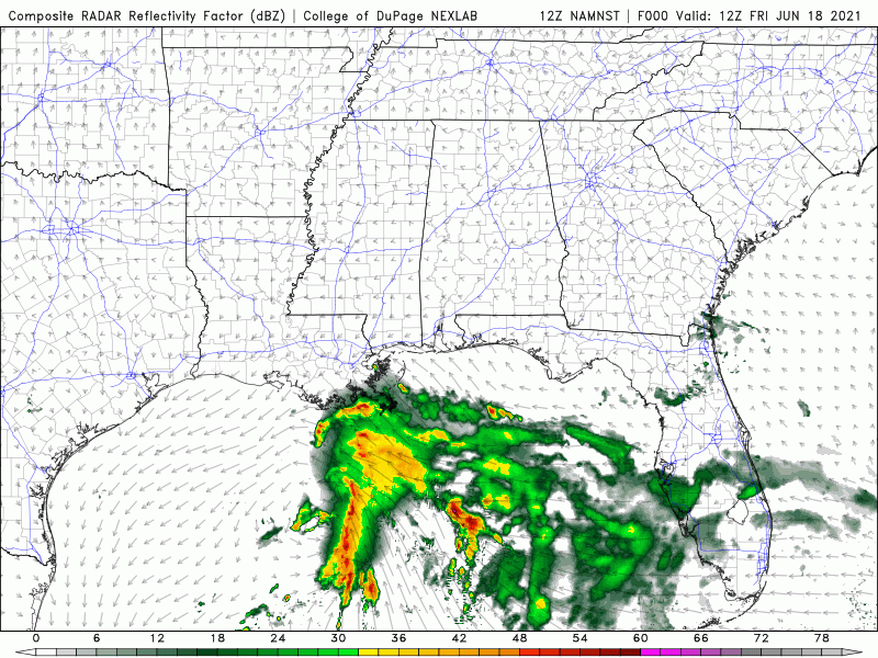
First rain band moving onshore.


Posted on 6/18/21 at 8:53 am to Roll Tide Ravens
Seems to be moving pretty fast
Posted on 6/18/21 at 9:03 am to WicKed WayZ
twss
Posted on 6/18/21 at 9:03 am to WicKed WayZ
considering the track... we don't need many updates from CenLA... but I'll post Nick Mikulas' most recent post just for the heck of it
quote:
Meteorologist Nick Mikulas
This thing might not end up getting a name. It’s still Potential Tropical Cyclone 3. That’s a designation they give systems that will make landfall within 2 days, but aren’t fully formed just yet. It just means they’ll put out a forecast path, and can slap watches and warnings on it. That being said, we aren’t going to see much of anything out of this. Maybe we get a wayward band of showers in the next day, but nothing organized. I think it’s less than an inch of rain areawide, with most getting nothing at all. The front that settles in for Monday and Tuesday will probably bring 1/2-2 inches, which means we get some cooling rain, but don’t have to deal with the whole flooding extravaganza. Be careful if you’re heading east for a beach weekend, but it looks like a heavy rain threat, and not much else out there. So more annoying than dangerous. So I’m back to quiet over here for a bit. I’ll update on the early week rain tomorrow or Sunday.

Posted on 6/18/21 at 9:32 am to rt3
Getting a nice little rain band in Maurepas.
Clouds moving steady east to west.
Clouds moving steady east to west.
Posted on 6/18/21 at 9:41 am to TigerNAtux
Still PTC3 at 10am
SUMMARY OF 1000 AM CDT...1500 UTC...INFORMATION
-----------------------------------------------
LOCATION...26.5N 91.1W
ABOUT 220 MI...355 KM S OF MORGAN CITY LOUISIANA
ABOUT 340 MI...550 KM SSW OF MOBILE ALABAMA
MAXIMUM SUSTAINED WINDS...35 MPH...55 KM/H
PRESENT MOVEMENT...NNE OR 15 DEGREES AT 14 MPH...22 KM/H
MINIMUM CENTRAL PRESSURE...1007 MB...29.74 INCHES
Posted on 6/18/21 at 9:44 am to rt3
quote:
Nick Mikulas
Nicholas Mikulas is welcome anytime.
Posted on 6/18/21 at 9:48 am to rds dc
quote:
This will probably get a name in the Gulf but it's likely going to struggle as the upper level environment looks pretty hostile up through landfall. The exiting trough leaves an upper low over Texas and the system looks to stay tangled up with all of that.
Really no change but the NHC will probably upgrade before landfall. The issue for the NHC is that this system is very disorganized and may actually be close to landfall by this afternoon.

All these images are from the 06z GFS. The image above shows the low level flow, the Red Circle is the overall broad circulation, the 2 Black Circles are the system attempting to close off a surface circulation. The northern circulation may be onshore later this afternoon or evening.

The image above is the upper level setup for this afternoon. We see an upper low over Texas and a upper high over Florida. This does create an area of upper divergence (black box) that is favorable for heavy rain. This setup will keep the system under high shear as it lifts north and then eventually around the top of the high.

The next image shows the low level spin (850mb Vorticity) for tomorrow morning. If you loop this you can see the northern vort rotate around the larger circulation, which kind of stalls it along the coast. Then there is a bit of consolidation before it gets lifted off to the NE.

Overall, conditions are not favorable for any kind of significant organization but the setup does favor a relatively narrow band of heavy rainfall embedded in the larger area of rain associated with the system.
Posted on 6/18/21 at 9:50 am to rds dc
You obviously know what you’re talking about but it all sounds foreign to me lol Sounds like the storm is moving quickly though. Is that right?
Posted on 6/18/21 at 9:55 am to rds dc
Probably going to end up with more rain from the front than the system.

Posted on 6/18/21 at 10:15 am to LegendInMyMind
Morning baw and bawettes,
How much rain we expecting in EBR? Looks like another half an S to the east ...
How much rain we expecting in EBR? Looks like another half an S to the east ...
Posted on 6/18/21 at 10:17 am to Slidellproud
quote:
it all sounds foreign to me lol Sounds like the storm is moving quickly though. Is that right?
Basically there's one big circulation but also a smaller one. That northern one is getting drawn north because it is sandwiched between an upper low to the west (counter-clockwise flow) and a ridge to the east (clockwise flow). rds notes there is a pocket of upper level divergence over SELA and coastal Miss and Alabama. Upper divergence leads to lift and rain, so where he pointed that out is probably the highest rainfall risk.
Storm, if it gets a name, will be a TS in only the most technical sense. Really sloppy, and getting to shore a little faster than expected.
Posted on 6/18/21 at 10:18 am to Duke
So what type of winds are we likely to see in the Baton Rouge area?
Posted on 6/18/21 at 10:19 am to LSUBFA83
quote:
So what type of winds are we likely to see in the Baton Rouge area?
The you wouldn't think a tropical system is nearby type. Wind threats are going to be confined to the heaviest convection to the east of the center.
Posted on 6/18/21 at 10:26 am to Ignignot
Underwriters have to trigger that named storm deductible ……
Posted on 6/18/21 at 10:33 am to michael corleone
Holy crap Sunday looks terrible for Acadiana.
Posted on 6/18/21 at 10:36 am to Duke
So now this thing is basically going to be out of BR by mid afternoon?

Posted on 6/18/21 at 10:51 am to michael corleone
quote:
Underwriters have to trigger that named storm deductible ……
This guy knows what’s up

 Page 53 of 72

Popular
Back to top