- My Forums
- Tiger Rant
- LSU Recruiting
- SEC Rant
- Saints Talk
- Pelicans Talk
- More Sports Board
- Fantasy Sports
- Golf Board
- Soccer Board
- O-T Lounge
- Tech Board
- Home/Garden Board
- Outdoor Board
- Health/Fitness Board
- Movie/TV Board
- Book Board
- Music Board
- Political Talk
- Money Talk
- Fark Board
- Gaming Board
- Travel Board
- Food/Drink Board
- Ticket Exchange
- TD Help Board
Customize My Forums- View All Forums
- Show Left Links
- Topic Sort Options
- Trending Topics
- Recent Topics
- Active Topics
Started By
Message
re: Tornado! Outbreak Underway New PDS Watch for South LA, MS, & AL
Posted on 12/14/22 at 11:48 am to Bobby OG Johnson
Posted on 12/14/22 at 11:48 am to Bobby OG Johnson
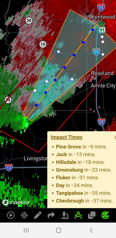
That cell warned for Covington has a pretty good hook on it already.
ETA - next radar update shows it lost the hook but still dangerous. Looks like it is just north of I-12 near LA 1077.
ETA - next radar update shows it lost the hook but still dangerous. Looks like it is just north of I-12 near LA 1077.
This post was edited on 12/14/22 at 11:50 am
 2
2


Posted on 12/14/22 at 11:48 am to LegendInMyMind
Well that track goes over my house, I hope that thing fizzles out before it gets to BTR.
Posted on 12/14/22 at 11:50 am to LegendInMyMind
Prarie dogging in 25 minutes.

Posted on 12/14/22 at 11:52 am to sahikojones
Tangipahoa parish just sent a message at 11:46 that schools will begin early dismissal at 12:00 due to the weather threat. This is with warned storms already in the immediate area.
For those still wondering why school systems make early calls.
For those still wondering why school systems make early calls.
This post was edited on 12/14/22 at 11:53 am

Posted on 12/14/22 at 11:52 am to LegendInMyMind

Posted on 12/14/22 at 11:52 am to rds dc
lEtS dO mAiNtEnAnCe On tHe RaDaR dUrInG a SeVeRe WeAtHeR oUtBrEaK
Posted on 12/14/22 at 11:52 am to LegendInMyMind
The storm due South of BR just to the NE of our warned storm is trying to spin. Watch it.
Posted on 12/14/22 at 11:52 am to Bobby OG Johnson
Old Jefferson/Hoo Shoo Too area looking sketchy.
Posted on 12/14/22 at 11:53 am to DVinBR
quote:
lEtS dO mAiNtEnAnCe On tHe RaDaR dUrInG a SeVeRe WeAtHeR oUtBrEaK
People need to understand what this maintenance actually is before spouting off a bunch of shite. I've covered that twice already.
And also understand that the NWS has more at their disposal than we do. It isn't ideal for them, but it is better than what we have.
This post was edited on 12/14/22 at 11:54 am
Posted on 12/14/22 at 11:54 am to Bobby OG Johnson

Posted on 12/14/22 at 11:54 am to LegendInMyMind
I bet Bassfield and Laurel Ms get a tornado today. And later Eutaw, Al
Posted on 12/14/22 at 11:54 am to Kay
quote:yep, barometer dropping
Old Jefferson/Hoo Shoo Too area looking sketchy.

Posted on 12/14/22 at 11:54 am to MOT
quote:this is incredibly stupid. If you havent made the call already keep the kids in a building where hopefully theres some safe area and protocol.
Tangipahoa parish just sent a message at 11:46 that schools will begin early dismissal at 12:00 due to the weather threat. This is with warned storms already in the immediate area.
Posted on 12/14/22 at 11:55 am to Bobby OG Johnson

Posted on 12/14/22 at 11:55 am to LegendInMyMind
quote:
Folks - the Baton Rouge/New Orleans radar is undergoing critical maintenance and may be intermittently down through Noon CST...
Gotta love New Orleans
Hurricane coming - pumps don’t work
Tornadoes coming - radar don’t work

Posted on 12/14/22 at 11:56 am to Pedro
quote:
this is incredibly stupid. If you havent made the call already keep the kids in a building where hopefully theres some safe area and protocol.
yeah, this is why you had to make that call yesterday. this is potentially a disaster
Posted on 12/14/22 at 11:56 am to DVinBR
This is from the LCH radar for various reasons.
This post was edited on 12/14/22 at 11:57 am

Posted on 12/14/22 at 11:56 am to Kay
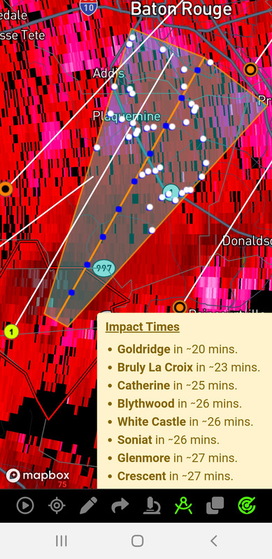
Baton Rouge may luck out that the line has caught up to the cells in BR and is rolling through pretty quick.
Can’t say the same for the northshore. Every single isolated cell looks tornadic and super-celly. There’s 6 of them.
Can’t say the same for the northshore. Every single isolated cell looks tornadic and super-celly. There’s 6 of them.
Posted on 12/14/22 at 11:56 am to NorthEndZone
How the frick is the radar down in Slidell?
Can Slidell ever do anything right?
Can Slidell ever do anything right?

 Page 63 of 108

Popular
Back to top