- My Forums
- Tiger Rant
- LSU Recruiting
- SEC Rant
- Saints Talk
- Pelicans Talk
- More Sports Board
- Fantasy Sports
- Golf Board
- Soccer Board
- O-T Lounge
- Tech Board
- Home/Garden Board
- Outdoor Board
- Health/Fitness Board
- Movie/TV Board
- Book Board
- Music Board
- Political Talk
- Money Talk
- Fark Board
- Gaming Board
- Travel Board
- Food/Drink Board
- Ticket Exchange
- TD Help Board
Customize My Forums- View All Forums
- Show Left Links
- Topic Sort Options
- Trending Topics
- Recent Topics
- Active Topics
Started By
Message
re: Tornado! Outbreak Underway New PDS Watch for South LA, MS, & AL
Posted on 12/14/22 at 9:03 pm to crazyLSUstudent
Posted on 12/14/22 at 9:03 pm to crazyLSUstudent
9600'
 1
1

Posted on 12/14/22 at 9:03 pm to The Boat
quote:
Once the FOs do their damage surveys and give a time for each tornado I like going back and grading my posts based lead time for the tornado or properly identify it when it was on the ground. It’s a good way to keep getting better.
That's not a bad idea at all.
I may have to start considering changing my opinion of you, baw.
This post was edited on 12/14/22 at 9:06 pm
Posted on 12/14/22 at 9:04 pm to crazyLSUstudent
quote:
What elevation are you at again?
Oh....he real high.
Posted on 12/14/22 at 9:09 pm to The Boat
quote:
Nadocast kinda beat SPC again
Nadocast has been performing really well, and it seems especially so this fall/winter.

Posted on 12/14/22 at 9:14 pm to DiamondDog
quote:
Hey man. Update your Ambient Weather Vane. It's not measuring rain. Sincerely, Your Neighborhood Weather Moocher
Haha sorry neighbor. Usually it’s a spider that’s built a nest after a long period of no rain.
Posted on 12/14/22 at 9:14 pm to LegendInMyMind
quote:
Oh....he real high
Posted on 12/14/22 at 9:44 pm to Duke
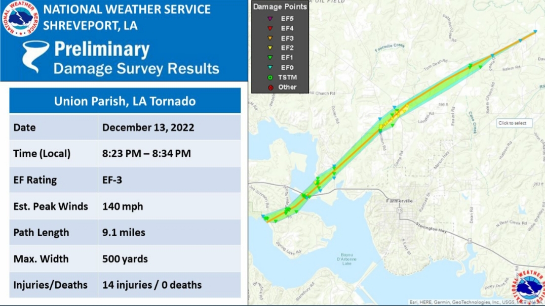
@NWSShreveport
quote:
Today's third survey of 12/13 tornadoes occurred in Union Parish, finding a 9.1 mile EF-3 tornado with peak winds of 140 mph. It tracked from Bayou D'Arbonne Lake to areas north and northeast of Farmerville. There were 14 injuries, but no known fatalities at this time. #lawx

Posted on 12/14/22 at 9:46 pm to LegendInMyMind
That Farmerville tornado was nasty on radar. A 10 mile long EF-3 QLCS tornado. Damn
Posted on 12/14/22 at 9:54 pm to The Boat
Pictures of damage in Jefferson Parish and mention of damage near Canal St.
Has anyone seen tornado tracks for NOLA metro area?
Has anyone seen tornado tracks for NOLA metro area?

Posted on 12/14/22 at 10:07 pm to LegendInMyMind
quote:I can’t believe they missed the forecast so bad.
Posted on 12/14/22 at 11:20 pm to Chad504boy
quote:
Margaret Orr is a bit overdramatic.
i would punch her. "there could be babies flying in the air right now"
Did she actually say this on the air?
Posted on 12/14/22 at 11:22 pm to MOT
quote:
I can’t believe they missed the forecast so bad.
Agreed they hit it pretty good, but if you strip away the colors and warning boxes, and only show the areas that were truly impacted, it looks much much less impressive. And that’s what the people bitching about cancellations and closures will say why they are unnecessary.
Posted on 12/15/22 at 12:28 am to MikeD
Just got power back !

Posted on 12/15/22 at 12:33 am to LegendInMyMind
quote:
From @NycStormChaser (Nick Isabella).
The Baton Rouge area got lucky, but a lot of other places in south Louisiana and Mississippi didn’t. That was a bad storm.
Posted on 12/15/22 at 12:37 am to Stealth Matrix
quote:
Severe hurricane / tornado damage to its' storefront. It's probably the 5th or 6th time that store has taken significant storm damage. God really hates that store in particular.
Maybe poor construction quality is leading to more damage than it should experience?
Posted on 12/15/22 at 2:33 am to MikeD
quote:
Agreed they hit it pretty good, but if you strip away the colors and warning boxes, and only show the areas that were truly impacted, it looks much much less impressive. And that’s what the people bitching about cancellations and closures will say why they are unnecessary.
So if you strip
Away the forecast and areas where storms got bad enough to be deemed worthy of a warning the forecast really wasn't that good? Wat?
I don't see how you could look at the map posted above, including tornado reports, and think this forecast was anything but good if not great
This post was edited on 12/15/22 at 2:37 am

Posted on 12/15/22 at 3:46 am to Wishnitwas1998
00z models are quite frigid.
TWC app is reflecting the change.
TWC app is reflecting the change.
Posted on 12/15/22 at 4:14 am to bayoubengals88
quote:
00z models are quite frigid.
TWC app is reflecting the change.
RDS DC needs to start a new cold front thread.
Let this thread wrap up with the ending of a rough few days of tornadoes
Posted on 12/15/22 at 5:29 am to Sal Minio
She said “people are probably being killed right now”. It was really awkward.
Posted on 12/15/22 at 6:22 am to Wishnitwas1998
quote:
don't see how you could look at the map posted above, including tornado reports, and think this forecast was anything but good if not great
I’m not saying the forecast was incorrect.
I’m saying the map is not an accurate depiction to scale of areas that had a tornado on the ground that caused damage.

 Page 106 of 108

Popular
Back to top