- My Forums
- Tiger Rant
- LSU Recruiting
- SEC Rant
- Saints Talk
- Pelicans Talk
- More Sports Board
- Fantasy Sports
- Golf Board
- Soccer Board
- O-T Lounge
- Tech Board
- Home/Garden Board
- Outdoor Board
- Health/Fitness Board
- Movie/TV Board
- Book Board
- Music Board
- Political Talk
- Money Talk
- Fark Board
- Gaming Board
- Travel Board
- Food/Drink Board
- Ticket Exchange
- TD Help Board
Customize My Forums- View All Forums
- Show Left Links
- Topic Sort Options
- Trending Topics
- Recent Topics
- Active Topics
Started By
Message
re: Tejas Snow/Ice Storm: 2022 Edition (Wednesday Night and Thursday expected timing)
Posted on 2/2/22 at 2:29 pm to LegendInMyMind

Posted on 2/2/22 at 2:29 pm to LegendInMyMind
quote:
Also, HRRR and NAM have both been consistent for a few runs now with between a .250" to a .750" of ice for the Memphis area and the Eastern extent of the storm.
Local guys are now saying .82" for me.
Fuuuuuuuck...
 2
2

Posted on 2/2/22 at 2:30 pm to RummelTiger
I posted gifs of the 18z HRRR on the last page.
Posted on 2/2/22 at 2:31 pm to LegendInMyMind
quote:
I posted gifs of the 18z HRRR on the last page.
Yes, I saw that, but it's not as if those are gospel, so...
Posted on 2/2/22 at 2:33 pm to RummelTiger
quote:
Local guys are now saying .82" for me
I thought my .75" on the high side was too conservative (as in I thought my range too wide and it wasnt going to get there).
The system just ended up a little further south and shifts the freezing rain with it. Winter weather will beat your arse
Posted on 2/2/22 at 2:34 pm to Duke
quote:
Winter weather will beat your arse

Posted on 2/2/22 at 2:34 pm to RummelTiger
Nope. Just the latest model run. Trend has been fairly solid.
This post was edited on 2/2/22 at 2:35 pm
Posted on 2/2/22 at 2:35 pm to LegendInMyMind
quote:
Nope. Just the latest model run. Trend has been fairly solid.
Don't you get sassy with me, bub!
Posted on 2/2/22 at 2:54 pm to goldennugget
quote:
The top post on reddit right now is from /r/technology about how Texas is not prepared and this will be last year all over again and how its all Abbott and the Republican's fault

Posted on 2/2/22 at 2:55 pm to Duke
Mmmmmmmm...Tabasco.

Posted on 2/2/22 at 3:44 pm to LegendInMyMind
NWS FW still showing far NE and N suburbs near McKinney and Greenville still getting the thicker ice.

Posted on 2/2/22 at 3:47 pm to NorthEndZone
Looking at the 18z NAM and the 1"+ totals are back for the TN/AR/MS border area:
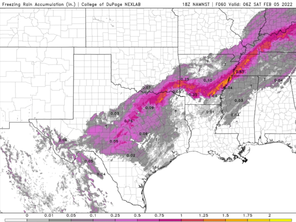
This post was edited on 2/2/22 at 3:48 pm
Posted on 2/2/22 at 4:17 pm to LegendInMyMind
This is really pissing me off.. as of now my flight landing in Dallas at 11am tomorrow is still ‘on time’, so im having to go thru the motions, pack, arrange for pets here at home etc.. Plus Weather Channel is saying if you’re in N Texas tomorrow STAY OFF the roads.. How in the hell am i supposed to get from the airport to my hotel if im not supposed to be on the road ? Am i a pussy if i tell the company im meeting with, ‘Nah , im good, im not flying into that thing’ ?

Posted on 2/2/22 at 4:20 pm to Duke
For my area
URGENT - WINTER WEATHER MESSAGE
National Weather Service Paducah KY
151 PM CST Wed Feb 2 2022
ILZ087-089>091-094-INZ081-082-085>088-KYZ001>022-MOZ112-114-
031100-
/O.CON.KPAH.IS.W.0001.220203T0000Z-220204T1200Z/
Gallatin-Johnson-Pope-Hardin-Massac-Gibson-Pike-Posey-Vanderburgh-
Warrick-Spencer-Fulton-Hickman-Carlisle-Ballard-McCracken-Graves-
Livingston-Marshall-Calloway-Crittenden-Lyon-Trigg-Caldwell-
Union KY-Webster-Hopkins-Christian-Henderson-Daviess-McLean-
Muhlenberg-Todd-Mississippi-New Madrid-
Including the cities of Shawneetown, Vienna, Golconda,
Elizabethtown, Metropolis, Fort Branch, Petersburg, Poseyville,
Evansville, Boonville, Rockport, Hickman, Clinton, Bardwell,
Wickliffe, Paducah, Mayfield, Smithland, Benton, Murray, Marion,
Eddyville, Cadiz, Princeton, Morganfield, Dixon, Madisonville,
Hopkinsville, Henderson, Owensboro, Calhoun, Greenville, Elkton,
Charleston, and New Madrid
151 PM CST Wed Feb 2 2022
...ICE STORM WARNING REMAINS IN EFFECT FROM 6 PM THIS EVENING TO
6 AM CST FRIDAY...
* WHAT...Significant icing expected. Total snow and sleet accumulations
of up to two inches and ice accumulations of three tenths to
three quarters of an inch. Winds gusting as high as 35 mph.
* WHERE...All of southwest Indiana, and all of western Kentucky. New
Madrid and Mississippi counties in southeast Missouri. Massac,
Johnson, Pope, Hardin, and Gallatin counties in southeast
Illinois.
* WHEN...From 6 PM this evening to 6 AM CST Friday.
* IMPACTS...Expect power outages and tree damage due to the ice.
Travel could be impossible. The hazardous conditions could
impact the evening commute tonight, and the morning and evening
commutes on Thursday.
* ADDITIONAL DETAILS...Wind gusts of 25 to 35 mph on Thursday
could damage ice-laden trees and power lines.
PRECAUTIONARY/PREPAREDNESS ACTIONS...
Travel is strongly discouraged. If you must travel, keep an extra
flashlight, food and water in your vehicle in case of an
emergency. Prepare for possible power outages.
&&
Posted on 2/2/22 at 4:21 pm to BK Lounge
You should be sending them a note you're looking forward to seing them and hope the weather holds at DFW to make that possible. See you then!
Weather won't hold...

Posted on 2/2/22 at 4:30 pm to Sao
My flight has a slightly delayed inbound from Atlanta, any more delays and I'll be stuck in Atlanta tonight.

Posted on 2/2/22 at 4:36 pm to RummelTiger
quote:
RummelTiger
You following ATX? Still 1/4" ice expected?
Posted on 2/2/22 at 4:37 pm to Sao
quote:
You should be sending them a note you're looking forward to seing them and hope the weather holds at DFW to make that possible. See you then!
Weather won't hold...
I like ur style.. and i hope you’re right .

Posted on 2/2/22 at 4:40 pm to H2O Tiger
quote:
My flight has a slightly delayed inbound from Atlanta, any more delays and I'll be stuck in Atlanta tonight.
It's 20 minutes

 Page 18 of 32

Popular
Back to top