- My Forums
- Tiger Rant
- LSU Recruiting
- SEC Rant
- Saints Talk
- Pelicans Talk
- More Sports Board
- Fantasy Sports
- Golf Board
- Soccer Board
- O-T Lounge
- Tech Board
- Home/Garden Board
- Outdoor Board
- Health/Fitness Board
- Movie/TV Board
- Book Board
- Music Board
- Political Talk
- Money Talk
- Fark Board
- Gaming Board
- Travel Board
- Food/Drink Board
- Ticket Exchange
- TD Help Board
Customize My Forums- View All Forums
- Show Left Links
- Topic Sort Options
- Trending Topics
- Recent Topics
- Active Topics
Started By
Message
re: Southern Severe Weather Threat (Thursday/Friday)
Posted on 3/2/23 at 12:25 am to footswitch
Posted on 3/2/23 at 12:25 am to footswitch


 0
0


Posted on 3/2/23 at 8:16 am to DVinBR
Well good luck to everyone today in DFW/ETX and beyond!
Hopefully everything that spwans will be in the field in the middle of nowhere.
Hopefully everything that spwans will be in the field in the middle of nowhere.

Posted on 3/2/23 at 9:08 am to 50_Tiger
Heading out to play match at 9:30. Local forecast shows the line moving through between 1130 and noon. Am I going to die?
Posted on 3/2/23 at 9:19 am to 50_Tiger
Im skeptical much can break the cap in the warm sector. I hope Im right bc we dont want any storms taking advantage of that shear profile.
The line breaking as it moves east presents the more likely "discrete" supercell scenario, and thats how Id expect the high end tor potential to materialize, if it does.
The line breaking as it moves east presents the more likely "discrete" supercell scenario, and thats how Id expect the high end tor potential to materialize, if it does.
Posted on 3/2/23 at 9:29 am to Duke
Sun would need to come out to heat the surface up to break the cap and doesn’t look like that’s gonna happen today.
I’m leaning towards a slight bust. There will be severe weather, but I don’t think we see the high end potential.
Sky like this and slight breeze out of the northeast doesn’t scream severe weather. There’s a strong cap in place, surface winds aren’t even aligned with the winds up higher and it’s 63 degrees and drizzling rain
ETA I can’t speak for arklatex maybe since the rain has already left that area and the system will arrive sooner that the cap will break there but I don’t see it happening here. It will be well into the night by the time it gets here
This post was edited on 3/2/23 at 9:32 am
Posted on 3/2/23 at 9:33 am to deltaland
Gonna be a long night on the radar, especially in SHV. There are gonna be QLCS tornados, even with my suspected anemic warm sector.
Posted on 3/2/23 at 9:47 am to LSUGrrrl
quote:
Am I going to die?
Yes but probably not from these storms.
Posted on 3/2/23 at 10:38 am to V Bainbridge
Dallas folks, maybe consider parking your vehicles indoors today.
Posted on 3/2/23 at 10:39 am to LegendInMyMind
quote:
We're approaching 3" of rain already with more to our west.
4.15" at the Tupelo airport near my house between 7PM-10AM
Posted on 3/2/23 at 10:42 am to weadjust
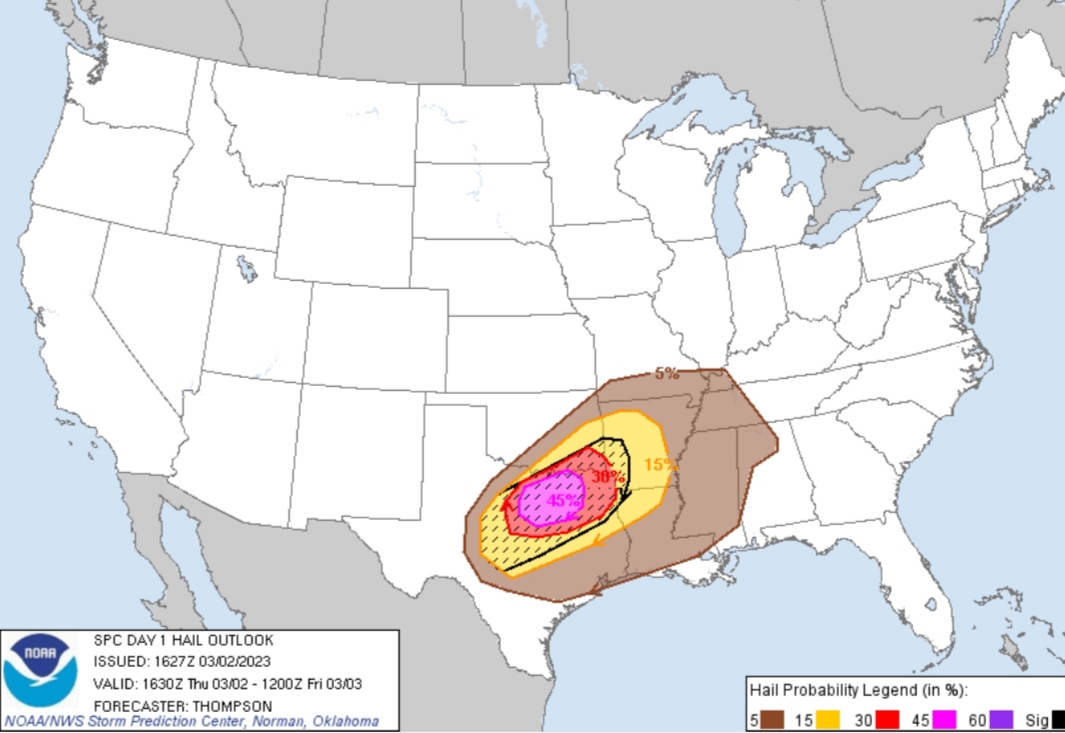
Latest outlook shifted the MDT a bit westward and dropped the tornado probably from 15% to 10%.
Posted on 3/2/23 at 10:44 am to Lsuhoohoo
Well shite I hate this
Its still overcast here near the Airport (DFW)
It seems the NWS is amping this up higher than here
Its still overcast here near the Airport (DFW)
It seems the NWS is amping this up higher than here
This post was edited on 3/2/23 at 10:47 am

Posted on 3/2/23 at 10:58 am to Duke
Time to activate the Barksdale Bubble
Posted on 3/2/23 at 11:04 am to LegendInMyMind


Posted on 3/2/23 at 11:08 am to tigerbutt
quote:
Anytime you clowns see a grey cloud you start screaming end of the world thunderstorms
The nerve of someone providing a thread offering severe thunderstorm warnings. Especially in a an area known for tornadoes.
This has ruined my day and will be leaving work over it.
Posted on 3/2/23 at 11:09 am to NorthEndZone
Dumb question alert… North DFW. based on this picture we’re already in the thick of it? And the storms could start any minute?
I was hoping it wouldn’t start until later this afternoon. Trying to figure out when to childcare home.
I was hoping it wouldn’t start until later this afternoon. Trying to figure out when to childcare home.
This post was edited on 3/2/23 at 11:10 am
Posted on 3/2/23 at 11:15 am to Lazy But Talented
quote:
Dumb question alert… North DFW. based on this picture we’re already in the thick of it? And the storms could start any minute?
I was hoping it wouldn’t start until later this afternoon. Trying to figure out when to childcare home.
Just about to start.
Essentially everyone is going to get "something."
The question is exactly what and how severe that something will be.
Posted on 3/2/23 at 11:18 am to Lazy But Talented
quote:
Dumb question alert… North DFW. based on this picture we’re already in the thick of it? And the storms could start any minute?
Storms should start firing within the next couple hours ahead of the front. Most of those look to be just east of the DFW area with the chance of a couple cells farther west. An hour or two after that storms should begin firing along the front to the west of DFW and first build to the north, with the line then forming to the south. The front/line will then advance east into the evening hours, reaching DFW as early as 5:30 to 6pm.
It also isn't a straightforward line and you'll be done. CAMs have developed storms behind the front, but hopefully those won't be severe.
Posted on 3/2/23 at 11:22 am to LegendInMyMind
I'm hoping the FW and Shreveport NWS offices are able to get balloons up at noon. Little Rock would help, too. The cap was there with the morning launch. It would help a ton to see how strong it is now.
This post was edited on 3/2/23 at 11:23 am

Posted on 3/2/23 at 11:27 am to LegendInMyMind
When do we all die in Shreveport?
Posted on 3/2/23 at 11:30 am to LegendInMyMind
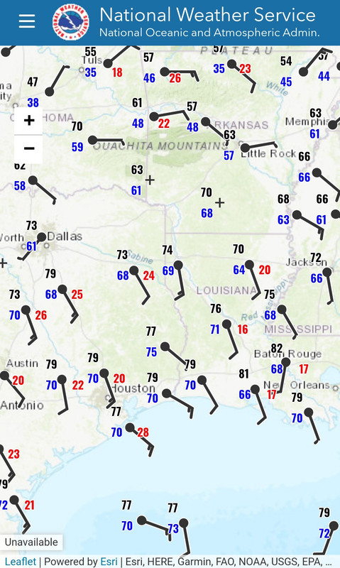
Current surface obs across the warm sector:

 Page 19 of 34

Popular
Back to top