- My Forums
- Tiger Rant
- LSU Recruiting
- SEC Rant
- Saints Talk
- Pelicans Talk
- More Sports Board
- Fantasy Sports
- Golf Board
- Soccer Board
- O-T Lounge
- Tech Board
- Home/Garden Board
- Outdoor Board
- Health/Fitness Board
- Movie/TV Board
- Book Board
- Music Board
- Political Talk
- Money Talk
- Fark Board
- Gaming Board
- Travel Board
- Food/Drink Board
- Ticket Exchange
- TD Help Board
Customize My Forums- View All Forums
- Show Left Links
- Topic Sort Options
- Trending Topics
- Recent Topics
- Active Topics
Started By
Message
re: Southern Severe Weather Threat (Thursday/Friday)
Posted on 3/2/23 at 2:50 pm to LegendInMyMind
Posted on 3/2/23 at 2:50 pm to LegendInMyMind
Future problems brewing along the front.
 1
1


Posted on 3/2/23 at 2:59 pm to LegendInMyMind
Well I dont have to ask where the LLJ is now its clear as day on the radar 


Posted on 3/2/23 at 3:22 pm to Bobby OG Johnson
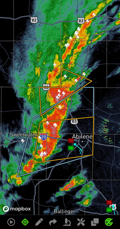
Getting pretty windy just east of Abilene.


Posted on 3/2/23 at 3:58 pm to Roll Tide Ravens
That mass of mini developing supercells in east Texas looks pretty gross
Posted on 3/2/23 at 3:58 pm to Roll Tide Ravens
Discrete cells starting to fire off in ETX

Posted on 3/2/23 at 4:01 pm to Lsuhoohoo
I'm watching the cells north of Gilmer
Gilmer storm maybr showing a bit of rotation?

Gilmer storm maybr showing a bit of rotation?
This post was edited on 3/2/23 at 4:27 pm
Posted on 3/2/23 at 4:23 pm to Lsuhoohoo

Posted on 3/2/23 at 4:23 pm to Roll Tide Ravens
Cloudy all morning, then sun came up and roasted for a few hours. Now cloudy again, winds picking up and tornado watch. Everything seems to be going north of me for now.
Posted on 3/2/23 at 4:36 pm to The Boat
@NWSTornado has been randomly double posting warnings seconds apart on the Twitters the past few storms for some reason


Posted on 3/2/23 at 4:40 pm to Bobby OG Johnson
Watching Ryan Hall and saw the NWS miss an active Tornado on the ground
Starting to think they needed to issue a High warning for ArkLaTex area
Starting to think they needed to issue a High warning for ArkLaTex area
This post was edited on 3/2/23 at 4:41 pm
Posted on 3/2/23 at 4:42 pm to Bobby OG Johnson


Posted on 3/2/23 at 4:45 pm to Lsuhoohoo
Nice hail video from Copic in Sherman
https://mobile.twitter.com/BrandonCopicWx/status/1631415972656472064
https://mobile.twitter.com/BrandonCopicWx/status/1631415972656472064
Posted on 3/2/23 at 4:46 pm to Bobby OG Johnson
The Metroplex dodging gorilla hail to the north, Tornadoes to the East.
That line looking reallllllll omnious though.
That line looking reallllllll omnious though.
Posted on 3/2/23 at 4:48 pm to Lsuhoohoo
If that cap has eroded North Louisiana and southern Ar gonna have a bad time. Those discreet cells will be a problem
That QLCS is looking nasty too
That QLCS is looking nasty too
Posted on 3/2/23 at 4:49 pm to Lsuhoohoo
That storm to the East of Marshall in the screenshot above is trying too.
Posted on 3/2/23 at 4:52 pm to Lsuhoohoo
Meanwhile in Louisiana. This guy looks menacing but not a lot of rotation showing currently

Posted on 3/2/23 at 4:53 pm to Lsuhoohoo
Yall see that Meteor Hailer crossing the red river east of Durant?

 Page 21 of 34

Popular
Back to top