- My Forums
- Tiger Rant
- LSU Recruiting
- SEC Rant
- Saints Talk
- Pelicans Talk
- More Sports Board
- Fantasy Sports
- Golf Board
- Soccer Board
- O-T Lounge
- Tech Board
- Home/Garden Board
- Outdoor Board
- Health/Fitness Board
- Movie/TV Board
- Book Board
- Music Board
- Political Talk
- Money Talk
- Fark Board
- Gaming Board
- Travel Board
- Food/Drink Board
- Ticket Exchange
- TD Help Board
Customize My Forums- View All Forums
- Show Left Links
- Topic Sort Options
- Trending Topics
- Recent Topics
- Active Topics
Started By
Message
 1
1

Posted on 3/2/23 at 12:19 pm to Lazy But Talented
Sun is steady trying to poke out from the clouds here in Shreveport. 75° right now.
Posted on 3/2/23 at 12:28 pm to Lsuhoohoo
quote:
Sun is steady trying to poke out from the clouds here in Shreveport. 75° right now.
Sun coming out is not what you want to happen
Posted on 3/2/23 at 12:33 pm to deltaland
Hell we may end up with a bust in Shreveport. Latest run of the HRRR has the line fizzling and looking pretty unimpressive by the time it's approaching the state line


Posted on 3/2/23 at 12:39 pm to LegendInMyMind
quote:
I'm hoping the FW and Shreveport NWS offices are able to get balloons up at noon
Shreveport says their 18z balloon is in the air now.
Posted on 3/2/23 at 12:43 pm to Lsuhoohoo
Yeah, but......
Don't sleep on the earlier development. Soundings now show the cap eroding and storms firing early. They could lift north and end up being primarily a southern AR problem, but it would be close. Definitely a decent environment for anything remotely discrete if that cap doesn't hold.
Don't sleep on the earlier development. Soundings now show the cap eroding and storms firing early. They could lift north and end up being primarily a southern AR problem, but it would be close. Definitely a decent environment for anything remotely discrete if that cap doesn't hold.
Posted on 3/2/23 at 12:47 pm to LegendInMyMind
quote:
Soundings now show the cap eroding
That was the remaining uncertain bit right?
This post was edited on 3/2/23 at 12:51 pm
Posted on 3/2/23 at 12:58 pm to Lsuhoohoo
18z Shreveport observed sounding:
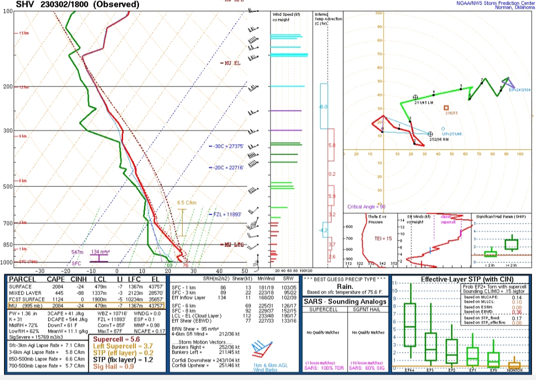
Cap is there, but isn't as strong as earlier.
Fort Worth:
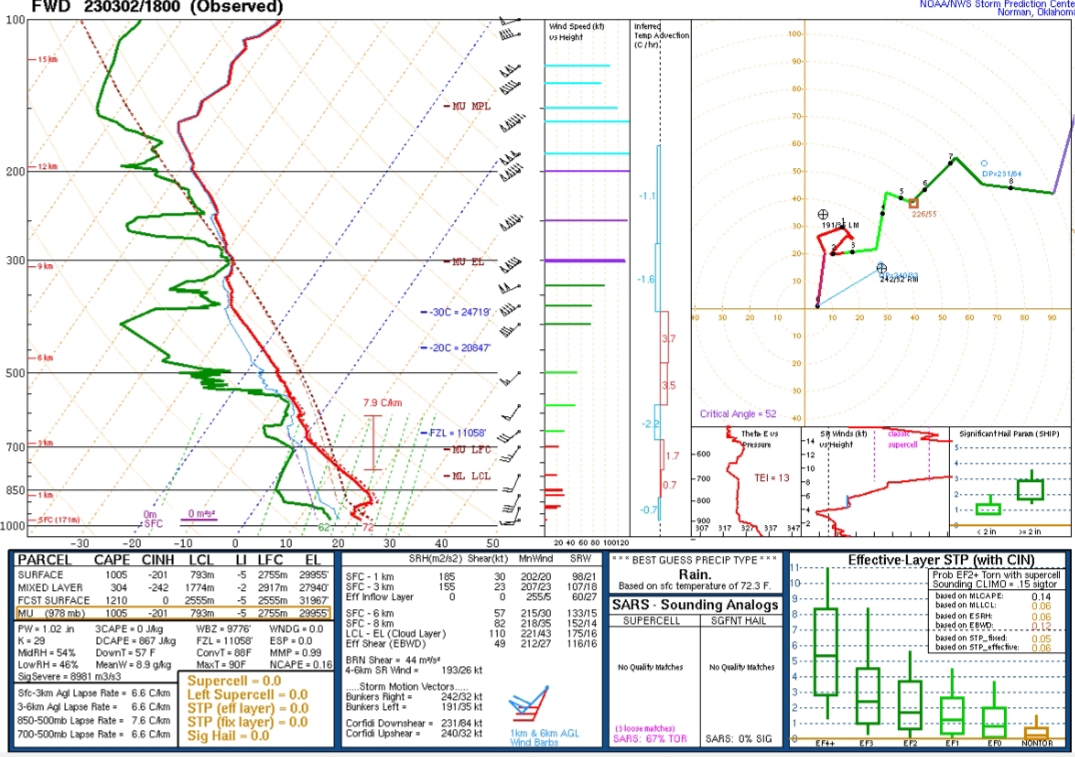
Strong cap still in place.
Cap is there, but isn't as strong as earlier.
Fort Worth:
Strong cap still in place.

Posted on 3/2/23 at 1:01 pm to DVinBR
New severe thunderstorm watch:


Posted on 3/2/23 at 1:16 pm to LegendInMyMind
quote:
Strong cap still in place.
Lets goooo MR CAP
Posted on 3/2/23 at 1:22 pm to LegendInMyMind
quote:
It also isn't a straightforward line and you'll be done. CAMs have developed storms behind the front, but hopefully those won't be severe.
It always sort of breaks my brain when this happens. It's just isn't how things should work in my head
Posted on 3/2/23 at 1:30 pm to Wishnitwas1998
quote:
It always sort of breaks my brain when this happens. It's just isn't how things should work in my head
Yeah, they're usually not severe, but they can compound flash flooding problems.
Posted on 3/2/23 at 1:39 pm to LegendInMyMind
is it outflow that triggers them to pop? it is something i have never grasped and always wondered
Posted on 3/2/23 at 1:40 pm to 50_Tiger
It seems like at least on radar anything close to DFW falls on itself right now.
Posted on 3/2/23 at 2:08 pm to 50_Tiger
What’s the outlook for central Mississippi?
Posted on 3/2/23 at 2:14 pm to 50_Tiger
quote:
It seems like at least on radar anything close to DFW falls on itself right now.
I stand corrected. Pretty big hailer NW of DFW.

Posted on 3/2/23 at 2:17 pm to 50_Tiger
Park under cover in DFW today. This thing is going to drop a ton of hail. Super cold closed low is driving this whole thing. 500 mb temps of -35 over Tucson, Az this morning.

Posted on 3/2/23 at 2:34 pm to The Boat
May have our first Arklatex cell to keep an eye on as it tracks. Not much to it yet

Posted on 3/2/23 at 2:38 pm to The Boat
That Decatur storm is about to drop some big hail.
Decent inflow into it with steady winds ~30 to its south.
Decent inflow into it with steady winds ~30 to its south.
This post was edited on 3/2/23 at 2:41 pm
Posted on 3/2/23 at 2:39 pm to Lsuhoohoo
quote:
May have our first Arklatex cell to keep an eye on as it tracks. Not much to it yet
Watch the lightning.

 Page 20 of 34

Popular
Back to top