- My Forums
- Tiger Rant
- LSU Recruiting
- SEC Rant
- Saints Talk
- Pelicans Talk
- More Sports Board
- Fantasy Sports
- Golf Board
- Soccer Board
- O-T Lounge
- Tech Board
- Home/Garden Board
- Outdoor Board
- Health/Fitness Board
- Movie/TV Board
- Book Board
- Music Board
- Political Talk
- Money Talk
- Fark Board
- Gaming Board
- Travel Board
- Food/Drink Board
- Ticket Exchange
- TD Help Board
Customize My Forums- View All Forums
- Show Left Links
- Topic Sort Options
- Trending Topics
- Recent Topics
- Active Topics
Started By
Message
 1
1

Posted on 6/7/24 at 8:27 am to KamaCausey_LSU
I'll write some stuff up if we get some gulf action looming, dont worry.
Posted on 6/7/24 at 8:37 am to Duke
quote:
I'll write some stuff up if we get some gulf action looming, dont worry.
Awesome! I always enjoy sounding smart by parroting the data that you put out. (And then passing along where I actually read the info.)
Posted on 6/7/24 at 9:31 am to Tarps99
quote:
Must be a new model the doomcasters are using to hype up their YouTube stream counts.
How did AI come to that conclusion? Was it monitoring the entails of Central American pigs, or the tried and true use a blind fold and throw a dart at a map?
ECMWF has been running several AI models for a while now and I haven't been overly impressed. Some of the AI models do show improved skill when using ERA5 reanalysis for initial conditions. Basically, taking historical data and feeding it into the model and then comparing the model out put to a 10 day stretch of past weather.
Posted on 6/7/24 at 9:32 am to rds dc
RDS:
with the rapid improvement of AI in the past year, do you think it will have a significant impact on future storm prognostication?
with the rapid improvement of AI in the past year, do you think it will have a significant impact on future storm prognostication?
Posted on 6/7/24 at 9:54 am to Fun Bunch
quote:
with the rapid improvement of AI in the past year, do you think it will have a significant impact on future storm prognostication?
I think we are approaching the upper limits of model accuracy until there are significant scientific & modeling breakthroughs in the area of convective parametrization (how models handle thunderstorms). The best CAMs still struggle with convective parametrization at even short lead times. It's not uncommon to flip through numerous CAMs and not find any that nailed a 3 hr thunderstorm forecast.
So, IMO, the current AI models are just another version of our current models with the same underlying issues. Even if they eventually improve at H5 or temp forecasting or whatever they will still struggle with one of the single most important drivers of extreme weather events.
Posted on 6/7/24 at 9:56 am to rds dc
quote:
scientific & modeling breakthroughs in the area of convective parametrization
yes, these are words
Posted on 6/7/24 at 9:58 am to rds dc
quote:
I think we are approaching the upper limits of model accuracy until there are significant scientific & modeling breakthroughs in the area of convective parametrization (how models handle thunderstorms). The best CAMs still struggle with convective parametrization at even short lead times. It's not uncommon to flip through numerous CAMs and not find any that nailed a 3 hr thunderstorm forecast.
I was just thinking the same thing.
Posted on 6/7/24 at 10:01 am to rds dc
quote:
I think we are approaching the upper limits of model accuracy until there are significant scientific & modeling breakthroughs in the area of convective parametrization (how models handle thunderstorms). The best CAMs still struggle with convective parametrization at even short lead times. It's not uncommon to flip through numerous CAMs and not find any that nailed a 3 hr thunderstorm forecast.
So, IMO, the current AI models are just another version of our current models with the same underlying issues. Even if they eventually improve at H5 or temp forecasting or whatever they will still struggle with one of the single most important drivers of extreme weather events.
took the words right out of my mouth!..
Posted on 6/7/24 at 10:57 am to Fun Bunch
It means AI isn't fixing anything yet because it isn't effective being used to actually improve the models in part because the understanding of what causes things to happen (or not) is still so imperfect.
Posted on 6/7/24 at 11:19 am to rds dc
quote:
I think we are approaching the upper limits of model accuracy until there are significant scientific & modeling breakthroughs in the area of convective parametrization (how models handle thunderstorms). The best CAMs still struggle with convective parametrization at even short lead times. It's not uncommon to flip through numerous CAMs and not find any that nailed a 3 hr thunderstorm forecast.
We need more super computers. Though, there are some promising machine learning projects out there right now. Atmosphere Analytics and their STORM-Net has done better than I expected with severe/tornadic storms.
Loading Twitter/X Embed...
If tweet fails to load, click here.Posted on 6/7/24 at 11:20 am to BPTiger
If he chooses Rob Gaudets Cajun Navy that man will shite his pants. Attention whore.

Posted on 6/8/24 at 1:19 pm to PierreMartin70508
GFS still has something popping up in the gulf six days out. Currently has it plowing into Florida as slow moving rain maker.


Posted on 6/8/24 at 1:44 pm to Zephyrius
quote:
GFS still has something popping up in the gulf six days out. Currently has it plowing into Florida as slow moving rain maker.
Isnt south Florida in a bad drought. Hopefully this helps with that.
Posted on 6/8/24 at 1:54 pm to Zephyrius
Don’t look too far out something else might be behind it, 7 days later headed to the usual hotspot.
This post was edited on 6/8/24 at 1:55 pm
Posted on 6/8/24 at 2:25 pm to Tarps99
Conditions become more favorable in that time frame for typical mid-end of June mischief. Euro ensembles seem to be the one model that is being aggressive with it. Other models are showing something just not as active as the Euro
Posted on 6/8/24 at 2:42 pm to SWLA92
quote:
Conditions become more favorable in that time frame for typical mid-end of June mischief. Euro ensembles seem to be the one model that is being aggressive with it. Other models are showing something just not as active as the Euro
The biggest concern for people along the Gulf is heavy rain. Some of the telltale signs of an extreme rainfall event are coming together. Hopefully, it stays mostly out over the Gulf.
Posted on 6/9/24 at 12:23 pm to Fun Bunch
quote:
scientific & modeling breakthroughs in the area of convective parametrization
yes, these are words
I’m not convinced they are. Only time will tell.
Posted on 6/9/24 at 12:32 pm to rds dc
That's a lot of rain for a five day span.
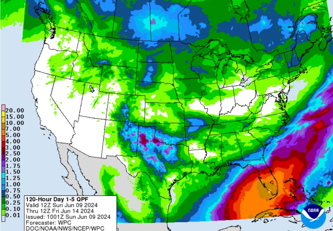
And the rest of the week could add even more.
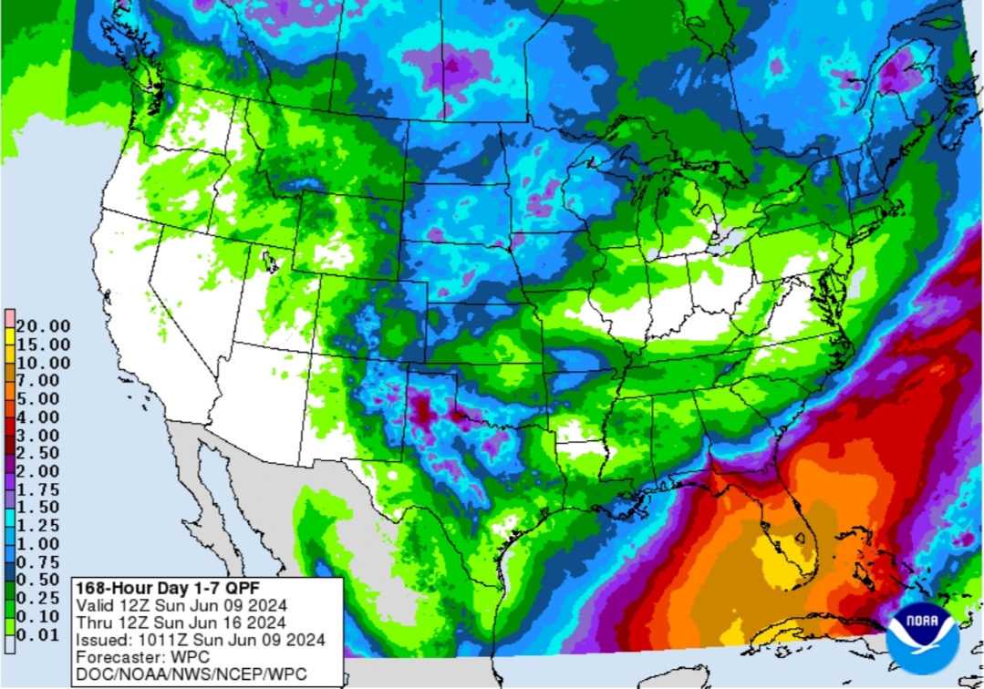
And the rest of the week could add even more.
Posted on 6/9/24 at 1:44 pm to rds dc
quote:
ECMWF has been running several AI models for a while now and I haven't been overly impressed. Some of the AI models do show improved skill when using ERA5 reanalysis for initial conditions
The skill scores have at least been higher and for where I live the Ecwf AI has been owning the operating euro and gfs in the 5-7 day range

 Page 8 of 39

Popular
Back to top