- My Forums
- Tiger Rant
- LSU Recruiting
- SEC Rant
- Saints Talk
- Pelicans Talk
- More Sports Board
- Fantasy Sports
- Golf Board
- Soccer Board
- O-T Lounge
- Tech Board
- Home/Garden Board
- Outdoor Board
- Health/Fitness Board
- Movie/TV Board
- Book Board
- Music Board
- Political Talk
- Money Talk
- Fark Board
- Gaming Board
- Travel Board
- Food/Drink Board
- Ticket Exchange
- TD Help Board
Customize My Forums- View All Forums
- Show Left Links
- Topic Sort Options
- Trending Topics
- Recent Topics
- Active Topics
Started By
Message
re: Mississippi River - How Long would it continue to flow without precipitation?
Posted on 10/18/21 at 11:15 am to Emteein
Posted on 10/18/21 at 11:15 am to Emteein
Looking at that map and all I can think of is... People in Baton Rouge sure are drinking alot of peoples treated wastewater. Explains alot actually.
 2
2


Posted on 10/18/21 at 11:22 am to TimeOutdoors
quote:
Looking at that map and all I can think of is... People in Baton Rouge sure are drinking alot of peoples treated wastewater. Explains alot actually.
BR drinking water comes from an aquifer that's not even really part of the Mississippi River Basin (the map in the OP is actually sort of off for areas east of BR). New Orleans on the other hand...
Posted on 10/18/21 at 11:37 am to Y.A. Tittle
quote:
BR drinking water comes from an aquifer that's not even really part of the Mississippi River Basin
Don't spoil my fun.
Posted on 10/18/21 at 12:08 pm to Emteein
Gets to low, it will probably flow backwards with saltwater from the Gulf of Mexico, until it hits a more higher elevation point probably near Tennessee.
Posted on 10/18/21 at 12:09 pm to Emteein
If the river got low enough, the Gulf might start flowing into it. So it might not dry out at all.
Posted on 10/18/21 at 12:33 pm to Y.A. Tittle
quote:
BR drinking water comes from an aquifer that's not even really part of the Mississippi River Basin
This. Baton Rouge actually has some of the cleanest drinking water in the nation.
New Orleans water is practically undrinkable.
Posted on 10/18/21 at 12:36 pm to Emteein

Posted on 10/18/21 at 1:18 pm to Cosmo
r/theydidthemath
Posted on 10/18/21 at 1:25 pm to southpawcock
If a river dries up but no one sees it because we’re all dead from whatever caused it to dry up, did it really dry up?
This post was edited on 10/18/21 at 1:26 pm
Posted on 10/18/21 at 1:27 pm to Emteein
I’ve lived on the river for all of my 48 years and I’ve never seen the bottom
Posted on 10/18/21 at 1:30 pm to Y.A. Tittle
quote:
the map in the OP is actually sort of off for areas east of BR
Yeah, and the Red and Ouachita/Black don’t end up in the Mississippi anymore, either.
Posted on 10/18/21 at 2:07 pm to Emteein
To get an idea of the drainage area you should use this tool from the USGS: USGS - Streamer
Simply select "Trace Upstream" (or the up arrow if on mobile) then click on the river itself somewhere you want. Keep zooming in and you'll see every little stream there is draining into it. You can also click on Trace Report and it will give you the total miles of streams draining into it as well as the number of streams and waterbodies. For a random click around Baton Rouge it gave 300,143 miles of streams draining into it.
Simply select "Trace Upstream" (or the up arrow if on mobile) then click on the river itself somewhere you want. Keep zooming in and you'll see every little stream there is draining into it. You can also click on Trace Report and it will give you the total miles of streams draining into it as well as the number of streams and waterbodies. For a random click around Baton Rouge it gave 300,143 miles of streams draining into it.
This post was edited on 10/18/21 at 2:10 pm

Posted on 10/18/21 at 2:12 pm to Emteein
Even the Mississippi River has standards:

Posted on 10/18/21 at 2:19 pm to TimeOutdoors
Here is where the Mississippi river starts

Posted on 10/18/21 at 2:22 pm to Cymry Teigr
quote:
To get an idea of the drainage area you should use this tool from the USGS: USGS - Streamer
Oh, wow. I love that!
Posted on 10/18/21 at 2:23 pm to TechDawg2007
quote:
Here is where the Mississippi river starts
I’ve actually been there before. I literally walked across the Mississippi River
Posted on 10/18/21 at 2:39 pm to tgrbaitn08
Ground water in the limestone caverns in the eastern US would keep some of those areas wet, as would all the dams on the Ohio, Tennessee, upper Mississippi.
Even if we go back to Dust Bowl times, how high was the Mississippi those years? I know in east Tennessee, there are folks who can tell you which springs on their property kept running in that drought, AND which ones dried up. And some were wet enough that the neighbors came to them for water as their springs dried up.
If you want more water to flow downstream, cut down your forests. You'd be surprised how much water a massive deciduous tree can take up hourly, much less yearly.

Posted on 10/18/21 at 2:44 pm to Emteein
Well if it quits raining the GOM will work it's way up the river until the river bed goes positive sea level in elevation. This is not particularly a problem except for New Orleans and some of the industry using Mississippi fresh water south of Baton Rouge.
Posted on 10/18/21 at 3:06 pm to TechDawg2007
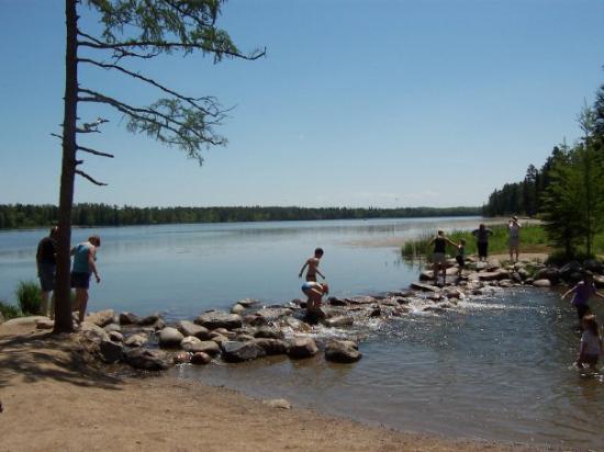
Lake Itasca dam where the MS river begins
Posted on 10/18/21 at 3:17 pm to TechDawg2007
quote:
Here is where the Mississippi river starts
If you go following the largest volume stream at every fork, the headwaters are in Pennsylvania, just south of the New York state line. The Ohio is the larger volume river at its junction with the Mississippi and the Allegheny is the larger river at the head of the Ohio in Pittsburgh.
By length, the headwaters are in Montana, just north of the Idaho state line and west of Yellowstone.

 Page 2 of 3

Popular
Back to top