- My Forums
- Tiger Rant
- LSU Recruiting
- SEC Rant
- Saints Talk
- Pelicans Talk
- More Sports Board
- Fantasy Sports
- Golf Board
- Soccer Board
- O-T Lounge
- Tech Board
- Home/Garden Board
- Outdoor Board
- Health/Fitness Board
- Movie/TV Board
- Book Board
- Music Board
- Political Talk
- Money Talk
- Fark Board
- Gaming Board
- Travel Board
- Food/Drink Board
- Ticket Exchange
- TD Help Board
Customize My Forums- View All Forums
- Show Left Links
- Topic Sort Options
- Trending Topics
- Recent Topics
- Active Topics
Started By
Message
re: Major Severe Weather Outbreak: March 14-16, 2025
Posted on 3/14/25 at 11:40 am to Roll Tide Ravens

Posted on 3/14/25 at 11:40 am to Roll Tide Ravens
Just me but thanks for all the folks who have the knowledge and keep us informed... 
I prolly ask more stupid questions than most but always get a civil answer.
We're down here 7 miles from Gulf Shores and 7 miles from the Eastern Shore of Mobile Bay.
See a lotta weak spinups offa the bay but not a lotta ish like what tomorrow might be.
Tha is for all your efforts and hope all stay safe...
 2
2


Posted on 3/14/25 at 11:40 am to dallasga6
quote:
SPC AC 141630
Day 1 Convective Outlook
NWS Storm Prediction Center Norman OK
1130 AM CDT Fri Mar 14 2025
Valid 141630Z - 151200Z
...THERE IS A MODERATE RISK OF SEVERE THUNDERSTORMS ACROSS PARTS OF
THE MID MISSISSIPPI VALLEY INTO THE LOWER OHIO VALLEY AND
MID-SOUTH...
...SUMMARY...
A regional outbreak of severe thunderstorms is likely this afternoon
through tonight across parts of the Lower/Mid Mississippi Valley and
portions of the Lower Ohio Valley and Mid-South. Numerous tornadoes,
several of which could be strong, widespread severe gusts ranging
from 60 to 100 mph, and scattered large hail up to baseball size all
appear likely.
...Synopsis...
Water-vapor imagery late this morning indicates a powerful and
negatively tilted mid/upper-level shortwave trough over the southern
High Plains. An intense mid-level jet (with winds of 100-115+ kt at
500 mb) will continue to round the base of the trough, and quickly
eject northeastward across OK and eastern KS this afternoon. This
mid-level jet will move over parts of the mid MS Valley and Midwest
this evening and tonight in tandem with the northeastward-advancing
shortwave trough. Strong ascent aloft associated with both of these
features will overspread portions of the central CONUS as a deep
surface cyclone develops northeastward from the central High Plains
into the Upper Midwest this afternoon through tonight. In the low
levels, a dryline will surge eastward across the southern/central
Plains through the day, eventually arcing from the low southeastward
into the Ozarks. A large area of significant severe potential
remains evident across parts of the lower/mid MS Valley into the
Midwest and Mid-South.
...Mid Mississippi Valley into the Midwest and Mid-South...
Ample diurnal heating is expected through this afternoon ahead of
the cyclone, with elevated convection already occurring across parts
of eastern OK into southeast KS and southwest MO. More robust,
surface-based thunderstorms will likely develop by early/mid
afternoon (18-21z) along/east of the dryline from parts of eastern
NE southward into eastern KS/western MO, as a southerly low-level
jet attempts to bring shallow boundary-layer moisture northward into
the mid MS Valley and vicinity. The northern portion of this
convection will be oriented more orthogonal to the ejecting
mid-level jet, and current expectations are for quick upscale growth
into a fast northeastward-moving band, posing a risk for widespread
severe/damaging winds as this activity moves into IA and towards the
MO/IA/IL border region. Given the strength of the low/mid-level flow
and presence of steep lapse rates aloft, along with a well-mixed
boundary layer, intense thunderstorm straight-line gusts peaking
locally in the 80-100 mph range are possible with the stronger
cores/inflections in the band as it matures and moves across parts
of the mid MS Valley, and eventually into the southwestern Great
Lakes this evening through tonight.
Additional, potentially more discrete, severe thunderstorms will
develop this afternoon farther southeast along the wind shift into
central/eastern MO, generally on the northern periphery of somewhat
better low-level moisture from southeast MO southward into the
Mid-South. Stronger high-level flow and ample deep-layer shear over
these will likely promote at least semi-discrete supercells. Latest
model guidance, including various convection-allowing HREF members,
suggest scattered supercells developing late this afternoon and
evening as far south as the MS/AR/TN border region. Have nudged
severe probabilities and the corresponding SLGT/ENH/MDT westward a
little in western/central MO to account for a slightly earlier
initiation. Various NAM/RAP forecast soundings strongly favor
intense supercells capable of large to very large hail (up to 2-3
inches in diameter), and potentially multiple strong to intense
tornadoes this evening as effective SRH rapidly increases in tandem
with a southerly low-level jet strengthening to 50-65+ kt. This
substantial severe threat is expected to continue eastward overnight
into parts of the lower OH Valley/Midwest, before convection
eventually outpaces the low-level moisture return and weakens.
...Lower Mississippi Valley...
Large-scale forcing for ascent appears a bit more nebulous/weak
farther south into the lower MS Valley. Still, the 12Z suite of
guidance shows some potential for surface-based thunderstorms
developing by late this afternoon across the ArkLaMiss region. While
the stronger low/mid-level flow and forcing are expected to remain
to the north of this region, greater low-level moisture and related
instability will be present. This favorable thermodynamic and
kinematic environment will support supercells, with associated
threat for large to very large hail, damaging winds, and tornadoes.
Some of tornadoes could be strong this evening with any sustained
supercells, especially across central MS and vicinity. Have expanded
the ENH to account for this potential, and consideration was given
to expanding the MDT southward into central MS as well. But, there
is still some uncertainty with overall thunderstorm coverage.
Posted on 3/14/25 at 11:41 am to lsuman25
that looks better for me...guess we'll see...
Posted on 3/14/25 at 11:41 am to Roll Tide Ravens
Thank you for the updated thread. A lot of people consult this site and threads like this, and at times has been arguably lifesaving during past weather events.
I think this has the chance to be one of those nasty spring tornado outbreaks that we haven’t seen in a few years, especially Mississippi and west Alabama.
I think this has the chance to be one of those nasty spring tornado outbreaks that we haven’t seen in a few years, especially Mississippi and west Alabama.

Posted on 3/14/25 at 11:42 am to Roll Tide Ravens
Under a high wind/red flag here in Wichita. Glad the actual rain is passing us because if not shite would probably hit the fan with the current temps/sheer I’m sure is present.
Prayers out to all yall under the gun.
Prayers out to all yall under the gun.

Posted on 3/14/25 at 11:44 am to slinger1317
Have you ever had a tornado touch down close to your home? It’s terrifying.
Posted on 3/14/25 at 11:44 am to slinger1317
quote:
Does everything these days have to be SEVERE WEATHER OUTBREAK It's going to be thunderstorms with heavy winds, like we have our entire lives
Don’t start this bullshite. This is a thread worthy outbreak, it has potential to be devastating
Posted on 3/14/25 at 11:44 am to farad
That's for the rest of today until 6am tomorrow. The Day 2 update won't happen until 12:30 this afternoon
Posted on 3/14/25 at 11:45 am to glassman
quote:
Hope it was sans the dog
Posted on 3/14/25 at 11:47 am to lsuman25
I will be out in the field tomorrow on the 59 corridor and will also give updates and send pics if I have any worth sharing. I’ll be somewhere between Hattiesburg and Meridian most likely. Might be one of the best chances to chase in a while, and my love of storms goes back to when I was growing up in Birmingham with weather like this and watching James Spann. I impressed him as a 7-year-old when I could name every county in Alabama unlabeled at one point in time.

Posted on 3/14/25 at 11:47 am to Capt ST
Updraft helicities are looking pretty potent for the Saturday event, per this one model. I've seen a couple more models with similar helicities.
ETA: Per the HRRR
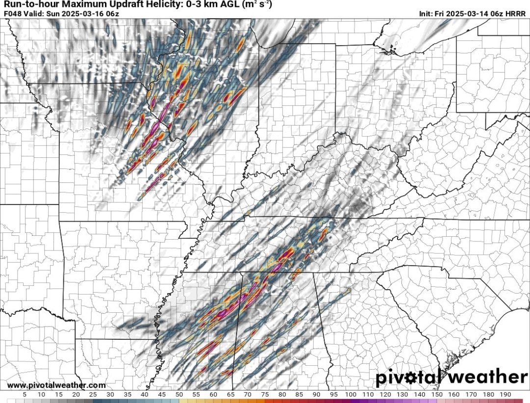
Loading Twitter/X Embed...
If tweet fails to load, click here. ETA: Per the HRRR
This post was edited on 3/14/25 at 11:57 am

Posted on 3/14/25 at 11:49 am to Capt ST
Where are you these days?
Posted on 3/14/25 at 11:51 am to dallasga6
quote:
thanks for all the folks who have the knowledge and keep us informed
Especially those that keeps us informed about the effect this will all have on crayfish prices.
Posted on 3/14/25 at 11:51 am to Capt ST
quote:20 by me?
Dealing with 45 mph sustained winds right now, neighbors dog house just went over the fence.
Posted on 3/14/25 at 11:52 am to slinger1317
quote:
slinger1317
I had a EF-3 pass about a mile from my house in January of '23 while I was at work and my wife, daughter, and MIL were at home in the interior bathroom tub w/blankets and pillows over their heads and it took me 3.5 hours to make it home that night. Don't come on here and make some smartass comment trying to downplay this and then run off.This is going to be a major event and people's lives will be affected.
If you can't see that, you can frick all the way off.
Ignorant motherfricker
This post was edited on 3/14/25 at 12:01 pm
Posted on 3/14/25 at 11:53 am to Roll Tide Ravens
quote:
Chicken has requested a new thread for this event.
Guess Chicken has better faith in you than me to turn this event into a big nothing burger that anyone with any sense would hope for.
You do better graphics anyway.
Posted on 3/14/25 at 11:55 am to slinger1317
quote:
Does everything these days have to be SEVERE WEATHER OUTBREAK
It's going to be thunderstorms with heavy winds, like we have our entire lives
Tell us you've never had a tornado hit you or one of your loved ones without actually telling us.
Posted on 3/14/25 at 11:59 am to choupiquesushi
quote:
20 by me?
I’m roughly 884 miles from you my friend in TX panhandle. 18 wheelers are flipping over left and right, visibility is shite.

Posted on 3/14/25 at 12:00 pm to CE Tiger
quote:
So let’s talk New Orleans/ Metairie and what we should expect?

Seems like it will be similar to what we had MG day. some strong winds in the upper teens in the morning, people bitching about cancelling the parades, then around lunch time we should see some significantly stronger wind with thunderstorms. Not seeing anything about flood warnings, but it appears the chance for thunderstorms runs from 11am to 5/6pm.

Posted on 3/14/25 at 12:00 pm to Roll Tide Ravens
quote:I'd like to apologize to everyone for booking a non-refundable hotel room in New Orleans for Saturday in anticipation of attending the Irish Channel Parade. I think I sealed our fate several weeks ago. My sincere apologies.
This is a very substantial, high-end severe weather threat.

 Page 2 of 88

Popular
Back to top