- My Forums
- Tiger Rant
- LSU Recruiting
- SEC Rant
- Saints Talk
- Pelicans Talk
- More Sports Board
- Fantasy Sports
- Golf Board
- Soccer Board
- O-T Lounge
- Tech Board
- Home/Garden Board
- Outdoor Board
- Health/Fitness Board
- Movie/TV Board
- Book Board
- Music Board
- Political Talk
- Money Talk
- Fark Board
- Gaming Board
- Travel Board
- Food/Drink Board
- Ticket Exchange
- TD Help Board
Customize My Forums- View All Forums
- Show Left Links
- Topic Sort Options
- Trending Topics
- Recent Topics
- Active Topics
Started By
Message

 2
2


Posted on 8/27/20 at 12:00 am to Uncle Stu

Posted on 8/27/20 at 12:00 am to omarlittle
NHC did NOT raise the wind speed at all in spite of those 2 dropsondes we discussed
quote:
000
WTNT63 KNHC 270456
TCUAT3
Hurricane Laura Tropical Cyclone Update
NWS National Hurricane Center Miami FL AL132020
1200 AM CDT Thu Aug 27 2020
...NORTHERN EYEWALL OF LAURA MOVING OVER CAMERON PARISH...
...CATASTROPHIC STORM SURGE, EXTREME WINDS, AND FLASH FLOODING
OCCURING IN SOUTHWESTERN LOUISIANA...
The eyewall of Laura is moving onshore over southwestern Louisiana.
TAKE COVER NOW! Treat these imminent extreme winds as if a tornado
was approaching and move immediately to the safe room in your
shelter. Take action now to protect your life!
The safest place to be during a major landfalling hurricane is in a
reinforced interior room away from windows. Get under a table or
other piece of sturdy furniture. Use mattresses, blankets or pillows
to cover your head and body. Remain in place through the passage of
these life-threatening conditions.
A Weatherflow site in Cameron recently reported a sustained
wind of 84 mph (135 km/h) with a gust to 110 mph (177 km/h).
A HurrNet Station in Cameron recently reported a sustained wind of
74 mph (119 km/h) with a gust to 93 mph (150 km/h).
A National Ocean Service site at Calcasieu Pass reported a wind
gust of 89 mph (132 km/h) within the last hour.
SUMMARY OF 1200 AM CDT...0500 UTC...INFORMATION
-----------------------------------------------
LOCATION...29.5N 93.3W
ABOUT 40 MI...65 KM S OF LAKE CHARLES LOUISIANA
ABOUT 45 MI...70 KM SE OF PORT ARTHUR TEXAS
MAXIMUM SUSTAINED WINDS...150 MPH...240 KM/H
PRESENT MOVEMENT...NNW OR 345 DEGREES AT 15 MPH...24 KM/H
MINIMUM CENTRAL PRESSURE...938 MB...27.70 INCHES
$$
Forecaster Zelinsky/Cangialosi
Posted on 8/27/20 at 12:01 am to The Boat
quote:
There's still gonna be a ton of home repair needed with this extreme wind but that's easier to deal with than a flood. At least you might be able to live in your home while it's repaired.
we don't have flood insurance on that house so it's a big deal
Posted on 8/27/20 at 12:01 am to Not Cooper
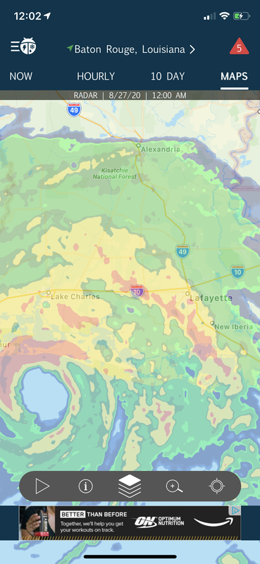
Looking at katc radar it looks like the bad rain is done for now at least?? Wind still kicking a good bit.

Posted on 8/27/20 at 12:01 am to Loungefly85
quote:
I’d pay good money to be in a cement building 25ft in the air on cement pilings in Cameron right now.
But since that’s not possible, I couldn’t imagine being there in any other situation. Even though the courthouse survived Audrey, Rita, and Ike you couldn’t pay me to pass this storm there.
Well you could have driven down and road it out on top of the courthouse.
Trust me, my grandfather and pregnant grandmother did that for Audrey, and listening to his stories, you fricking do not want to do that.
Posted on 8/27/20 at 12:02 am to rds dc
Entergy should be proud of how well their system in lake charles has held up this long

Posted on 8/27/20 at 12:02 am to RummelTiger
quote:
Would be Eastern...
I'm just repeating that crazy Brett Adair who said on the feed he has a bud at the NWS who just sent him that
when some nut is parked in the middle of road in downtown LC, who knows what to believe
Posted on 8/27/20 at 12:02 am to rt3
quote:
NHC did NOT raise the wind speed at all in spite of those 2 dropsondes we discussed
I thought they might go to 155 but the recon data just isn't quite there.
Posted on 8/27/20 at 12:02 am to RummelTiger
quote:
that fricker just said 175mph on the western eyewall
Would be Eastern...
Nice catch. Would only be the western eyewall if the storm was headed south.
Posted on 8/27/20 at 12:02 am to DVinBR
Abbeville too!
Posted on 8/27/20 at 12:02 am to lsu777
like i said earlier IF that storm chaser got stuck
you got a storm surge coming and literally nothing but marsh, aligators, and snakes around you for 3-4 days in 95 degree heat
you got a storm surge coming and literally nothing but marsh, aligators, and snakes around you for 3-4 days in 95 degree heat
Posted on 8/27/20 at 12:02 am to tiger91
quote:
Looking at katc radar it looks like the bad rain is done for now at least?? Wind still kicking a good bit.
Youre in a slot now, think of it as time to gather your thoughts.
Posted on 8/27/20 at 12:03 am to DVinBR
quote:i heard they're going to shut it off shortly
Entergy should be proud of how well their system in lake charles has held up this long
Posted on 8/27/20 at 12:03 am to fargobison
Calcasieu Pass instrument still highest of 73 sustained and 96 gust that it has reported.
Posted on 8/27/20 at 12:03 am to SlowFlowPro
Looking at that picture, I 100% think you will be fine flood wise. Especially now that it seems worst surge will go just to the east of us.
My aunt's house in Cameron that survived Rita and Ike.....year if it hits a true 15' in Cameron...it gone. Won't be anything but maybe pilings left.
My aunt's house in Cameron that survived Rita and Ike.....year if it hits a true 15' in Cameron...it gone. Won't be anything but maybe pilings left.

Posted on 8/27/20 at 12:04 am to SlowFlowPro
That just got real, and they're only in 50 mph, 74 mph gusts.

Posted on 8/27/20 at 12:04 am to DVinBR
quote:
Entergy should be proud of how well their system in lake charles has held up this long
It's early. Those winds are leaning.. leaning.. leaning on the trees and power pole like offensive linemen in the 1st half. It's about the duration. Those winds are going to start crushing those trees like LSU's 2011 offensive line in the 2nd half.
Posted on 8/27/20 at 12:04 am to tiger91
Looks like Lafayette is about to get some shite soon. Obviously nothing compare to the west, but some nasty stuff in its own right.

 Page 642 of 815

Popular
Back to top