- My Forums
- Tiger Rant
- LSU Recruiting
- SEC Rant
- Saints Talk
- Pelicans Talk
- More Sports Board
- Fantasy Sports
- Golf Board
- Soccer Board
- O-T Lounge
- Tech Board
- Home/Garden Board
- Outdoor Board
- Health/Fitness Board
- Movie/TV Board
- Book Board
- Music Board
- Political Talk
- Money Talk
- Fark Board
- Gaming Board
- Travel Board
- Food/Drink Board
- Ticket Exchange
- TD Help Board
Customize My Forums- View All Forums
- Show Left Links
- Topic Sort Options
- Trending Topics
- Recent Topics
- Active Topics
Started By
Message
re: Ian Observation Thread (Storm Track and Radar inside)
Posted on 9/28/22 at 11:35 am to beebefootballfan
Posted on 9/28/22 at 11:35 am to beebefootballfan
(no message)
This post was edited on 9/28/22 at 11:37 am
 0
0

Posted on 9/28/22 at 11:35 am to Slagathor
Some bushes at the Naples Pier just tapped out but the pier and closed sign chain are hanging in there
Posted on 9/28/22 at 11:35 am to Tesla
quote:
What is the ICAO code for “fricked?”
Dunno, but the ICD-10 code is I69.D

Posted on 9/28/22 at 11:35 am to loogaroo
quote:
This is going to beat Katrina's MS surge I'm afraid.
No indeed. Katrina was 32' in Bay St. Louis, MS. That was the pure definition of act of God.
Posted on 9/28/22 at 11:36 am to Dawgfan247
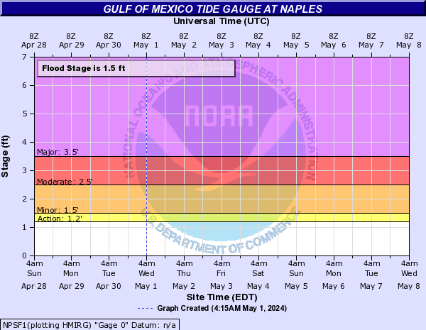
6.17 feet above normal predicted tide in Naples.
Posted on 9/28/22 at 11:36 am to 1MileTiger
Cape Coral is going to be really bad when Ian rolls onshore. It will be in the part of the eyewall that will be producing mesovortices, and it will just be crawling. Don't be surprised to see more tornado-like damage there if Ian doesn't weaken enough to effect that aspect of the storm.
Posted on 9/28/22 at 11:36 am to LegendInMyMind
The waves are really starting to shoot up thru the decking on that pier.
LINK
And it’s gone
LINK
And it’s gone
This post was edited on 9/28/22 at 11:39 am
Posted on 9/28/22 at 11:36 am to back9Tiger
Naples cam went down
Posted on 9/28/22 at 11:37 am to LegendInMyMind
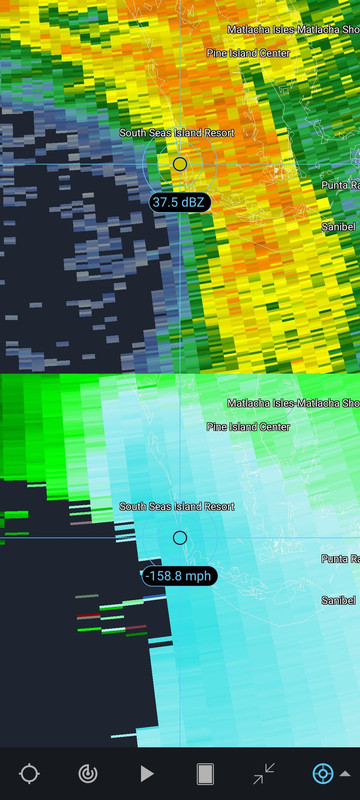
I saw these earlier. Supposedly they are sustained winds based on radar.

Posted on 9/28/22 at 11:37 am to Dawgfan247
RIP pier cam

Posted on 9/28/22 at 11:37 am to LegendInMyMind
quote:
Cape Coral is going to be really bad when Ian rolls onshore. It will be in the part of the eyewall that will be producing mesovortices, and it will just be crawling. Don't be surprised to see more tornado-like damage there if Ian doesn't weaken enough to effect that aspect of the storm.
Yep, with the orientation of the coast line there, that area looks to be in a direct onshore flow. That should be where the worst surge is.
Posted on 9/28/22 at 11:37 am to WestSideTiger
quote:
The waves are really starting to shoot up thru the decking on that pier.
At this point the pier is just fricking with Ian. In a few minutes the pier is gonna have enough and shut this whole storm bullshite down
Posted on 9/28/22 at 11:38 am to beebefootballfan
quote:
Please quit posting the my buddy just sent me this shark in the water on the freeway pic. It's been around for yeara. It's not real.


Posted on 9/28/22 at 11:38 am to LegendInMyMind
Posted on 9/28/22 at 11:38 am to WestSideTiger
Y'all still have the Naples pier cam???
Posted on 9/28/22 at 11:38 am to WestSideTiger
My friends sticking around in port charlotte, on the water, just posted a video 20 minutes ago. Water level wasn't outrageous, yet.
Posted on 9/28/22 at 11:38 am to Hurricane2020
I will say the NBC 2/ABC 7 mets in Ft. Myers are very good from what I've watched.
LINK if you want it
LINK if you want it
This post was edited on 9/28/22 at 11:39 am
Posted on 9/28/22 at 11:39 am to WestSideTiger
Posted on 9/28/22 at 11:39 am to MoarKilometers
Dammit now do I have to work with the Naples pier cam down
Posted on 9/28/22 at 11:39 am to back9Tiger
quote:
Katrina was 32' in Bay St. Louis, MS
In the mouth of the Jourdan River for sure, Old Towne didn’t directly take that though. I’m 24’ above sea level and we got 3.5’ of water in the house…flowing out from the river bizarrely enough.

 Page 336 of 465

Popular
Back to top