- My Forums
- Tiger Rant
- LSU Recruiting
- SEC Rant
- Saints Talk
- Pelicans Talk
- More Sports Board
- Fantasy Sports
- Golf Board
- Soccer Board
- O-T Lounge
- Tech Board
- Home/Garden Board
- Outdoor Board
- Health/Fitness Board
- Movie/TV Board
- Book Board
- Music Board
- Political Talk
- Money Talk
- Fark Board
- Gaming Board
- Travel Board
- Food/Drink Board
- Ticket Exchange
- TD Help Board
Customize My Forums- View All Forums
- Show Left Links
- Topic Sort Options
- Trending Topics
- Recent Topics
- Active Topics
Started By
Message

 1
1


Posted on 9/28/22 at 10:00 am to Roll Tide Ravens
New 10am CDT, 11am EDT advisory. Winds still at 155mph sustained, pressure 937mb. So still a Category 4.

BULLETIN
Hurricane Ian Advisory Number 24
NWS National Hurricane Center Miami FL AL092022
1100 AM EDT Wed Sep 28 2022
...EXTREMELY DANGEROUS EYEWALL OF IAN MOVING ONSHORE...
...IAN WILL CAUSE CATASTROPHIC STORM SURGE, WINDS, AND FLOODING IN
THE FLORIDA PENINSULA SOON...
SUMMARY OF 1100 AM EDT...1500 UTC...INFORMATION
-----------------------------------------------
LOCATION...26.3N 82.5W
ABOUT 45 MI...75 KM WNW OF NAPLES FLORIDA
ABOUT 50 MI...80 KM SSW OF PUNTA GORDA FLORIDA
MAXIMUM SUSTAINED WINDS...155 MPH...250 KM/H
PRESENT MOVEMENT...NNE OR 15 DEGREES AT 9 MPH...15 KM/H
MINIMUM CENTRAL PRESSURE...937 MB...27.67 INCHES
This post was edited on 9/28/22 at 10:01 am

Posted on 9/28/22 at 10:00 am to Roll Tide Ravens
Yep, livestream out at Fort Myers. shite was getting real, too.
Posted on 9/28/22 at 10:00 am to Oates Mustache
i always appreciate his (wxman57) posts on storm2k.org
Posted on 9/28/22 at 10:01 am to deltaland
LINK

quote:
I can't overstate how serious the storm surge threat is in southwest Florida. #Ian will drive deadly surge into Cape Coral and Fort Myers, placing much of the area under water. If you live near the ocean in a surge zone, this is your last chance to leave...
This post was edited on 9/28/22 at 10:02 am
Posted on 9/28/22 at 10:01 am to TigersnJeeps
Alright, what's our next cam to watch?
Posted on 9/28/22 at 10:01 am to Festus
im watching Brett Adair, cant get Reed to load on YT. any better streams?

Posted on 9/28/22 at 10:01 am to LSUGrrrl
quote:
And there’s our first casualty of this watch.
Don't count it out yet. We had the brave camera in Grand Isle go underwater then come back to life after the surge.
Posted on 9/28/22 at 10:01 am to LegendInMyMind
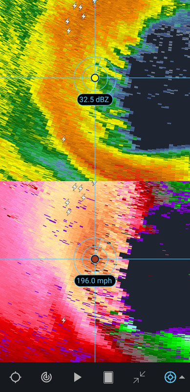
See, pixel picking can give you some huge numbers....

Posted on 9/28/22 at 10:01 am to Roll Tide Ravens
Staying at 155...interesting.

Posted on 9/28/22 at 10:01 am to rds dc
quote:
ZCZC MIATCDAT4 ALL
TTAA00 KNHC DDHHMM
Hurricane Ian Discussion Number 24
NWS National Hurricane Center Miami FL AL092022
1100 AM EDT Wed Sep 28 2022
Air Force Reserve and NOAA Hurricane Hunter data was absolutely
critical this morning in diagnosing the rapid intensification of
Ian, despite both planes undergoing multiple eyewall penetrations
experiencing severe turbulence. That data supported an intensity of
about 135 kt a few hours ago. Since that time, high-resolution
Tampa Doppler radar data has been sampling the eyewall near 10,000
ft with winds up to 155 kt, indicating that Ian is on the threshold
of category 5 status. The maximum winds are set to 135 kt on this
advisory.

Posted on 9/28/22 at 10:02 am to LegendInMyMind

Ian is fricking angry, look at all that lightning.
This post was edited on 9/28/22 at 10:03 am

Posted on 9/28/22 at 10:02 am to Costanza
In a meeting for the next hour but following along on the NBC2/ABC7 stream. Thanks to whoever posted that a few pages back.
Posted on 9/28/22 at 10:02 am to Oates Mustache
Looks like Sanibel/Captiva...

Posted on 9/28/22 at 10:02 am to BritLSUfan
Posted on 9/28/22 at 10:03 am to Roll Tide Ravens
SO much going on, I missed that surge was upped to 18 feet...mercy

Posted on 9/28/22 at 10:03 am to Lord_Ford
quote:
any better streams?
None that I'm aware of. But I'm a poacher. I just wait for someone else to find something good, post a link, then I jump in. I'm at work and too lazy to search.
Posted on 9/28/22 at 10:04 am to Festus
Posted on 9/28/22 at 10:04 am to H2O Tiger
next 8-10 hours going to be brutal.
Posted on 9/28/22 at 10:04 am to Wally Sparks
quote:
Old-school Weather Channel stream on Ian, looks like the mid-90s
That stream is the best. Dude reverse-engineered an actual unit and wrote their own program to run it. He's actually added Airport Conditions, a Daypart Forecast, and a Regional Radar - all things the original unit didn't do.

 Page 319 of 465

Popular
Back to top