- My Forums
- Tiger Rant
- LSU Recruiting
- SEC Rant
- Saints Talk
- Pelicans Talk
- More Sports Board
- Fantasy Sports
- Golf Board
- Soccer Board
- O-T Lounge
- Tech Board
- Home/Garden Board
- Outdoor Board
- Health/Fitness Board
- Movie/TV Board
- Book Board
- Music Board
- Political Talk
- Money Talk
- Fark Board
- Gaming Board
- Travel Board
- Food/Drink Board
- Ticket Exchange
- TD Help Board
Customize My Forums- View All Forums
- Show Left Links
- Topic Sort Options
- Trending Topics
- Recent Topics
- Active Topics
Started By
Message
re: Hurricane/Tropical Storm Idalia Discussion Thread
Posted on 8/29/23 at 11:50 am to LanierSpots

Posted on 8/29/23 at 11:50 am to LanierSpots
quote:I am feeling good about our situation. Just another one to ride out.
We should be OK over there right?
 1
1

Posted on 8/29/23 at 11:51 am to Wolfhound45
Lightning in the inner core and more regular in the outer band:
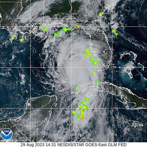
This post was edited on 8/29/23 at 11:52 am

Posted on 8/29/23 at 11:51 am to Tigris
quote:
We had Cat. 3 winds for Michael and the trees did remarkably well. But once you got to Cat. 4 areas the trees were a mess. That whole swath from Mexico Beach to Marianna and north was amazing to see. Pines lying everywhere.
Truly. Never seen hurricane damage like that.
Posted on 8/29/23 at 11:54 am to rds dc
Probably already been asked, but anybody storm chasing and live streaming the hurricane?

Posted on 8/29/23 at 11:55 am to Duke
quote:
Why?
It aint going to change much from here. Major hurricane into the Big Bend. Most of the questions are answered at this point.
A BIG difference between a Cat. 3 landing to the east of me, and a Cat. 4 direct hit. 30 miles makes a big difference (but yeah, it's hard to nail down until probably too late to be sure).

Posted on 8/29/23 at 11:55 am to LegendInMyMind
Any projections for Gainesville? This could be rough for the University of Florida Campus.
Posted on 8/29/23 at 11:55 am to tarzana
quote:
tarzana
Not trying to be a dick but damn you have to be the cumulative worst poster on this site. Every board you’re on you have the worst, most ill informed takes BUT you post with such conviction like you have a clue.
Posted on 8/29/23 at 11:56 am to Lokistale
quote:
Probably already been asked, but anybody storm chasing and live streaming the hurricane?
Most of the usual suspects.
Posted on 8/29/23 at 11:56 am to Tigris
quote:
A BIG difference between a Cat. 3 landing to the east of me, and a Cat. 4 direct hit. 30 miles makes a big difference
Yes. For sure but...
quote:
it's hard to nail down until probably too late to be sure).
Posted on 8/29/23 at 11:56 am to Sweep Da Leg
quote:
Not trying to be a dick but damn you have to be the cumulative worst poster on this site. Every board you’re on you have the worst, most ill informed takes BUT you post with such conviction like you have a clue.
Hey, you can't argue with temperatures being 90% hotter than normal.
Posted on 8/29/23 at 11:59 am to Funky Tide 8
quote:
Truly. Never seen hurricane damage like that.
I was blown away by Michael and Laura. The hurricane hunters on the ground did an amazing job of capturing both mammoth storms.
Posted on 8/29/23 at 12:00 pm to LegendInMyMind
What is the thought amongst the TD meteorologists regarding a few models showing this thing going out to the Atlantic and looping back towards the gulf?
Posted on 8/29/23 at 12:02 pm to Marlo Stanfield
quote:
What is the thought amongst the TD meteorologists regarding a few models showing this thing going out to the Atlantic and looping back towards the gulf?
IDGAF right now.
It wouldn't be likely to amount to much if it loops around.
Plus, we got RI starting on a hurricane making landfall in the next 24 hours.
Posted on 8/29/23 at 12:03 pm to Duke
I think our private met might be a TD poster

Posted on 8/29/23 at 12:09 pm to LegendInMyMind
quote:
Hey, you can't argue with temperatures being 90% hotter than normal.
IMO this thing is going to bomb out and we'll see RI once it hits the historically warm waters over the Gulf loop current. A major hitting the coast will wreck the insurance industry,and it'll probably be hard to find titty milk.
There. I think I got most of them in.
I think some folks just want to feel like part of the action...
Posted on 8/29/23 at 12:09 pm to Duke
quote:
Mass starting to really be ejected now.
Are we still talking about a hurricane?

Posted on 8/29/23 at 12:10 pm to rds dc
Silver lining?
Not headed towards an overly populated area
Not headed towards an overly populated area
Posted on 8/29/23 at 12:12 pm to Lokistale
Posted on 8/29/23 at 12:18 pm to OU Guy
First Tor Warning of the storm just went up for Marco Island.
Posted on 8/29/23 at 12:18 pm to OU Guy
Mark Suddath does a great job at Hurricane Track
active on twitter @hurricanetrack
His group is the one that puts out the cameras and records pressure and storm surge.
active on twitter @hurricanetrack
His group is the one that puts out the cameras and records pressure and storm surge.
This post was edited on 8/29/23 at 12:20 pm

 Page 89 of 139

Popular
Back to top