- My Forums
- Tiger Rant
- LSU Recruiting
- SEC Rant
- Saints Talk
- Pelicans Talk
- More Sports Board
- Fantasy Sports
- Golf Board
- Soccer Board
- O-T Lounge
- Tech Board
- Home/Garden Board
- Outdoor Board
- Health/Fitness Board
- Movie/TV Board
- Book Board
- Music Board
- Political Talk
- Money Talk
- Fark Board
- Gaming Board
- Travel Board
- Food/Drink Board
- Ticket Exchange
- TD Help Board
Customize My Forums- View All Forums
- Show Left Links
- Topic Sort Options
- Trending Topics
- Recent Topics
- Active Topics
Started By
Message
re: Hurricane/Tropical Storm Idalia Discussion Thread
Posted on 8/28/23 at 3:57 pm to LegendInMyMind

Posted on 8/28/23 at 3:57 pm to LegendInMyMind
quote:
The center doesn't have to track that far south Tampa folks will have a bigger impact from this one than they did Ian with any of those tracks.
Yep, onshore flow vs. offshore flow.
 2
2

Posted on 8/28/23 at 3:59 pm to Roll Tide Ravens
Pretty strong wording from NHC in their discussion on this advisory:
The upper-level wind pattern is forecast to become more conducive
for significant strengthening when Idalia moves over the
southeastern Gulf of Mexico tonight and Tuesday. At the same time,
the storm is forecast to move over an area of high ocean heat
content. These conditions are likely to allow for a period of
rapid strengthening which is explicitly shown in the official
forecast through 36 hours. Idalia is likely to become a hurricane
this evening, and is predicted to become major hurricane over the
eastern Gulf within 36 hours. The NHC intensity forecast is just a
little above the latest HFIP corrected consensus guidance.
This post was edited on 8/28/23 at 3:59 pm
Posted on 8/28/23 at 4:00 pm to Roll Tide Ravens
4 PM cone:

Posted on 8/28/23 at 4:00 pm to Roll Tide Ravens
STORM SURGE: The combination of a dangerous storm surge and the
tide will cause normally dry areas near the coast to be flooded by
rising waters moving inland from the shoreline. The water could
reach the following heights above ground somewhere in the indicated
areas if the peak surge occurs at the time of high tide...
Aucilla River, FL to Chassahowitzka, FL...8-12 ft
Chassahowitzka, FL to Anclote River, FL...6-9 ft
Ochlockonee River, FL to Aucilla River, FL...5-8 ft
Anclote River, FL to Middle of Longboat Key, FL...4-7 ft
Tampa Bay...4-7 ft
Middle of Longboat Key, FL to Englewood, FL...3-5 ft
Englewood, FL to Chokoloskee, FL...2-4 ft
Charlotte Harbor...2-4 ft
Indian Pass, FL to Ochlockonee River, FL...3-5 ft
Mouth of the St. Mary's River to South Santee, SC...2-4 ft
Chokoloskee, FL to East Cape Sable, FL...1-3 ft
Flagler/Volusia County Line, FL to Mouth of St. Mary's River...1-3
ft
Indian Pass to Mexico Beach...1 to 3 ft.
Florida Keys...1-2 ft

Posted on 8/28/23 at 4:00 pm to Roll Tide Ravens
Not much change
Posted on 8/28/23 at 4:02 pm to Roll Tide Ravens
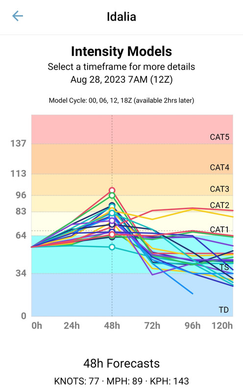
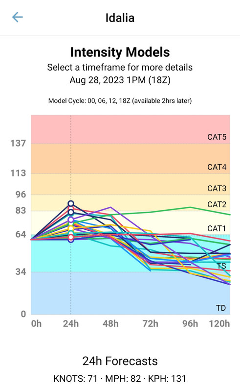
Interestingly enough the intensity models turned weaker with the latest runs.
Posted on 8/28/23 at 4:07 pm to lsuman25
quote:
Middle of Longboat Key, FL to Englewood, FL...3-5 ft
That's me!
Posted on 8/28/23 at 4:22 pm to SippyCup
This thing gonna be hitting Apalachicola at this rate, another shift to the NW
Posted on 8/28/23 at 4:29 pm to lsuman25
quote:
I would not be shocked to see Idalia shift east. Look at the clouds way north of the storm moving off to the North East
That’s not really how this works.
Posted on 8/28/23 at 4:34 pm to CE Tiger
Confirmed—Cantore to Cedar Key: Pensacola News-Journal

Posted on 8/28/23 at 4:38 pm to RockChalkTiger
quote:
Cantore to Cedar Key
time to pick up my all weather jorts from the dry cleaners

Posted on 8/28/23 at 4:44 pm to Slagathor
Thanks to my meteorology degree from John Melvin University, I can confirm Idalia will make landfall in Florida.
Posted on 8/28/23 at 4:46 pm to Jwho77
quote:
Thanks to my meteorology degree from John Melvin University, I can confirm Idalia will make landfall in Florida.
Posted on 8/28/23 at 4:54 pm to Slagathor
quote:
time to pick up my all weather jorts from the dry cleaners
I cant remember exactly where you are, but if its coming your way...
dont frick around.
The ceiling is HIGH for this one.
Posted on 8/28/23 at 4:57 pm to Duke
Duke - what’s the worst case scenario strength wise in your opinion?
Posted on 8/28/23 at 4:58 pm to Jwho77
Posted on 8/28/23 at 4:59 pm to RockChalkTiger

Posted on 8/28/23 at 5:01 pm to LegendInMyMind
So why do the intensity models show Cat 1 when all the operational models are showing a 2 at minimum?
Posted on 8/28/23 at 5:03 pm to deltaland
No idea. Just watching to see what they spit out.
Posted on 8/28/23 at 5:05 pm to Duke
quote:
I cant remember exactly where you are, but if its coming your way...
dont frick around.
Funny you say that because I've done a surprising amount of fricking around in comparison to the amount of finding out
But I do always prep accordingly, and I should hopefully be okay here in Gainesville


 Page 76 of 139

Popular
Back to top