- My Forums
- Tiger Rant
- LSU Recruiting
- SEC Rant
- Saints Talk
- Pelicans Talk
- More Sports Board
- Fantasy Sports
- Golf Board
- Soccer Board
- O-T Lounge
- Tech Board
- Home/Garden Board
- Outdoor Board
- Health/Fitness Board
- Movie/TV Board
- Book Board
- Music Board
- Political Talk
- Money Talk
- Fark Board
- Gaming Board
- Travel Board
- Food/Drink Board
- Ticket Exchange
- TD Help Board
Customize My Forums- View All Forums
- Show Left Links
- Topic Sort Options
- Trending Topics
- Recent Topics
- Active Topics
Started By
Message
re: Hurricane Season - TS Paulette, TS Rene, 95L, 96L & Fruit Salad
Posted on 8/30/20 at 10:39 am to JudgeHolden

Posted on 8/30/20 at 10:39 am to JudgeHolden
Wait until after you cut the grass.
 0
0

Posted on 8/30/20 at 10:42 am to Duke
quote:
Get there and thinking MJO progression could lead to a little lull in activity late September too.
Brief explanation?
TIA
Posted on 8/30/20 at 10:43 am to Paul Allen
AND,.......
I’m Shteve Gheller
Double U Dub L
Shports
I’m Shteve Gheller
Double U Dub L
Shports

Posted on 8/30/20 at 10:44 am to BRgetthenet

Posted on 8/30/20 at 10:45 am to fishfighter
quote:
More then happy to get some cool weather.
I don't think it's one of THOSE cool fronts. It's the kind we get this time of year that dries things out and it only gets to 87 instead of 92.
I'll take it, but it ain't the "wake up in the morning and realize that noise you hear is the air conditioner not running and open the windows because the eight months of miserable weather in this godforsaken state is over" kind of front.
This post was edited on 8/30/20 at 10:48 am

Posted on 8/30/20 at 10:48 am to TulaneLSU
Friend,
The screen shot that you posted was a pleasant surprise. Congratulations on another brush with a celebrity! In reading the message from Mr Arredondo, I realized the great meteorologistic horsepower that was assembled for a while at WorldWideLoyola TV for that period: Nash (who moved into the emeritus rôle), Mr David Barnes, and our Mr Arredondo. Quite impressive, I dare say no other local station in the United States could compare with that lineup. Conversely stated, one would have to get up Early to have a better lineup? And unfortunately, he’s now the late Mr Early.
Wishing to you and yours a pleasant Sabbath and thank you again for your work here, I remain your humble correspondent.
Yours truly,
Mssr. Füt
This post was edited on 8/30/20 at 10:56 am

Posted on 8/30/20 at 10:58 am to Duke
quote:
MJO progression
Have we crossed over the peak of the current cycle yet?
I'm looking at the chart below and am having a hell of a time trying to read it.
Is zone 8 the typical danger zone for the North Atlantic region?
Or is the distance from the center the largest indicator of the cycle potential?
And in general how much does the MJO play as a factor in tropical storm development potential?
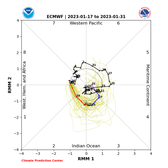
Sorry for the barrage of questions, but I went down an MJO rabbit hole last night.
Posted on 8/30/20 at 11:13 am to PurpleGoldTiger
quote:
I'm looking at the chart below and am having a hell of a time trying to read it.
Why? That graph isn't straightforward enough?
quote:
Is zone 8 the typical danger zone for the North Atlantic region?
8, 1, and 2 are typically better for tropical development.
quote:
Or is the distance from the center the largest indicator of the cycle potential?
Distance from center is how strong the pulse is. Too strong and you might get too much competing convection. It's a lot more where in the cycle it is vs how strong imo.
quote:
And in general how much does the MJO play as a factor in tropical storm development potential?
It's a table setter that tells you convection should be enhanced and conditions for tropical systems will be more favorable. Still can have colder water temps or dry air wreck it.
This tweet is a great way to visualize it. Green = stormier.
LINK
Posted on 8/30/20 at 11:23 am to Duke
quote:
Why? That graph isn't straightforward enough?
NO way. There's NO way I'm diving into this one. Have at it, Duke. And Godspeed.
Madden is generally okay. It was that a-hole Julian who strongly favored the use of impossible graphs.
This post was edited on 8/30/20 at 11:26 am

Posted on 8/30/20 at 11:26 am to TigerstuckinMS
quote:
It's the kind we get this time of year that dries things out and it only gets to 87 instead of 92.
The weather channel is predicting high 79 low 62 around 9/11. I’ll take it!!
Posted on 8/30/20 at 11:33 am to CoachChappy
Hell even if we get a high of 85 and a low in the 60’s with low humidity, I will be damn happy
Posted on 8/30/20 at 11:50 am to Duke
quote:
It's a table setter that tells you convection should be enhanced and conditions for tropical systems will be more favorable. Still can have colder water temps or dry air wreck it.
So going by the projections on the graph, it looks like we're in the downswing of the cycle and entering zone 3. I'll absolutely take one less table setter at this point in the season.
quote:
This tweet is a great way to visualize it. Green = stormier.
Mr. Webb just got a follow, that was great. Thanks again for the info.
quote:
Madden is generally okay. It was that a-hole Julian who strongly favored the use of impossible graphs.

Posted on 8/30/20 at 11:52 am to rds dc
After multiple days of heat indexes reaching 115 here in DFW, can we please just skip fall and go right into winter??
Posted on 8/30/20 at 2:28 pm to rds dc
Sounds like The Gulf may be closed for a while then ? I don't count storms that form in the NW carribbean and move northeast of the Florida straits. I mean major hurricanes that make it north to upper texas coast to Mobile, Alabama.
Seems like a storm moving north to central Gulf Coast in late September usually circulates drier continental air into its circulation before landfall.
Seems like a storm moving north to central Gulf Coast in late September usually circulates drier continental air into its circulation before landfall.
Posted on 8/30/20 at 2:35 pm to Klingler7
quote:
Seems like a storm moving north to central Gulf Coast in late September usually circulates drier continental air into its circulation before landfall.
Yeah that's normally how it goes and by late September the mid latitudes are starting to get more active and open up the Bermuda high to have right turns out of the area.

Posted on 8/30/20 at 2:44 pm to TulaneLSU
quote:

Posted on 8/30/20 at 2:54 pm to rds dc
quote:

Polar vortex setting up shop a little early.

Posted on 8/30/20 at 3:28 pm to Tarps99
quote:Not early enough for this cowboy. Just happened to glance at the 10 day forecast, and we're sunny, mid 90s, and heat indices well over triple digits for the next week. In other words, it'll be hot as balls out there this week.
Polar vortex setting up shop a little early.
Posted on 8/30/20 at 11:43 pm to rds dc
Man I sure wouldn't mind that cold arse winter we got a few years back where it snowed like 6 inches in Louisiana then a few weeks later iced over. This is one hot dry arse summer.
Posted on 8/31/20 at 7:26 am to rds dc
quote:
Need to get through the next week or so and then the 1st cold front of the season should shut the Gulf down for a bit.
Thank you !

 Page 2 of 11

Popular
Back to top