- My Forums
- Tiger Rant
- LSU Recruiting
- SEC Rant
- Saints Talk
- Pelicans Talk
- More Sports Board
- Fantasy Sports
- Golf Board
- Soccer Board
- O-T Lounge
- Tech Board
- Home/Garden Board
- Outdoor Board
- Health/Fitness Board
- Movie/TV Board
- Book Board
- Music Board
- Political Talk
- Money Talk
- Fark Board
- Gaming Board
- Travel Board
- Food/Drink Board
- Ticket Exchange
- TD Help Board
Customize My Forums- View All Forums
- Show Left Links
- Topic Sort Options
- Trending Topics
- Recent Topics
- Active Topics
Started By
Message

Hurricane Florence - Information and Resources
Posted on 9/10/18 at 6:05 pm

Posted on 9/10/18 at 6:05 pm
This thread contains an agglomeration of information and resources for those likely to be impacted by Hurricane Florence. I will try my best to keep this thread as updated as possible. Feel free to make content suggestions. Post 2 in this thread will have further information. 
Useful Links
I-95, I-40 closed near Fayetteville and Wilmington
NC Flood Inundation Mapping and Alert Network
NC Flood Maps
Weather Information
National Weather Service - Hurricane Florence
Official NHC Track

NHC Public Advisory

NHC Forecast Discussion

WPC Rainfall Predictions
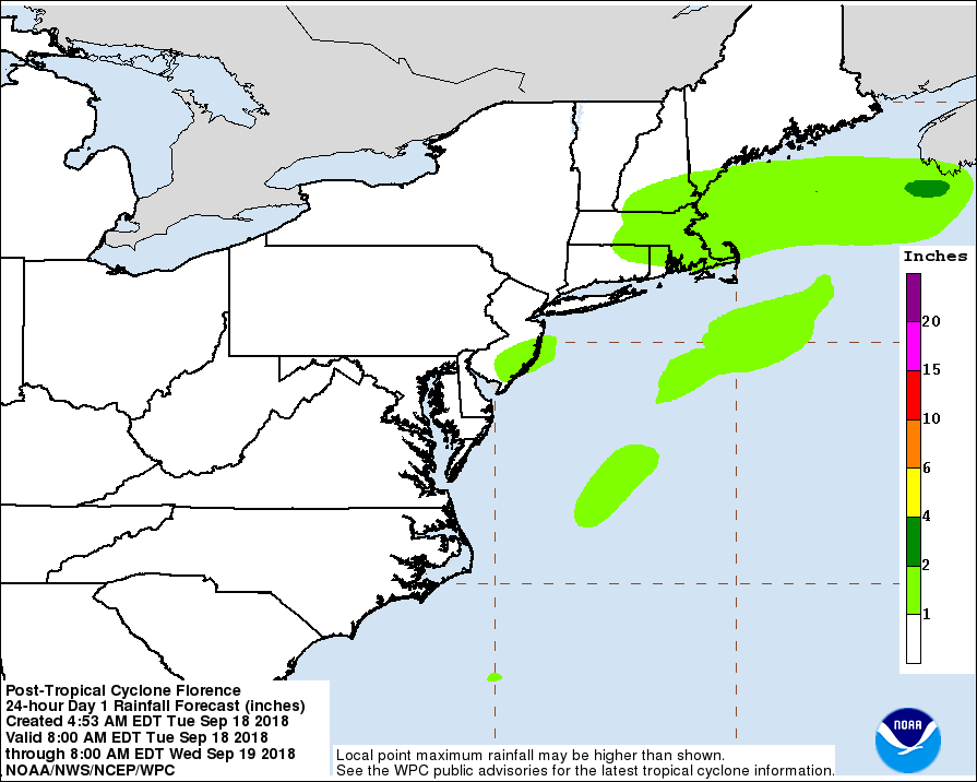

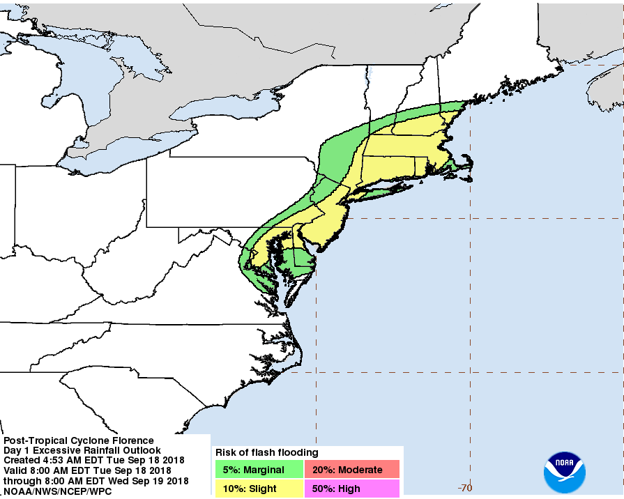
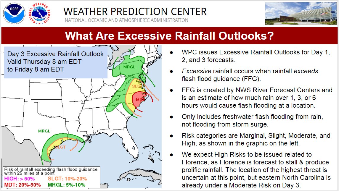
Chart of Arrival Time of Tropical-Storm-Force Winds

NOAA: Interactive National Storm Surge Hazard Map
LINK ]
WPC Mesoscale Discussions


SPC Mesoscale Discussions
Emergency Management Agencies
FEMA
North Carolina Emergency Management
South Carolina Emergency Management
Maryland Emergency Management
Virginia Emergency Management
Twitter
NWS
NHC Atlantic
NHC Surge
NOAA
FEMA
FEMA Region 4
ReadyGov
NCDOT
NC Public Safety
NC Governor
NC Emergency Management
NWS Wilmington
NWS Morehead City
NWS Raleigh
NWS Charleston
NWS Wakefield
NWSWPC
National Weather Service Offices - Websites
All NWS Offices
Charleston
Wilmington
Newport/Morehead City
Raleigh
Wakefield
Evacuation Routes
North Carolina
South Carolina
Sandbag Locations
Charleston and Dorcester Counties - Sandbag Locations
Apps and Alerts
FEMA App
ReadyNC App
Ready.gov Emergency Alerts
CharMeckAlerts - Charlotte Alert System
Local TV
Wilmington ABC/CBS | Watch Live
Charleston ABC | Watch Live
Raleigh CBS | Watch Live
WTOP
Videos (Weather Updates and Live Cams)
Levi Cowan's YouTube Channel - Tropical Tidbits
Live Streams List With Links
More Useful Links
Should I Evacuate? Slackster's Choose Your Own Adventure
Latest Briefing Explanatory PowerPoint - Updates Regularly
Latest States of Emergency, Curfews, Gas Shortages, etc.
Evacuation Considerations
Thread on Travel Board About Air Travel and Airline Waivers
FEMA - Hurricane Florence Preparedness
Weather.gov - Watches and Warnings
Flood Insurance Tips by Poster Dlab2013
Crown Weather
Find Your Evacuation Zone
Windy
GA - State of Emergency for All Counties
Useful Links
I-95, I-40 closed near Fayetteville and Wilmington
NC Flood Inundation Mapping and Alert Network
NC Flood Maps
Weather Information
National Weather Service - Hurricane Florence
Official NHC Track
NHC Public Advisory
NHC Forecast Discussion
WPC Rainfall Predictions
Chart of Arrival Time of Tropical-Storm-Force Winds
NOAA: Interactive National Storm Surge Hazard Map
LINK ]
WPC Mesoscale Discussions
SPC Mesoscale Discussions
Emergency Management Agencies
FEMA
North Carolina Emergency Management
South Carolina Emergency Management
Maryland Emergency Management
Virginia Emergency Management
NWS
NHC Atlantic
NHC Surge
NOAA
FEMA
FEMA Region 4
ReadyGov
NCDOT
NC Public Safety
NC Governor
NC Emergency Management
NWS Wilmington
NWS Morehead City
NWS Raleigh
NWS Charleston
NWS Wakefield
NWSWPC
National Weather Service Offices - Websites
All NWS Offices
Charleston
Wilmington
Newport/Morehead City
Raleigh
Wakefield
Evacuation Routes
North Carolina
South Carolina
Sandbag Locations
Charleston and Dorcester Counties - Sandbag Locations
Apps and Alerts
FEMA App
ReadyNC App
Ready.gov Emergency Alerts
CharMeckAlerts - Charlotte Alert System
Local TV
Wilmington ABC/CBS | Watch Live
Charleston ABC | Watch Live
Raleigh CBS | Watch Live
WTOP
Videos (Weather Updates and Live Cams)
Levi Cowan's YouTube Channel - Tropical Tidbits
Live Streams List With Links
More Useful Links
Should I Evacuate? Slackster's Choose Your Own Adventure
Latest Briefing Explanatory PowerPoint - Updates Regularly
Latest States of Emergency, Curfews, Gas Shortages, etc.
Evacuation Considerations
Thread on Travel Board About Air Travel and Airline Waivers
FEMA - Hurricane Florence Preparedness
Weather.gov - Watches and Warnings
Flood Insurance Tips by Poster Dlab2013
Crown Weather
Find Your Evacuation Zone
Windy
GA - State of Emergency for All Counties
This post was edited on 9/17/18 at 9:06 pm
 26
26

Posted on 9/10/18 at 6:06 pm to When in Rome
North Carolina Emergency Information and Reports
English & Spanish: 888-835-9966
Hearing Impaired: 800-735-8262
North Carolina Emergency Management: 919-825-2500
North Carolina Department of Public Safety - Florence Page
Onslow Emergency Services Facebook Page
Call 211 or 888-892-1162 for shelters, food assistance, and storm recovery help.
Visit DriveNC.gov and NCDOT.gov for road conditions and travel information.
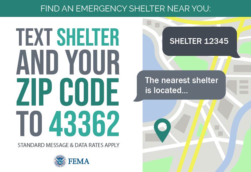
Shelter Information
Charlotte
Camp Lejeune & MCAS New River
Onslow County
New Hanover County Shelter
Johnston County
Carteret County
Gas Leaks
PSNC 1-877-776-2427.
Rocky Mounty Utility 252-467-4800
Wilson Energy 252-399-2432
Greenville Utility: 1-855-767-2482
Electricity
NC Electric Cooperatives
Duke Energy: 1-800-POWERON (1-800-769-3766) – Outage Map
Four County Electric
Telephone
AT&T: 800-288-2020
CenturyLink: 800-672-6242
Verizon: 800-483-1000, Spanish 800-743-2483
South Carolina Emergency Information and Reports
South Carolina Emergency Management: 803-737-8500
Electricity
SCE&G: 888-333-4465
Santee Cooper: 888-769-7688
Duke Power: 800-769-3766
SC Electric Co-ops:
Aiken Electric Cooperative: 1-877-264-5368 or 1-803-649-6245 or 1-800-922-1262
Berkeley Electric Cooperative: 1-888-253-4232
Black River Electric Cooperative: Sumter- 1-803-469-8060 or Camden- 1-803-432-9854
Blue Ridge Electric Cooperative: 1-888-258-3743
Broad River Electric Cooperative: Cherokee County- 1-864-489-5738 or Other Counties- 1-866-266-7688
Coastal Electric Cooperative: 1-843-538-5800
Edisto Electric Cooperative: 1-800-433-3292
Fairfield Electric Cooperative: 1-800-499-7862
Horry Electric Cooperative: 1-843-369-2212
Laurens Electric Cooperative: 1-800-942-3141
Little River Electric Cooperative: 1-800-459-2141 or 366-2141
Lynches River Electric Cooperative: 1-866-675-5732
Marlboro Electric Cooperative: 1-843-479-3855 or 1-800-922-9174
Mid-Carolina Electric Cooperative: 1-803-749-6444 or 1-888-813-7000
Newberry Electric Cooperative: 1-803-276-1121
Palmetto Electric Cooperative: 1-866-445-5551
Pee Dee Electric Cooperative: 1-843-665-4070 or 1-866-747-0060
Santee Electric Cooperative: 1-888-239-2300
Tri-County Electric Cooperative: 1-803-874-1215 or 1-877-874-1215
York Electric Cooperative: 1-866-374-1234
Georgia Emergency Information and Reports
Georgia Emergency Management & Homeland Security Agency
GeorgiaDOT Twitter
Georgia EM & HS Twitter
Georgia State Parks, including campsites and cottages, are open to evacuees. Georgia State Parks will not be turning away any visitors seeking assistance.
All cabins will be allowed to accommodate domestic pets. Pet fees will be waived during this weather event.
Parks that currently have overnight equestrian facilities will allow visitors traveling with horses to use portable corrals and high lines (with tree saver straps). AH Stephens State Park will utilize the event field as an overflow for their equestrian campground.
For information about parks, updates and how to rent facilities please click here.
The Atlanta Motor Speedway camping facilities are open for evacuees seeking refuge from Hurricane Florence. Campgrounds utilized will be Legends for dry camping and Premium (main entrance road) for hook-ups.
More information can be found here.
Georgia Department of Agriculture has temporarily suspended interstate movement requirements for animals evacuating from Virginia, North Carolina, and South Carolina. Visit the Ga. Department of Agriculture website? for more information.
We are monitoring fuel supplies across the state, and there are no fuel shortages reported at this time.
Virginia Emergency Information and Reports
Virginia Department of Emergency Management
Electricity
Dominion Energy- Virginia
Transportation
VDOT- VA Department of Transportation
Virginia Know Your Zone Map
Maryland Emergency Information and Reports
Maryland Emergency Management
Department of City Services: 3-1-1
Electricity
PEPCO
BGE
This post was edited on 9/13/18 at 10:57 am

Posted on 9/10/18 at 6:08 pm to When in Rome
Local TV Coverage / Watch Live when available
Wilmington ABC/CBS
Watch Live
Releigh CBS
Watch Live
Greenville, North Carolina (East Carolina) NBC
Watch Live
Charlotte CBS
Watch Live
Charleston ABC
Watch Live
Wilmington ABC/CBS
Watch Live
Releigh CBS
Watch Live
Greenville, North Carolina (East Carolina) NBC
Watch Live
Charlotte CBS
Watch Live
Charleston ABC
Watch Live
This post was edited on 9/10/18 at 6:32 pm

Posted on 9/10/18 at 6:10 pm to When in Rome
Thanks
I'm far enough away from the coast but probably need to think about getting out of here because it looks like I'm in one of the heavy projected rainfall areas
And it's been raining here a lot already so I'm expecting a lot of flooding
I'm far enough away from the coast but probably need to think about getting out of here because it looks like I'm in one of the heavy projected rainfall areas
And it's been raining here a lot already so I'm expecting a lot of flooding
Posted on 9/10/18 at 6:10 pm to LaBR4
Thanks added to OP.
Posted on 9/10/18 at 6:11 pm to Powerman
Stay safe ... I hate that this has to go anywhere.
Posted on 9/10/18 at 6:11 pm to When in Rome
This thread needs a sticky!
Posted on 9/10/18 at 6:12 pm to tiger91
I think I'm going to head west and get a hotel in Nashville or the surrounding area. That should be far enough away.
Posted on 9/10/18 at 6:12 pm to When in Rome
quote:
Thanks added to OP.
Just added the direct live stream feeds under the homepage for each for when available.
This post was edited on 9/10/18 at 6:13 pm

Posted on 9/10/18 at 6:14 pm to When in Rome
quote:Damn, we getting high class verbiage up in here.
agglomeration
Posted on 9/10/18 at 6:15 pm to LaBR4
quote:Awesome, thanks!
Just added the direct live stream feeds under the homepage for each for when available.
Posted on 9/10/18 at 6:15 pm to When in Rome
Got all of the links I would have included.
I'm going to be perusing NWS station discussions and posting relevant ones in this post via edit. Additionally, I'll be linking any mesoscale discussions from the WPC and SPC (tornadoes) as the storm gets rolling. Though I will be flying out west Thursday, so my updates will be sporadic on that front.
***WIR, throw this part in the OP under track.
NHC Public Advisory
NHC Forecast Discussion
I'm going to be perusing NWS station discussions and posting relevant ones in this post via edit. Additionally, I'll be linking any mesoscale discussions from the WPC and SPC (tornadoes) as the storm gets rolling. Though I will be flying out west Thursday, so my updates will be sporadic on that front.
***WIR, throw this part in the OP under track.
NHC Public Advisory
quote:
Hurricane Florence Advisory Number 47
NWS National Hurricane Center Miami FL AL062018
1100 PM AST Mon Sep 10 2018
...FLORENCE CHANGES LITTLE IN STRENGTH DURING THE PAST SEVERAL
HOURS...
...HURRICANE AND STORM SURGE WATCHES LIKELY TO BE ISSUED ON
TUESDAY...
SUMMARY OF 1100 PM AST...0300 UTC...INFORMATION
-----------------------------------------------
LOCATION...25.9N 62.4W
ABOUT 465 MI...750 KM SSE OF BERMUDA
ABOUT 1085 MI...1745 KM ESE OF CAPE FEAR NORTH CAROLINA
MAXIMUM SUSTAINED WINDS...140 MPH...220 KM/H
PRESENT MOVEMENT...WNW OR 290 DEGREES AT 13 MPH...20 KM/H
MINIMUM CENTRAL PRESSURE...944 MB...27.88 INCHES
WATCHES AND WARNINGS
--------------------
There are no coastal watches or warnings in effect.
Interests in the southeastern and mid-Atlantic states should monitor
the progress of Florence. Storm Surge and Hurricane watches are
likely be issued for portions of these areas on Tuesday.
DISCUSSION AND OUTLOOK
----------------------
At 1100 PM AST (0300 UTC), the center of Hurricane Florence was
located near latitude 25.9 North, longitude 62.4 West. Florence is
moving toward the west-northwest near 13 mph (20 km/h). A west-
northwestward to northwestward motion and an increase in forward
speed are expected during the next couple of days. On the forecast
track, the center of Florence will move over the southwestern
Atlantic Ocean between Bermuda and the Bahamas Tuesday and
Wednesday, and approach the coast of North Carolina or South
Carolina on Thursday.
Maximum sustained winds are near 140 mph (220 km/h) with higher
gusts. Florence is a category 4 hurricane on the Saffir-Simpson
Hurricane Wind Scale. Some strengthening is expected during the
next 36 hours, and Florence is expected to be an extremely dangerous
major hurricane through Thursday.
Hurricane-force winds extend outward up to 40 miles (65 km) from the
center and tropical-storm-force winds extend outward up to 150 miles
(240 km).
The latest minimum central pressure estimated from Air Force
Reserve Hurricane Hunter aircraft data is 944 mb (27.88 inches).
HAZARDS AFFECTING LAND
----------------------
SURF: Swells generated by Florence are affecting Bermuda and
portions of the U.S. East Coast. These swells are likely to cause
life-threatening surf and rip current conditions. Please consult
products from your local weather office.
NEXT ADVISORY
-------------
Next complete advisory at 500 AM AST.
$$
Forecaster Beven
NHC Forecast Discussion
quote:
Hurricane Florence Discussion Number 47
NWS National Hurricane Center Miami FL AL062018
1100 PM AST Mon Sep 10 2018
The rapid intensification of Florence ended just after the last
advisory, with the central pressure falling to near 939 mb. Since
that time, the eyewall convection has become a bit ragged and the
latest central pressure from the Air Force Reserve Hurricane Hunter
aircraft is near 944 mb. The initial intensity will remain a
possibly generous 120 kt for this advisory based on the aircraft
winds. Microwave imagery suggests that Florence may be starting an
eyewall replacement cycle. However, the winds from the Hurricane
Hunter did not clearly indicate the presence of an outer eyewall.
Florence should remain in a light shear environment and over sea
surface temperatures near 29C for at least the next 48 h. Thus,
there is little other than eyewall replacement cycles to keep the
hurricane from intensifying further as indicated by all of the
intensity guidance. The new intensity forecast calls for continued
strengthening to near category 5 strength, although at a slower rate
than what occurred during the last 30 h. Florence is expected to
encounter southwesterly shear near the 72 h point, which could
cause slight weakening before landfall. However, there remains high
confidence that Florence will be a large and extremely dangerous
hurricane, regardless of its exact intensity.
The initial motion is 290/11. A building mid-level ridge over the
northwestern Atlantic is expected to steer Florence
west-northwestward to northwestward with an increase in forward
speed during the next 48 h. After that time, a marked decrease in
forward speed is likely as another ridge builds over the Great
Lakes to the north of Florence. The track guidance continues to
show some spread between the ECMWF on the left side of the envelope
and the GFS on the right side. Overall, though, the guidance has
again shifted a little to the right, and the 72-96 h points are
nudged just a little to the right from the previous forecast. It is
important not to focus on the exact forecast track as average NHC
errors at days 3, 4, and 5 are about 100, 140 and 180 n mi,
respectively, and dangerous hazards will extend well away from the
center.
The NOAA G-IV jet will continue to conduct synoptic surveillance
missions every 12 h through at least Wednesday. In addition, special
0600 UTC and 1800 UTC radiosonde launches have been expanded to
additional upper-air stations across the U.S. to collect extra data
for the numerical models. The next Air Force Reserve Hurricane
Hunter mission into Florence is scheduled for near 12Z.
Key Messages:
1. A life-threatening storm surge is likely along portions of the
coastlines of South Carolina, North Carolina, and Virginia, and
a Storm Surge Watch will likely be issued for some of these areas by
Tuesday morning. All interests from South Carolina into the mid-
Atlantic region should ensure they have their hurricane plan in
place and follow any advice given by local officials.
2. Life-threatening freshwater flooding is likely from a prolonged
and exceptionally heavy rainfall event, which may extend inland over
the Carolinas and Mid Atlantic for hundreds of miles as Florence is
expected to slow down as it approaches the coast and moves inland.
3. Damaging hurricane-force winds are likely along portions of the
coasts of South Carolina and North Carolina, and a Hurricane Watch
will likely be issued by Tuesday morning. Damaging winds could also
spread well inland into portions of the Carolinas and Virginia.
4. Large swells affecting Bermuda and portions of the U.S. East
Coast will continue this week, resulting in life-threatening surf
and rip currents.
FORECAST POSITIONS AND MAX WINDS
INIT 11/0300Z 25.9N 62.4W 120 KT 140 MPH
12H 11/1200Z 26.5N 64.5W 125 KT 145 MPH
24H 12/0000Z 27.9N 67.5W 130 KT 150 MPH
36H 12/1200Z 29.6N 70.4W 135 KT 155 MPH
48H 13/0000Z 31.3N 73.2W 130 KT 150 MPH
72H 14/0000Z 34.0N 76.5W 120 KT 140 MPH
96H 15/0000Z 35.5N 78.0W 50 KT 60 MPH...INLAND
120H 16/0000Z 36.5N 79.0W 25 KT 30 MPH...INLAND
$$
Forecaster Beven
This post was edited on 9/10/18 at 9:58 pm
Posted on 9/10/18 at 6:16 pm to Duke
quote:
I'm going to be perusing NWS station discussions and posting relevant ones in this post via edit. Additionally, I'll be linking any mesoscale discussions from the WPC and SPC (tornadoes) as the storm gets rolling. Though I will be flying out west Thursday, so my updates will be sporadic on that front.


Posted on 9/10/18 at 6:16 pm to When in Rome
Good job OP
Posted on 9/10/18 at 6:18 pm to When in Rome
quote:
Hurricane Florence - Information and Resources by When in Rome
Posted on 9/10/18 at 6:18 pm to FCP
quote:
agglomeration
Damn, we getting high class verbiage up in here.
OP needs to link a dictionary too.

Posted on 9/10/18 at 6:21 pm to When in Rome
Much respect to the OP. That took a lot of work.

Posted on 9/10/18 at 6:21 pm to When in Rome
I’ve got my popcorn ready.
Posted on 9/10/18 at 6:21 pm to When in Rome
Checking in. Hurricane is currently on path to go directly over my town
Posted on 9/10/18 at 6:23 pm to 13SaintTiger
what town?

 Page 1 of 11

Popular
Back to top