- My Forums
- Tiger Rant
- LSU Recruiting
- SEC Rant
- Saints Talk
- Pelicans Talk
- More Sports Board
- Fantasy Sports
- Golf Board
- Soccer Board
- O-T Lounge
- Tech Board
- Home/Garden Board
- Outdoor Board
- Health/Fitness Board
- Movie/TV Board
- Book Board
- Music Board
- Political Talk
- Money Talk
- Fark Board
- Gaming Board
- Travel Board
- Food/Drink Board
- Ticket Exchange
- TD Help Board
Customize My Forums- View All Forums
- Show Left Links
- Topic Sort Options
- Trending Topics
- Recent Topics
- Active Topics
Started By
Message
re: Helene - Recovery Begins...Devastating Flash Flooding in Western NC and Eastern TN
Posted on 9/22/24 at 7:25 pm to RummelTiger
Posted on 9/22/24 at 7:25 pm to RummelTiger
quote:
33ft above surface.
From the top of the crest of the waves or the bottom?
 0
0

Posted on 9/22/24 at 7:26 pm to Duke
quote:
This gonna be a big (size) storm it looks like.
GFS showing hurricane winds upon approach that are 140 miles across
Posted on 9/22/24 at 7:32 pm to PhillyTiger90
quote:
Not comfortable that Florida is the target 5-7 days out. Almost always will move one way or another and any H shift west will be bad news
IIRC Michael was spun up in a similar way and they absolutely nailed that forecast from the get go.
Posted on 9/22/24 at 7:38 pm to beachdude
quote:
South Walton County has been lucky for over 50 years as far as winds are concerned. Storm surge/high surf in Opal,
Wasn’t Opal a Cat3 major with 145mph gusts over at Eglin AFB?
My understanding is that was a beast with major property damage at a time when the area was probably 1/4 as populated / built up, but that was before my time so i definitely defer to you on that one.
This post was edited on 9/22/24 at 7:48 pm
Posted on 9/22/24 at 7:39 pm to PhillyTiger90
quote:
Not comfortable that Florida is the target 5-7 days out
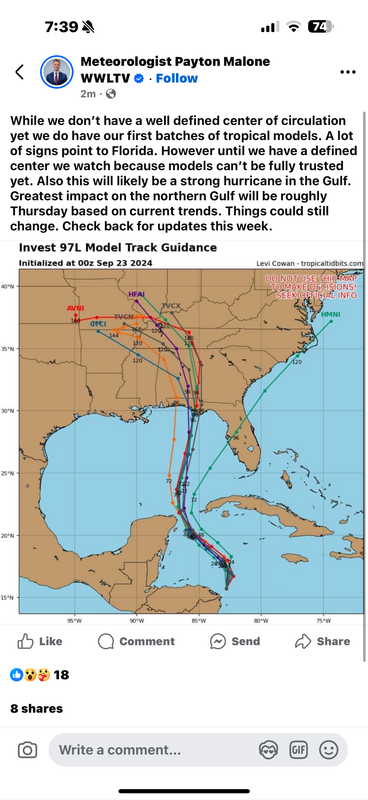
It is much sooner than that. Landfall is likely to be in about 84-96 hours from now and the outer bands will be getting to the coastline about 10 to 12 hours before that (very late Wednesday or early Thursday morning.
So it is really about 3 to 3.5 days from impact.
Posted on 9/22/24 at 7:45 pm to slackster
I went through Michael in Mexico beach. We didn't know it was cat five until about 12 hrs before landfall. All week long they were saying 1,2,or 3. I remember getting the alert on my phone at 1am saying 176 mph winds gusting to 197. Needless to say it was a hell of a day
Posted on 9/22/24 at 7:46 pm to slackster
quote:
IIRC Michael was spun up in a similar way and they absolutely nailed that forecast from the get go.
I agree they were very close on landfall (Tyndall AFB / Mexico Beach vs 30A), but I thought they were slow to pickup on the potential for rapid intensification?
I was down there 2-3 days before landfall and most people who weren’t tracking on the TD thread had no idea that thing was about to explode. The experts on here made me sound like Nostradamus when I kept telling people it could be a really bad storm that week.
Posted on 9/22/24 at 7:46 pm to JS87
I hope that people there are paying attention .. defined center or not I’d be puckered if I lived there.
Posted on 9/22/24 at 7:47 pm to tide06
Once again I follow here wayyyyy more than tv. For local updates while happening sure. But for picking these things up and watching as they develop, here’s the best bet.
Posted on 9/22/24 at 7:50 pm to tide06
Friend,
Opal was relatively compact with its hurricane force winds. Our place east of Destin had minimal damage, with estimated winds only reaching 50-60mph in our section of 30-A. Opal was also trucking NE very quickly, so winds did not last long. Devastated the Navarre to Fort Walton area, and the dunes east of FWB are still recovering.
Our first ride over to east of Destin was two months later and eye opening. After a Herculean effort to rebuild 98 on Okaloosa Island, they had 98 opened in about three or four weeks. But that first ride I can still remember with my 11 year old eyes being amazed that the 30-40 foot dunes were gone, reduced to a flat beach.30A saw nothing like that and the dunes there were unscathed.
I believe Bob Breck was the only NOLA meteorologist warning New Orleanians to pay attention. Had that track shift just a few degrees north while it was a weak storm in the Gulf, the city would have been in big trouble. It was cavalier of the perpetually suspect NWS to write off chances of it damaging the city. It still produced some tropical storm force winds in the city. Think it was the day of the O.J. Simpson verdict too. They were exciting times.
Thankfully the legend Bruce Katz had taken the mantle from Breck and we can sleep well knowing one of the few invested and intelligent meteorologists has our back.
Yours,
TulaneLSU
Posted on 9/22/24 at 7:50 pm to tiger91
i fear this is going to be a retire the name level storm
Posted on 9/22/24 at 7:51 pm to tide06
quote:
Opal…Eglin
Don’t remember where Opal came ashore, but it wasn’t 30A. Eglin is in Okaloosa County. There was definitely beachfront wave scouring in Walton County and 30A was washed out at a low spot near Santa Rosa Beach Country Club, but wind damage was minimal to nonexistent. (Opal made landfall between Pensacola and Navarre.)
This post was edited on 9/22/24 at 7:55 pm
Posted on 9/22/24 at 7:52 pm to tiger91
quote:
I hope that people there are paying attention .. defined center or not I’d be puckered if I lived there.
They aren’t yet from what I’ve seen.
I think the fact that it was supposed to be a Saturday issue that’s now a Thursday landfall is going to cause the shite to hit the fan starting tomorrow when news starts to get out.

Posted on 9/22/24 at 7:54 pm to rds dc
I have an airbnb house in Perdido Key, and some guests that are arriving on Thursday. Do y'all think its too early to cancel their reservation or do I need to wait a bit longer?
Posted on 9/22/24 at 7:54 pm to tide06
Welllll then go get what you need and avoid the madness.
Hoping for the best for everyone wherever this may go.
Hoping for the best for everyone wherever this may go.

Posted on 9/22/24 at 7:54 pm to beachdude
quote:
Don’t remember where Opal came ashore
Pensacola Beach...
Posted on 9/22/24 at 7:56 pm to tide06
quote:
I think the fact that it was supposed to be a Saturday issue that’s now a Thursday landfall is going to cause the shite to hit the fan starting tomorrow when news starts to get out
Are watching this one close as we leave late Friday night to drive to Orlando.
Thursday land fall would make for better weather for the drive but no telling what kind of road closures and other damage may affect traffic
Posted on 9/22/24 at 7:57 pm to CoonassatTEXAS
quote:
i fear this is going to be a retire the name level storm
There would be no doubt if it were an "I" storm.

 Page 40 of 310

Popular
Back to top