- My Forums
- Tiger Rant
- LSU Recruiting
- SEC Rant
- Saints Talk
- Pelicans Talk
- More Sports Board
- Fantasy Sports
- Golf Board
- Soccer Board
- O-T Lounge
- Tech Board
- Home/Garden Board
- Outdoor Board
- Health/Fitness Board
- Movie/TV Board
- Book Board
- Music Board
- Political Talk
- Money Talk
- Fark Board
- Gaming Board
- Travel Board
- Food/Drink Board
- Ticket Exchange
- TD Help Board
Customize My Forums- View All Forums
- Show Left Links
- Topic Sort Options
- Trending Topics
- Recent Topics
- Active Topics
Started By
Message
re: Helene - Recovery Begins...Devastating Flash Flooding in Western NC and Eastern TN
Posted on 9/22/24 at 5:24 pm to Paul Allen
Posted on 9/22/24 at 5:24 pm to Paul Allen
quote:
Don’t you also have a private meteorologist certification?
I have one that I found in a Cracker Jack Box after studying this board.
But in all seriousness, I do not have a degree in meteorology but love the field. I wouldn’t mind going back to school for a certificate of full degree if I had more time.
 0
0

Posted on 9/22/24 at 5:28 pm to RummelTiger
if you want give me 10 minutes as admin and I can really clean this place up.
And I promise to only ban like three people who don't deserve it
And I promise to only ban like three people who don't deserve it
Posted on 9/22/24 at 5:46 pm to X123F45
Stole this from @webberweather (Eric Webb) because I like it.
This is not a look that gives the warm and fuzzies.
This is not a look that gives the warm and fuzzies.

Posted on 9/22/24 at 5:47 pm to X123F45
quote:
if you want give me 10 minutes as admin and I can really clean this place up.
He’s gonna ignore you like he does me during baseball season
Posted on 9/22/24 at 5:49 pm to LSUJML
Amazing how time flies. Feels like it was just a couple weeks ago I left the dome only to find a potential major hurricane in the gulf days away.

Posted on 9/22/24 at 5:50 pm to RummelTiger
quote:
Only in private dancing…
What are you wearing?
Posted on 9/22/24 at 5:50 pm to ned nederlander
90% chance 20% chances become 100%
Posted on 9/22/24 at 5:50 pm to LegendInMyMind
quote:
Oof…
This post was edited on 9/22/24 at 5:51 pm
Posted on 9/22/24 at 5:50 pm to LegendInMyMind
Yeah if it can get an inner core developed before entering the Gulf look out
Posted on 9/22/24 at 5:53 pm to LegendInMyMind
That’s not scary at all
Posted on 9/22/24 at 6:09 pm to GeauxldMember
GFS Ensembles mostly coming into agreement on Gulf Shores to Big Bend with only a few possibilities outside of that. Timing in less in agreement. The image is for Thursday morning 7 AM CDT with many nearing landfall but another group still in east-central Gulf.

Posted on 9/22/24 at 6:12 pm to LegendInMyMind
Yikes.
This is gonna have a pretty high ceiling it looks like. Hope it doesnt reach its potential.
Posted on 9/22/24 at 6:18 pm to Duke
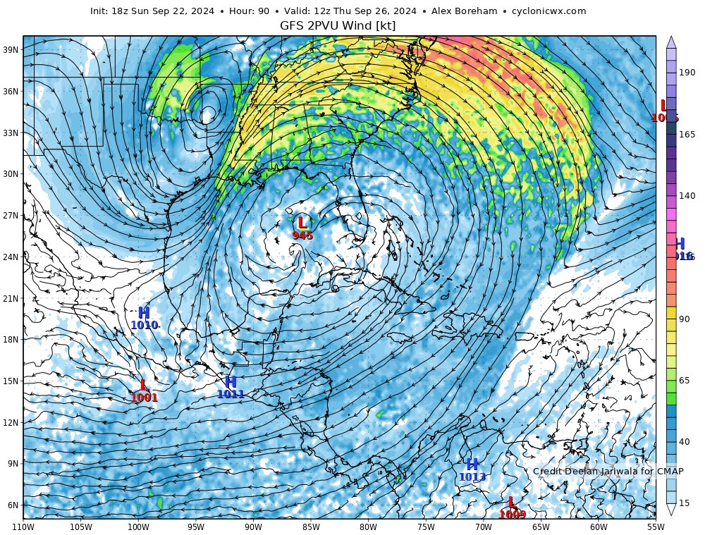
Can you ELI5 this image please? Is this showing 80 knot winds in Baton Rouge and nothing in the eye?
Posted on 9/22/24 at 6:22 pm to bnmathm
Those are the winds from like 35,000 feet above your head.
Posted on 9/22/24 at 6:31 pm to ticklechain
quote:
And we just got back to normal around here. I may be done after this
I think insurance will have a lot to say about that for many people depending on where this ends up.
Posted on 9/22/24 at 6:35 pm to Duke
quote:
Yikes. This is gonna have a pretty high ceiling it looks like. Hope it doesnt reach its potential.
Yikes is not what I want to hear from Duke as I’m sitting here on 30A.
Posted on 9/22/24 at 6:38 pm to tide06
It’s not going to be a well developed storm with strong winds.
Posted on 9/22/24 at 6:39 pm to tide06
With the way it’s been built up from gulf shores all the way thru 30a the insurance costs could be staggering and not good for coastal insurance
Hopefully a lot of these beachfront properties were built to sustain hurricanes
These areas have been very fortunate the last decade or so
Hopefully a lot of these beachfront properties were built to sustain hurricanes
These areas have been very fortunate the last decade or so
Posted on 9/22/24 at 6:42 pm to wasteland
quote:
It’s not going to be a well developed storm with strong winds
Thats a bold statement with the upper levels Im looking at.
Not that there arent some wrenches. TD in Pac will probably provide a little shear as it moves up. Maybe it doesnt organize as fast initially. But if you see that 2PVU map, youre concerned.
Posted on 9/22/24 at 6:49 pm to NorthEndZone
The first HMON run on 97L does not like Tampa.

 Page 38 of 310

Popular
Back to top