- My Forums
- Tiger Rant
- LSU Recruiting
- SEC Rant
- Saints Talk
- Pelicans Talk
- More Sports Board
- Fantasy Sports
- Golf Board
- Soccer Board
- O-T Lounge
- Tech Board
- Home/Garden Board
- Outdoor Board
- Health/Fitness Board
- Movie/TV Board
- Book Board
- Music Board
- Political Talk
- Money Talk
- Fark Board
- Gaming Board
- Travel Board
- Food/Drink Board
- Ticket Exchange
- TD Help Board
Customize My Forums- View All Forums
- Show Left Links
- Topic Sort Options
- Trending Topics
- Recent Topics
- Active Topics
Started By
Message
re: Francine - Landfall in Terrebonne Parish as CAT 2 100 mph
Posted on 9/11/24 at 11:36 am to Earthmover
Posted on 9/11/24 at 11:36 am to Earthmover
He was talking like he was back on the news...
 0
0


Posted on 9/11/24 at 11:36 am to OchoDedos
quote:
Sorry if the Tigerdroppings.com Chief Hurricane Forcasters got their feathers ruffled.
How to tell me you haven't paid attention to the Mets in this thread without telling me.
I mean this very sincerely. I check two places for tropics info:
1) RDS, duke, tboat
2) tropical tidbits
And these guys fricking kill it.
Posted on 9/11/24 at 11:36 am to OysterPoBoy
Posted on 9/11/24 at 11:36 am to OysterPoBoy
quote:Live Hurricane Tracker
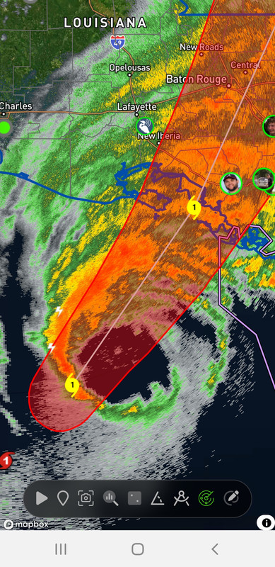
Does anyone have the current map that shows the line for the path?
Posted on 9/11/24 at 11:36 am to NorthEndZone
First moderate squall starting here in south Cut Off. Nothing more than a normal thunderstorm with wind gusting ~20 to 25.
Posted on 9/11/24 at 11:36 am to slackster
quote:
The Weather Company owns The Weather Channel and the GRAF model.
Yep. Also, tv stations are also contractually required to use it.They pay for this access. It’s absolutely a respectable model. However, it’s no coincidence that we see it shoved down our throats.
Posted on 9/11/24 at 11:36 am to LaLadyinTx
quote:
I think it goes directly over my parent's home near Siegen.
You need to look at more tracks then
Posted on 9/11/24 at 11:37 am to ChaseMac
Thanks for this link.

Posted on 9/11/24 at 11:38 am to Hulkklogan
quote:
I mean this very sincerely. I check two places for tropics info: 1) RDS, duke, tboat 2) tropical tidbits And these guys fricking kill it.


Posted on 9/11/24 at 11:38 am to rds dc
Eyewall already looks like shite and elongating. Which makes me happy for yall.
Posted on 9/11/24 at 11:39 am to MorbidTheClown
Is this supppsed to pick up speed?
Looks like Morgan City is about 20 mikes inland. If at 11 am it’s 140 miles from Morgan city that’s 120 miles from coast. At 13 mph that’s about 9 hrs out so 8 pm.
Why does everyone keep saying early afternoon landfall?
Looks like Morgan City is about 20 mikes inland. If at 11 am it’s 140 miles from Morgan city that’s 120 miles from coast. At 13 mph that’s about 9 hrs out so 8 pm.
Why does everyone keep saying early afternoon landfall?
Posted on 9/11/24 at 11:39 am to FrankandBeans
Why is the GRAF so different than the euro model?
Posted on 9/11/24 at 11:39 am to ThePoo
quote:
Hurricane Isaac is what gave it to Laplace, weak hurricane, giant rain event
Ida flooded it pretty good too. I think it was all storm surge for that one

Posted on 9/11/24 at 11:39 am to LaLadyinTx
quote:
my parent's home near Siegen.
SuperSaint: "You call that living?"
Posted on 9/11/24 at 11:40 am to The Boat
quote:
This angle and location would be the worst case scenario for Baton Rouge in the case of a Cat 3/4/5.
It’s going a decent amount east of BR
Posted on 9/11/24 at 11:40 am to lsugradman
quote:
Someone make this make sense. The official predicted track isn’t anywhere close to the the forecasted radar
Posted on 9/11/24 at 11:40 am to The Boat
quote:
Not any of this significance that I can remember at this angle and location. Others have made landfall at this angle but they'll all been closer to Grand Isle. This angle and location would be the worst case scenario for Baton Rouge in the case of a Cat 3/4/5.
This exact trajectory would be an absolute disaster for Morgan City. The Army CoE flood projections are based on a storm just like this that would push water up through Terrebonne, back into Lake Palourde, and flood the city through the Lakeside subdivision.
There is alot of talk from locals that say it's impossible, but it's also never really been tested. They think surviving Andrew means things are pretty much safe, but that was a different trajectory and a small storm with moderate strength.
Posted on 9/11/24 at 11:40 am to sabbertooth
Random thought of the day, but it must have been crazy in the early 1900s when there was no tv or advanced weather forecast tools to predict a hurricane, probably just thought it was just a really rainy day

Posted on 9/11/24 at 11:41 am to LaLadyinTx
quote:
It's so sweet how all you Baton Rouge folks think your power grid is fragile. Move to Houston and we can show you what fragile really is.

Posted on 9/11/24 at 11:41 am to lsugradman
quote:
Someone make this make sense. The official predicted track isn’t anywhere close to the the forecasted radar
The forecasted radar is probably the HRRR which isn't handling the storm well and isn't an actual forecast.

 Page 328 of 492

Popular
Back to top