- My Forums
- Tiger Rant
- LSU Recruiting
- SEC Rant
- Saints Talk
- Pelicans Talk
- More Sports Board
- Fantasy Sports
- Golf Board
- Soccer Board
- O-T Lounge
- Tech Board
- Home/Garden Board
- Outdoor Board
- Health/Fitness Board
- Movie/TV Board
- Book Board
- Music Board
- Political Talk
- Money Talk
- Fark Board
- Gaming Board
- Travel Board
- Food/Drink Board
- Ticket Exchange
- TD Help Board
Customize My Forums- View All Forums
- Show Left Links
- Topic Sort Options
- Trending Topics
- Recent Topics
- Active Topics
Started By
Message
re: Francine - Landfall in Terrebonne Parish as CAT 2 100 mph
Posted on 9/11/24 at 2:24 am to FireGoodell

Posted on 9/11/24 at 2:24 am to FireGoodell
A doppler radar and dropsonde mission just left Keesler then the next full location, intensity, and wind mission leaves at 4.
This post was edited on 9/11/24 at 2:47 am
 1
1


Posted on 9/11/24 at 3:08 am to The Boat
Biloxi?

Posted on 9/11/24 at 3:17 am to Fusaichi Pegasus
Unless they moved Keesler AFB, yes.

Posted on 9/11/24 at 3:18 am to rds dc
So in relation to other Storms that have recently hit BR....would it be fair to say this will be worse than IDA but not as bad as Gustav as far as projected wind damage?
This post was edited on 9/11/24 at 3:19 am

Posted on 9/11/24 at 3:30 am to ThuperThumpin
Nvm
This post was edited on 9/11/24 at 3:31 am
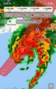
Posted on 9/11/24 at 4:04 am to rds dc
just woke up and looked at the satellite

Posted on 9/11/24 at 4:08 am to DVinBR
Looks like it definitely moved east. Strengthened as well

Posted on 9/11/24 at 4:09 am to tigersownall
Being the only one awake during the big 4AM update and not having my OT brethren explain, bitch about, concern troll, and tell stories about their coworker saying Gonzales will get 25 inches of rain:

Posted on 9/11/24 at 4:13 am to Bottom9
Fox 8 is till intent on having NOLA take it up the poop shoot.
Posted on 9/11/24 at 4:13 am to Bottom9
Expected to be a cat 2 by 1 pm. Maybe sooner
Posted on 9/11/24 at 4:15 am to Bottom9
quote:
Being the only one awake during the big 4AM update
I'm up as well. I haven't heard anything about that amount of rain.
Posted on 9/11/24 at 4:17 am to phil good
quote:
I'm up as well. I haven't heard anything about that amount of rain
Some baw on here's coworker was fear mongering him and his other coworkers about that amount of rain passing through. This was like 100 pages back
Posted on 9/11/24 at 4:20 am to TheGhostOfBigLee
Looks like it's moving right along guidance from yesterday evening

Posted on 9/11/24 at 4:22 am to TheGhostOfBigLee
quote:
Looks like it definitely moved east
Maybe slightly. Not much.
Posted on 9/11/24 at 4:22 am to Bottom9
What’s the update? Where is the storm going to hit center? Crappy weather updates online.
Posted on 9/11/24 at 4:23 am to Bottom9
AccuWeather seems to be on the extreme upper end of wind speed forecasts (perhaps because they classify them as Peak numbers?) but the numbers for the Northshore exploded since midnight and have surpassed BR.
Accuweather Forecasted Impacts Baton Rouge
Peak Sustained Winds 56 mph
Peak Wind Gusts 69 mph
Accuweather Forecasted Impacts Mandeville
Peak Sustained Winds 54 mph
Peak Wind Gusts 72 mph
Accuweather Mandeville
By comparison, the latest from Weather Underground has sustained winds speeds maxing out at 33 mph. That is a huge discrepancy.
Weather Underground Mandeville
EDIT
Best app for wind speed I have experience with is Windfinder. It has winds on the lakefront in Mandeville at 35 sustained gusting to 52. Other sites seem to support this. Accuweather is definitely the outlier.
All of the sites have peak winds hitting Mandeville between 10pm and Midnight tonight (or I guess tomorrow Wednesday if you are still up and in the gin)
This post was edited on 9/11/24 at 4:35 am

Posted on 9/11/24 at 4:25 am to Basura Blanco
Guess to start taking it serious in Biloxi?
Posted on 9/11/24 at 4:28 am to rds dc
Frick! The current track takes the center right over my house.
Posted on 9/11/24 at 4:29 am to tiger lady
quote:
Showing my old age here, but I remember sitting on our front porch during the eye of Hurricane Betsy. We had two pine trees in our front yard and they were leaning to one side from the strong winds during the first half of the storm. They were making a creaking noise and it was kind of creepy. I remember thinking they would get blown down completely during the second half of the storm, but they did not. They are huge trees now and you can see the bend in the trunks from Betsy and then how they just continued growing straight up from that point.
There is a very large pine tree on my way to work that has a distinctive bend in it and a lean toward the north. I've been saying that it will fall in the next hurricane.
I've been saying that for at least the last 20 years. LOL

Posted on 9/11/24 at 4:38 am to EST
 [/url][/img]
 quote:
Frick! The current track takes the center right over my house.
Where you at? Was just looking on the weather channel forecast, the future part of it looks like it takes the eye east of the track. The eye is on the outer part of the projected path.
This post was edited on 9/11/24 at 4:53 am

 Page 292 of 492

Popular
Back to top