- My Forums
- Tiger Rant
- LSU Recruiting
- SEC Rant
- Saints Talk
- Pelicans Talk
- More Sports Board
- Fantasy Sports
- Golf Board
- Soccer Board
- O-T Lounge
- Tech Board
- Home/Garden Board
- Outdoor Board
- Health/Fitness Board
- Movie/TV Board
- Book Board
- Music Board
- Political Talk
- Money Talk
- Fark Board
- Gaming Board
- Travel Board
- Food/Drink Board
- Ticket Exchange
- TD Help Board
Customize My Forums- View All Forums
- Show Left Links
- Topic Sort Options
- Trending Topics
- Recent Topics
- Active Topics
Started By
Message
re: Francine - Landfall in Terrebonne Parish as CAT 2 100 mph
Posted on 9/11/24 at 12:49 am to shoelessjoe
Posted on 9/11/24 at 12:49 am to shoelessjoe
How close are we talking?
 0
0

Posted on 9/11/24 at 12:49 am to lsuman25
quote:
DISCUSSION AND OUTLOOK
----------------------
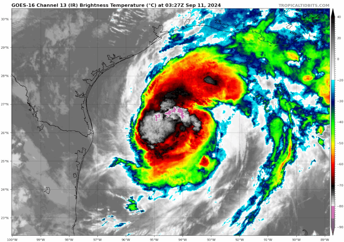
At 100 AM CDT (0600 UTC), the center of Hurricane Francine was
located near latitude 26.6 North, longitude 94.1 West. Francine is
moving toward the northeast near 10 mph (17 km/h). A faster
northeastward motion is expected today, and Francine is anticipated
to make landfall in Louisiana within the warning area this
afternoon or evening. After landfall, the center is expected to
move northward into Mississippi tonight and Thursday.
Data from the Air Force Hurricane Hunters indicate that maximum
sustained winds have increased to near 90 mph (150 km/h) with higher
gusts. Some additional strengthening is expected this morning.
Francine is expected to weaken quickly after it moves inland.
Hurricane-force winds extend outward up to 35 miles (55 km) from
the center and tropical-storm-force winds extend outward up to 115
miles (185 km).
The minimum central pressure based on data from the Air Force
Hurricane Hunters is 977 mb (28.85 inches).

Posted on 9/11/24 at 12:51 am to NorthEndZone
So damn near Cat 2 already?
Posted on 9/11/24 at 12:51 am to BugaNaish
This sucks! I hate hurricanes
Posted on 9/11/24 at 12:51 am to shoelessjoe
quote:
I’ve asked this and haven’t gotten a clear answer. I’m looking on windy.com and noticing that while the storm passes, it’s telling me that the winds will be in the 30/35 mph range. I’m not understanding with the eye passing this close to me, why are those winds that low? Category 1 should be 75mph minimum and I’m not seeing that. Why is that?
Where are you?
Posted on 9/11/24 at 12:52 am to BugaNaish
0z Euro spitting out some pretty sporty wind gusts for BR and SELA


Posted on 9/11/24 at 12:55 am to slackster
quote:
Where are you?
Donaldsonville
Posted on 9/11/24 at 12:58 am to shoelessjoe
I’m not an expert here, but it is safe to say you’ll see over 35 mph winds in Donaldsonville.
Posted on 9/11/24 at 1:00 am to Roux22
Go to nws.gov and type in your ZIP in the upper left corner. It’ll give you wind estimates in a graph.
This post was edited on 9/11/24 at 1:18 am
Posted on 9/11/24 at 1:01 am to shoelessjoe
Windy app might just have some weird data, but there is no guarantee you'll see 75 mph winds just because the storm is rated as such. The winds are in such a small area and you're 50 miles inland.
Hell, Morgan City seeing actual sustained hurricane force winds would be a little surprising.
Try here for NWS forecast for Donaldsonville
Hell, Morgan City seeing actual sustained hurricane force winds would be a little surprising.
Try here for NWS forecast for Donaldsonville
Posted on 9/11/24 at 1:10 am to slackster
Thanks. Appreciate the help. Just concerned is all. Just built a new home and not looking forward to already have problems!!!

Posted on 9/11/24 at 1:24 am to shoelessjoe
I am finally home. Which I am thankful for. I understand actual landfall is later afternoon does anyone estimate when the New Orleans area will start seeing tropical storm force winds?
At one point it was 1pm then I saw 10am earlier. Any update on that?
At one point it was 1pm then I saw 10am earlier. Any update on that?
This post was edited on 9/11/24 at 1:47 am

Posted on 9/11/24 at 1:30 am to Nguyener
Posted on 9/11/24 at 1:38 am to rmnldr
Damn thing looks to be blowing up.
Posted on 9/11/24 at 1:46 am to slackster
quote:
Hell, Morgan City seeing actual sustained hurricane force winds would be a little surprising.
What makes you say that?
Posted on 9/11/24 at 1:47 am to mattchewbocca
quote:
Damn thing looks to be blowing up.
Looks like its moving slightly more east as well.

Posted on 9/11/24 at 1:48 am to Mr Roboto
Showing my old age here, but I remember sitting on our front porch during the eye of Hurricane Betsy. We had two pine trees in our front yard and they were leaning to one side from the strong winds during the first half of the storm. They were making a creaking noise and it was kind of creepy. I remember thinking they would get blown down completely during the second half of the storm, but they did not. They are huge trees now and you can see the bend in the trunks from Betsy and then how they just continued growing straight up from that point.

Posted on 9/11/24 at 1:49 am to MrLSU
quote:
Looks like its moving slightly more east as well.


Posted on 9/11/24 at 1:55 am to MrLSU
Follow it on radar. You can’t follow the center on IR satellite when there no eye. Looks pretty much NE. It’s easier to see on longer radar loops. Use the Houston radar for now.


Posted on 9/11/24 at 2:05 am to The Boat
When is the next recon mission?

 Page 291 of 492

Popular
Back to top