- My Forums
- Tiger Rant
- LSU Recruiting
- SEC Rant
- Saints Talk
- Pelicans Talk
- More Sports Board
- Fantasy Sports
- Golf Board
- Soccer Board
- O-T Lounge
- Tech Board
- Home/Garden Board
- Outdoor Board
- Health/Fitness Board
- Movie/TV Board
- Book Board
- Music Board
- Political Talk
- Money Talk
- Fark Board
- Gaming Board
- Travel Board
- Food/Drink Board
- Ticket Exchange
- TD Help Board
Customize My Forums- View All Forums
- Show Left Links
- Topic Sort Options
- Trending Topics
- Recent Topics
- Active Topics
Started By
Message
re: Francine - Landfall in Terrebonne Parish as CAT 2 100 mph
Posted on 9/10/24 at 12:43 pm to notiger1997
Posted on 9/10/24 at 12:43 pm to notiger1997
quote:
What are the realistic rain amount forecast?
I’m listening to a co-worker losing his mind and telling everyone they are predicting 12-24 inches in the Gonzales area.
I find that hard to believe
QPF is more in the 7-10" range. That is total over the next couple days.
This post was edited on 9/10/24 at 12:43 pm
 0
0


Posted on 9/10/24 at 12:43 pm to notiger1997
quote:
What are the realistic rain amount forecast?


This post was edited on 9/10/24 at 12:45 pm

Posted on 9/10/24 at 12:45 pm to Bayouboogaloocrew
quote:
Hannah Gard on Fox 8 could get it


Posted on 9/10/24 at 12:45 pm to LSUfan4444
My wife just checked. She's seeing 5-8 inches in east Ascension, with numerous 9-11 inches in the Donaldsonville area.
This post was edited on 9/10/24 at 12:56 pm

Posted on 9/10/24 at 12:45 pm to notiger1997
quote:
What are the realistic rain amount forecast?
I’m listening to a co-worker losing his mind and telling everyone they are predicting 12-24 inches in the Gonzales area.
I find that hard to believe
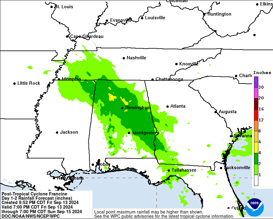
Gonzales is projected to get a total of 6-8" of rain over the next five days.
Posted on 9/10/24 at 12:46 pm to LSUfan4444
We talking power outtages similar to what New Orleans saw with Zeta?
Posted on 9/10/24 at 12:46 pm to Gotabyte
quote:So then who to believe or look at for accurate info on the track. My coworker just said it is moving so much east that MS is going to get hit now. I find that hard to believe but at the same time it does keep tracking east.
They are generally conservative on following model shifts from the original track.
Posted on 9/10/24 at 12:46 pm to redfishfan
12z Euro unchanged on track but slightly stronger at 979mb at Burns Point.

10pm landfall is the latest I’ve seen though. Interesting.
10pm landfall is the latest I’ve seen though. Interesting.
Posted on 9/10/24 at 12:48 pm to Fun Bunch
quote:
By the 10pm run it might be in mobile
If this thing ends up a MS landfall Oysterpoboy won’t ever let us hear the end of it
Posted on 9/10/24 at 12:48 pm to slackster
quote:Lord the 4 year old wont sleep a wink. He cant sleep when it is just a little thunderstorm. That kid is gonna be in bed with me all night.
10pm landfall is the latest I’ve seen though. Interesting.
Posted on 9/10/24 at 12:49 pm to SmogkDeizKnutz
quote:
Seems some models are now steering back west a little and pushing up to Cat 2 again.
Post them or shut the frick up
Posted on 9/10/24 at 12:49 pm to Coatesbathroom
quote:
We talking power outtages similar to what New Orleans saw with Zeta?
I would certainly plan for power outage in metro NOLA at this point.
Posted on 9/10/24 at 12:50 pm to tigafan4life
quote:
My coworker just said it is moving so much east that MS is going to get hit now. I find that hard to believe but at the same time it does keep tracking east.
Depends on what they mean by "hit". I've got screenshots from first thing yesterday morning showing MS and AL both with a decent shot at TS force winds.

Posted on 9/10/24 at 12:50 pm to SmogkDeizKnutz
The center looks better on radar but it's still pretty ragged. The longer it takes to organize and strengthen the better because right now it's in the best environment it's going to have. The environment gets pretty bad in the northern gulf.

Over warm sea surface temps that decrease to the coast

Over a pocket of good ocean heat content, rating the depth and quality of the warm seas

High shear in the northern gulf

Plenty of mid-level dry air (Bingo)

Over warm sea surface temps that decrease to the coast
Over a pocket of good ocean heat content, rating the depth and quality of the warm seas
High shear in the northern gulf
Plenty of mid-level dry air (Bingo)
Posted on 9/10/24 at 12:50 pm to slackster
quote:
10pm landfall is the latest I’ve seen though. Interesting.
frick I hope not...
Posted on 9/10/24 at 12:51 pm to Coatesbathroom
I don't remember Zeta's impact on NOLA to be totally honest but I think the restoration process should be terrible.
Zeta was a bit stronger than what this will be when it makes landfall
Zeta was a bit stronger than what this will be when it makes landfall
This post was edited on 9/10/24 at 12:52 pm
Posted on 9/10/24 at 12:51 pm to tigafan4life
Benadryl. Give the kid Benadryl.

Posted on 9/10/24 at 12:51 pm to The Boat
Nash 'The Boat' Roberts doing frickin' work, baws.
Posted on 9/10/24 at 12:52 pm to The Boat
quote:
Over warm sea surface temps that decrease to the coast
That's the opposite of what I would have intuitively thought. Do you happen to know why the water cools as you get closer to the coast?
Posted on 9/10/24 at 12:52 pm to tigafan4life
quote:
So then who to believe or look at for accurate info on the track. My coworker just said it is moving so much east that MS is going to get hit now. I find that hard to believe but at the same time it does keep tracking east.
Shadyone2 is your coworker?

 Page 227 of 492

Popular
Back to top