- My Forums
- Tiger Rant
- LSU Recruiting
- SEC Rant
- Saints Talk
- Pelicans Talk
- More Sports Board
- Fantasy Sports
- Golf Board
- Soccer Board
- O-T Lounge
- Tech Board
- Home/Garden Board
- Outdoor Board
- Health/Fitness Board
- Movie/TV Board
- Book Board
- Music Board
- Political Talk
- Money Talk
- Fark Board
- Gaming Board
- Travel Board
- Food/Drink Board
- Ticket Exchange
- TD Help Board
Customize My Forums- View All Forums
- Show Left Links
- Topic Sort Options
- Trending Topics
- Recent Topics
- Active Topics
Started By
Message

Deep South Severe Weather Thread (Enhanced)
Posted on 10/24/21 at 11:55 am
Posted on 10/24/21 at 11:55 am


quote:
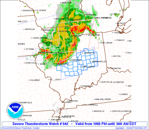
Day 1 Convective Outlook
NWS Storm Prediction Center Norman OK
1121 AM CDT Wed Oct 27 2021
Valid 271630Z - 281200Z
...THERE IS AN ENHANCED RISK OF SEVERE THUNDERSTORMS THIS
AFTERNOON/EVENING ACROSS SOUTHERN LA AND COASTAL MS...
...SUMMARY...
Scattered severe thunderstorms capable of producing damaging winds
and tornadoes, some of which could be strong this afternoon, will
continue spreading eastward across Louisiana to southern Mississippi
through this evening, and across the northeast Gulf coast overnight.
...Northern Gulf coast through tonight...
A midlevel trough over the southern Plains this morning will move
eastward toward the lower MS Valley by early Thursday, while
evolving into a closed low. An associated surface cyclone will
likewise move slowly eastward while occluding across AR tonight, as
a cold front translates eastward from east TX across LA to MS. To
the east, a warm front will move northward across southern LA/MS
today and southern AL/FL Panhandle by tonight. A maritime tropical
air mass is present south of the warm front, with boundary-layer
dewpoints in the low-mid 70s, which is contributing to moderate
buoyancy (MLCAPE of 1000-2000 J/kg this morning across the northwest
Gulf coast. The stronger inland destabilization is expected today
across southern LA as the tropical air mass spreads inland beneath
the east fringe of the steeper midlevel lapse rate plume through the
afternoon as the warm sector spreads northward across southern
LA/MS.
Wind profiles are favorable for tornadic supercells along the north
edge of the warm sector, with effective bulk shear of 40-50 kt and
effective SRH of 200-300 m2/s2, per recent soundings/VWPs and
short-term model forecasts. The potential for occasional discrete
supercells in the warm sector will spread eastward across southern
LA, with an attendant threat for a couple of strong tornadoes near
the warm front. Within the pre-frontal squall line, damaging winds
can be expected with bowing segments, and a tornado threat will also
persist with embedded mesovortices. A similar regime will spread
eastward to southern MS/AL and the FL Panhandle this evening into
tonight, though with slightly weaker buoyancy after the diurnal
heating cycle.
This post was edited on 10/27/21 at 2:48 pm
 20
20


Posted on 10/24/21 at 11:59 am to DVinBR
TL;DR
That’s what’s going to bring the next cool front
That’s what’s going to bring the next cool front
Posted on 10/24/21 at 11:59 am to DVinBR
15% watch out
Posted on 10/24/21 at 12:09 pm to DVinBR
quote:
Developing Deep South Severe Weather Risk Thread (Wednesday)
Not cool.
quote:
by DVinBR
Wait, you're not one of the OT Weather guys.
False alarm.
Posted on 10/24/21 at 12:11 pm to DVinBR
All I need to know is this the front that pushes swamp arse humidity out for good

Posted on 10/24/21 at 12:11 pm to DVinBR
Holy wall of text Batman
Posted on 10/24/21 at 12:13 pm to Icansee4miles
Yada yada punta Cana yada yada titty milk
Posted on 10/24/21 at 12:22 pm to DVinBR
This looks pretty potent, with energy from a huge pacific storm system finally ejecting out of the Rockies by Tuesday. Looks like the trough is going to want to take on a negative tilt, as it digs under a blocking ridge situated roughly over Labrador before cutting up and doing an early season Nor'Easter.
Im watching model trends because this set up looks rife with potential.
Im watching model trends because this set up looks rife with potential.
This post was edited on 10/24/21 at 12:23 pm
Posted on 10/24/21 at 12:28 pm to Duke
We've had a lot of lead time on this one. This was showing up on SPC Day 6. This week is going to be active for alot of folks.
Posted on 10/24/21 at 12:29 pm to Duke
quote:
Looks like the trough is going to want to take on a negative tilt
GFS parced that out early, too. It looks like long range models may do pretty good with this one.
Posted on 10/24/21 at 1:55 pm to LegendInMyMind
We are about to get a good shower in BR. First in a long time. It’s insane the first time that I had to use my sprinkler this year was two weeks ago. We were stuck in a bad wet period before that. It may start up again this winter.
Back to threat for this week…
Back to threat for this week…
Posted on 10/24/21 at 2:04 pm to Duke
quote:
Duke
quote:
Rife with potential
Well there it is damnit

Posted on 10/24/21 at 2:13 pm to DVinBR
I’ve read IT three times, but I’m not reading all that.

Posted on 10/24/21 at 2:30 pm to DVinBR
quote:
rain could be the main impact in some areas. Our big question mark is actually Rick. If the remnants of Rick rolls throug
Posted on 10/24/21 at 2:37 pm to DVinBR
Central MS in "slight" risk.

This post was edited on 10/24/21 at 2:37 pm

Posted on 10/24/21 at 3:09 pm to DVinBR
Is it time to lay in snacks and make groceries?
Posted on 10/24/21 at 3:34 pm to OSoBad
quote:
Central MS in "slight" risk.
I don't know why, but when NWS offices and local outlets do this it kind of irks me. The SPC doesn't put out categorical outlooks beyond day three. That's a day four outlook with the same graphics that the SPC uses for their outlooks. All we have at this point is a probabilistic outlook which is this:
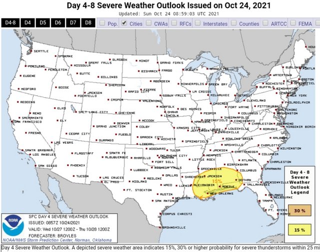
Notice, there's no "Slight, Enhanced, Moderate" etc.
If you're using the SPC outlook, which NWS offices do by design, use them as they are intended. There's a reason they don't release categorical outlooks beyond day three.
Posted on 10/24/21 at 3:35 pm to Johnny3tears
quote:
15% watch out
Facetious?
Because 15 % 3 days out is actually pretty high.

Posted on 10/24/21 at 3:47 pm to DVinBR
I’m placing my money on either Hattiesburg, Tupelo, Tuscaloosa, or Birmingham getting hammered.

Posted on 10/24/21 at 3:49 pm to TDsngumbo
LC is NOT in the cone.
I’m good.
I’m good.

 Page 1 of 23

Popular
Back to top