- My Forums
- Tiger Rant
- LSU Recruiting
- SEC Rant
- Saints Talk
- Pelicans Talk
- More Sports Board
- Fantasy Sports
- Golf Board
- Soccer Board
- O-T Lounge
- Tech Board
- Home/Garden Board
- Outdoor Board
- Health/Fitness Board
- Movie/TV Board
- Book Board
- Music Board
- Political Talk
- Money Talk
- Fark Board
- Gaming Board
- Travel Board
- Food/Drink Board
- Ticket Exchange
- TD Help Board
Customize My Forums- View All Forums
- Show Left Links
- Topic Sort Options
- Trending Topics
- Recent Topics
- Active Topics
Started By
Message
re: Deep South Severe Weather Thread (Enhanced)
Posted on 10/24/21 at 8:37 pm to LegendInMyMind
Posted on 10/24/21 at 8:37 pm to LegendInMyMind
Nope. Dont like that.
 2
2

Posted on 10/24/21 at 8:38 pm to Roll Tide Ravens
quote:
Both of those are being called large and extremely dangerous tornadoes.
Both are probably violent tornadoes hitting at the worst possible time.

Posted on 10/24/21 at 8:38 pm to Duke
Is this the front that’s going to btfo summer for good?

Posted on 10/24/21 at 8:39 pm to LegendInMyMind
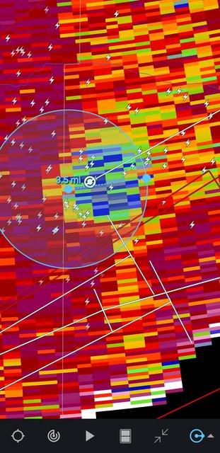
Two large and well defined TDS’s.

Posted on 10/24/21 at 8:40 pm to Roll Tide Ravens
The lead storm of these two has a well-defined BWER on it. Likely rain-wrapped.
This post was edited on 10/24/21 at 8:41 pm
Posted on 10/24/21 at 8:42 pm to When in Rome
This should once again flip the pattern. Lots of troughing in the mid range down in the SE. Im surprised just how strong the rebound in temps was after the last front honestly but the pattern is going to be to push in wind from the NW for days once the storms pass.

Posted on 10/24/21 at 8:43 pm to When in Rome
quote:
Is this the front that’s going to btfo summer for good?
I’ve had enough class disruptions, funny man
Posted on 10/24/21 at 8:47 pm to LegendInMyMind
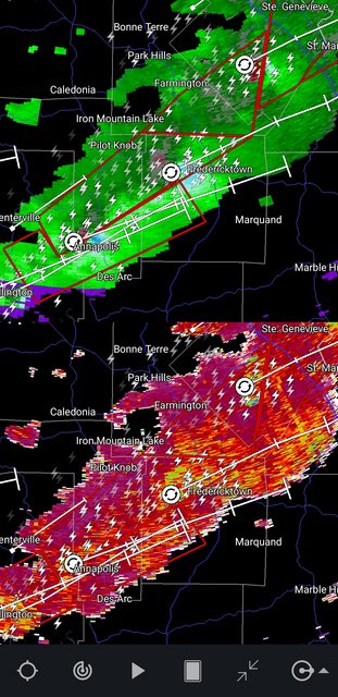
The third rotation in that chain of tornadic cells is ramping up.
This post was edited on 10/24/21 at 8:48 pm
Posted on 10/24/21 at 8:52 pm to LegendInMyMind
The radar can’t see far enough but the fourth one looks tornadic too. It’s a string of four cells.
Posted on 10/24/21 at 8:56 pm to The Boat
Yep. I've been watching the cells popping up on the tail end of the line, too. Hopefully, they don't have room to breathe with the line East of Springfield trying to cut them off.
Posted on 10/24/21 at 8:57 pm to The Boat
Definitely on the ground on the North side of Fredericktown.
This post was edited on 10/24/21 at 8:58 pm
Posted on 10/24/21 at 8:57 pm to The Boat


Posted on 10/24/21 at 8:58 pm to DVinBR
I’m watching two local channels tracking three large, destructive tornadoes in SE Missouri.
Posted on 10/24/21 at 8:59 pm to Pisco
quote:
I’m watching two local channels tracking three large, destructive tornadoes in SE Missouri.
Got a link, or just a channel name?
Posted on 10/24/21 at 9:01 pm to The Boat
quote:
The radar can’t see far enough but the fourth one looks tornadic too.
I think youre right
Posted on 10/24/21 at 9:01 pm to LegendInMyMind

Posted on 10/24/21 at 9:03 pm to Roll Tide Ravens
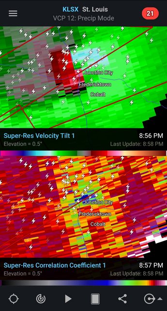
I bet this second one in the chain is also totally rainwrapped.

 Page 3 of 23

Popular
Back to top