- My Forums
- Tiger Rant
- LSU Recruiting
- SEC Rant
- Saints Talk
- Pelicans Talk
- More Sports Board
- Fantasy Sports
- Golf Board
- Soccer Board
- O-T Lounge
- Tech Board
- Home/Garden Board
- Outdoor Board
- Health/Fitness Board
- Movie/TV Board
- Book Board
- Music Board
- Political Talk
- Money Talk
- Fark Board
- Gaming Board
- Travel Board
- Food/Drink Board
- Ticket Exchange
- TD Help Board
Customize My Forums- View All Forums
- Show Left Links
- Topic Sort Options
- Trending Topics
- Recent Topics
- Active Topics
Started By
Message
re: Storm Update:- Ida Moves Away - The Cleanup Begins...
Posted on 8/28/21 at 10:56 am to Cosmo
Posted on 8/28/21 at 10:56 am to Cosmo
quote:
Minimal. Big shifts are done
Yeah. We are at the stage of how strong will it get. It seems to be underperforming what they expected, so far.
This post was edited on 8/28/21 at 10:57 am
 2
2

Posted on 8/28/21 at 10:56 am to STEVED00
#400
Posted on 8/28/21 at 10:56 am to tiger91
4 hunnit
Posted on 8/28/21 at 10:57 am to tiger91
This might be the longest thread in TD history
Posted on 8/28/21 at 10:57 am to DrSteveBrule
Hesding out to Houston early in morning Around 4-5 am. Hopefully most of the crowd will be out and traffic won’t be as bad

Posted on 8/28/21 at 10:57 am to Jake88
quote:
Please define big shifts. Is 30 miles a big shift?
Yes
Posted on 8/28/21 at 10:57 am to ztro4
quote:I'm starting to think "Bingo!" should be a bingo spot with the number of times it has been called in this thread.
Bingo!
Posted on 8/28/21 at 10:58 am to tiger91
Posted on 8/28/21 at 10:59 am to Paul Allen
quote:
does that run show closer to New Orleans than previous ones?
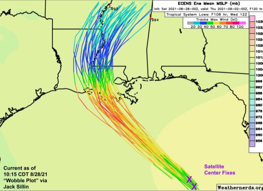
@JackSillin
quote:
During Laura last year, I cobbled together a little visual to monitor trends in the storm's track and distinguish steady trends from short-term wobbles.
Well the #wobbleplot is back for #Ida. Satellite fixes suggest the storm remains towards the eastern edge of track guidance. LINK
Posted on 8/28/21 at 11:00 am to Aech2019
quote:
Question, girlfriend is contemplating whether she should come home to Lafayette or stay in Baton Rouge. What do y’all think?
Lafayette
Posted on 8/28/21 at 11:00 am to STEVED00
quote:agreed- Rapid Intensification does not look to have started yet, or even if it has it’s been delayed for whatever reason. It is organizing a d intensifying but slowly
Yeah. We are at the stage of how strong will it get. It seems to be underperforming what they expected, so far.
Posted on 8/28/21 at 11:00 am to JW6
Thinking of doing the same. Is it too late to get out tomorrow early morning to houston?
Posted on 8/28/21 at 11:01 am to JW6
Would we avoid the parking lot shite of the major highways if we took the backroad to Shreveport? Like…go to Natchez,, cross the river, drive up through Winnsboro to Shreveport? A little longer but not crawling, and probably more gas stations
Posted on 8/28/21 at 11:03 am to glorymanutdtiger
Probably not unless traffic is absolutely fricked.

Posted on 8/28/21 at 11:04 am to TigerNation01
quote:
This might be the longest thread in TD history
There was one that shall not be named that will never be beat.
Posted on 8/28/21 at 11:04 am to CCT
In my experience, that’s definitely the road less traveled.
Posted on 8/28/21 at 11:04 am to JW6
quote:
Hesding out to Houston early in morning Around 4-5 am. Hopefully most of the crowd will be out and traffic won’t be as bad
same here. Leaving from Lafayette
Posted on 8/28/21 at 11:05 am to CCT
with google maps loaded on almost every smartphone these days, there really are no back roads anymore
Posted on 8/28/21 at 11:05 am to Tigers2010a
quote:
Meteorologist Nick Mikulas
The 10:00 AM update from NHC is out. It appears Hurricane Ida is about to rapidly intensify as the eye clears out on satellite, and it taps into the very warm water over the Gulf of Mexico. If you are evacuating near the coast, it’s time to kick things into high gear as things will quickly go downhill tomorrow. Here are the latest numbers on Ida.
LOCATION...24.8N 86.1W
ABOUT 350 MI...565 KM SSE OF THE MOUTH OF THE MISSISSIPPI RIVER
ABOUT 435 MI...700 KM SE OF HOUMA LOUISIANA
MAXIMUM SUSTAINED WINDS...85 MPH...140 KM/H
PRESENT MOVEMENT...NW OR 315 DEGREES AT 16 MPH...26 KM/H
MINIMUM CENTRAL PRESSURE...984 MB...29.06 INCHES
Track guidance is pretty stunning in its consistency. The NHC path brings the center from just west of Baton Rouge, then goes right up the Mississippi River. That would put Alexandria and Pineville about 50-55 miles west of the center. I looked back at radar from Hurricane Laura, and Gustav, and in those, the heavy rain extended about 80-100 miles west of the center. So it’s better to be on the west side, but as I said yesterday, the west side is still rough if you’re pretty close to the center. I drove from Alexandria to College Station TX last year right after Laura. Areas like Jasper Texas, which was 50-60 miles west of the center, still took quite a hard hit. That being said, when you went another 30 miles or so, you didn’t see any damage at all. So the western side is bad, it just doesn’t extend as far as the bad stuff on the eastern side, which can go out a couple hundred miles or more. All that said, here’s an updated parish by parish forecast. Spoiler alert, it hasn’t changed.
Rapides… Wind gusts 50-65 mph 2-6 inches of rain with higher totals in the eastern side of the parish. Scattered power outages.
Avoyelles… Wind gusts 60-75 mph, 5-10 inches of rain, with widespread power outages.
Vernon… Wind gusts 30-45 mph, with 0-2 inches of rain. If this thing nudges east at all, parts of Vernon parish could stay dry. Isolated power outages possible in the eastern part of the parish.
Grant… Wind gusts 40-55 mph, with 1-5 inches of rain. Scattered power outages, especially in the eastern part of the parish.
Sabine… Wind gusts 30-40 mph, 0-2 inches of rain, and I think you keep power. Westward shifts could bring more impact, but for now, things are looking pretty good in Sabine Parish.
Natchitoches… Wind gusts of 35-50 mph, 0-2 inches of rain, with isolated power outages possible in the southeastern part of the parish.
Winn… Wind gusts of 35-50 mph, with 1-4 inches of rain. Isolated power outages are possible.
LaSalle… Wind gusts of 45-55 mph, with 3-6 inches of rain. Scattered power outages are possible.
Catahoula… Wind gusts of 50-60 mph, with 5-8 inches of rain possible. Scattered power outages likely.
Concordia… Wind gusts of 50-65 mph, with 5-10 inches of rain possible. Scattered to widespread power outages likely.
Beauregard… Wind gusts of 30-45 mph, with 0-2 inches of rain possible. Isolated power outages possible in the eastern part of the parish.
Allen… Wind gusts of 45-55 mph, with 2-4 inches of rain likely. Isolated to scattered power outages are possible, with the eastern part of the parish seeing a better chance of losing power.
Evangeline… Wind gusts of 55-65 mph with 3-6 inches of rain. Scattered power outages likely.
St. Landry… Wind gusts of 60-80 mph, with 5-10 inches of rain. Widespread power outages likely, with the worst of that happening in the eastern part of the parish.
Jackson Parish… Wind gusts 30-45 mph with 1-3 inches of rain. Power outages look pretty unlikely.
Caldwell Parish… Wind gusts 35-50 mph with 2-5 inches of rain. Isolated power outages possible.
That’s pretty incredible to not have to change anything, but until I see something worth changing, I’ll leave it as is. What I will continue to try and communicate is that small shifts in track have huge implications for us. A slight westward nudge brings more bad stuff to a larger part of the area. A slight eastward nudge means more areas are in the clear. The weather will start to go downhill in areas that will be impacted by Sunday evening. Perhaps a bit sooner for St. Landry Parish. So you should have most of tomorrow to prepare in this part of the state, with landfall likely around 5:00-10:00 PM Sunday. It’s still entirely possible that western parts of Sabine, Vernon, and Beauregard parish just end up with a breezy Sunday night and Monday and little to no rain. I expect things to calm down by late Monday morning to early Monday afternoon. I’ll update when I see something worth saying, and will update the parish by parish forecast tonight, even if it’s just to say that it hasn’t changed. Today will tell us a lot about how strong Ida will get, and I worry it will get quite strong. Remember, NHC is forecasting a category 4. So if you know someone in an evacuation zone, do what you can to make them take this seriously.

 Page 400 of 1029

Popular
Back to top