- My Forums
- Tiger Rant
- LSU Recruiting
- SEC Rant
- Saints Talk
- Pelicans Talk
- More Sports Board
- Fantasy Sports
- Golf Board
- Soccer Board
- O-T Lounge
- Tech Board
- Home/Garden Board
- Outdoor Board
- Health/Fitness Board
- Movie/TV Board
- Book Board
- Music Board
- Political Talk
- Money Talk
- Fark Board
- Gaming Board
- Travel Board
- Food/Drink Board
- Ticket Exchange
- TD Help Board
Customize My Forums- View All Forums
- Show Left Links
- Topic Sort Options
- Trending Topics
- Recent Topics
- Active Topics
Started By
Message
re: Storm Update:- Ida Moves Away - The Cleanup Begins...
Posted on 8/28/21 at 10:31 am to tduecen
Posted on 8/28/21 at 10:31 am to tduecen
someone posted and shared this, came on my feed just now. Person seems to be very knowledgeable..this is as of 10:03 am cst
quote:
!!!!!!!!!!HURRICANE IDA UPDATE!!!!!!!!!!!
Everything is going as expected with Hurricane Ida. It has emerged off Cuba overnight and is now reorganizing. While still only a Category 1, the structure and "skeleton" of Ida is very impressive. It is in the stages of taking off and rapidly intensifying into a major hurricane. The rapid intensification stage will likely take place overnight and tomorrow morning. Ida will be passing over one of the highest areas of oceanic heat content (first picture). While sea surface temperatures are important for strengthening storms, the depth of the warm waters matters greatly for sustaining major hurricanes.
As of now, recon continues to find a slowly organizing storm with minimal pressure drops, but this is expected as it gears up for overnight. No changes to track, still forecasting a Category 4 at landfall, tornado threat on the eastern side, fresh water flooding from 10-15" rainfall totals, widespread 6-10' storm surge. While storm surge is notoriously the worst impact of major hurricanes, Ida will produce high rainfall totals. The Weather Prediction Center is highlighting a HIGH risk for flash flooding (second and third picture). All of southeast LA will experience widespread 7-10" of rain, but more than likely over a foot in many areas. Anywhere in the third picture where there is a yellow contour is 10+inches of rain forecasted.
Winds will be the wild card if trying to forecast for your area. Still expecting a track that stays just to the west of the Mississippi River near Port Allen. If this occurs then all of Ascension and EBR will experience inner/outer eyewall. It's very difficult to have sustained 100 mph winds that far inland, but I would definitely expect to see sustained hurricane force with 100+ wind gusts. There will be isolated tornadoes for the beginning of the storm, but the main threat will be once the dry air wraps in on the back side where we get isolated banding features. Basically as the storm is exiting the region. These tornadoes will be short-lived and nearly impossible to see. SPC has a SLIGHT risk tomorrow.
Overall, don't expect much to change before tomorrow. Landfall sometime tomorrow afternoon and the worst of the weather will unfortunately be at night. Prepare for a long night Sunday into Monday. Storm should be done by late Monday.
 2
2

Posted on 8/28/21 at 10:32 am to AnthonyJenningsPrais
quote:
I threw a 20lb bag of ice into the water. That storm can’t handle the ice.
No need to do that
The cool rain from the thunderstorm yesterday has us taken care of
This post was edited on 8/28/21 at 10:45 am

Posted on 8/28/21 at 10:32 am to Large Farva
quote:
Boat do you still have the same feeling about BR that you had last night?
It will probably be the strongest winds Baton Rouge has ever gotten from a hurricane. If you're not worried about trees it will be perfectly safe to stay. The aftermath depends on a lot of things including the strength of the trees and improvements to the electrical grid since Gustav.
Posted on 8/28/21 at 10:33 am to tduecen
quote:
Just drink
That’s the plan that started at 830am today
Posted on 8/28/21 at 10:33 am to Cuz413
The rare triple post. Must be having connectivity problems already.

Posted on 8/28/21 at 10:34 am to Front9Bandit
Just keep drinking

Posted on 8/28/21 at 10:34 am to The Boat
quote:
It will probably be the strongest winds Baton Rouge has ever gotten from a hurricane.
Don’t forget about the possibility of 15” of rain. Certainly seems something to think about in Baton Rouge and Ascension lately.

Posted on 8/28/21 at 10:36 am to Delacroix22
When y’all think it’s gonna be prime time on bayou time? I would imagine Martin Folse already has the stick non stop across the screen.
I’m looking forward to the calls and camera footage out of Terrebonne parish.
I’m looking forward to the calls and camera footage out of Terrebonne parish.
Posted on 8/28/21 at 10:36 am to GumboPot
lol, I got flagged for "post quantity" and at some point it went through 2 extra times. I requested they be deleted

Posted on 8/28/21 at 10:36 am to FutureMikeVIII
I think the point being that there is not a 30’ storm surge with this storm like there was for Katrina. Flooding will be from rainfall and could be a few feet in houses. You probably won’t need an axe to escape your attic like you did during Katrina.
Posted on 8/28/21 at 10:37 am to BuddyRoeaux
He had the stick out last night
Posted on 8/28/21 at 10:38 am to Jdiggy
How can you downvote that comment. Lol. What about it is disagreeable?
This post was edited on 8/28/21 at 10:40 am

Posted on 8/28/21 at 10:38 am to Lincoln Dawson
quote:
Person seems to be very knowledgeable
Private meteorologist always are

Posted on 8/28/21 at 10:42 am to Lincoln Dawson
What's the point of posting what they're saying without giving their name? Post their name and let us decide.
Edit: I looked it up, it's by a meteorologist that works for Baron.
Edit: I looked it up, it's by a meteorologist that works for Baron.
This post was edited on 8/28/21 at 10:45 am
Posted on 8/28/21 at 10:44 am to DiamondDog
quote:
Fun fact. Because NOLA did not issue a mandatory evacuation your renters/home insurance will not have to initially pay housing expenses for those evacuating (loss of use).
I was talking about this last night. It's one reason why Calcasieu/LC did a voluntary evac. It was a decision based on resource allocation and not danger. Trying to explain this to people on FB was impossible.
Not declaring mandatory evac may screw some people over.

Posted on 8/28/21 at 10:44 am to GEAUXmedic
New GFS slightly east and slightly weaker

Posted on 8/28/21 at 10:45 am to Cuz413
It happens if you try to post too fast after posting
Posted on 8/28/21 at 10:45 am to rds dc
FYI
I-10 East bound at Biloxi is already a parking lot. If you are heading East, don’t delay.

Posted on 8/28/21 at 10:46 am to The Boat
My semi-daily reminder about the inland flooding threat.

USGS river gauge forecasts with updated projected rainfall. These don't look too terrible, but there may be more of a flash flood problem on the smaller channels and ditches, especially if clogged with debris:
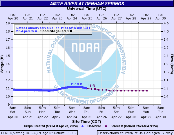
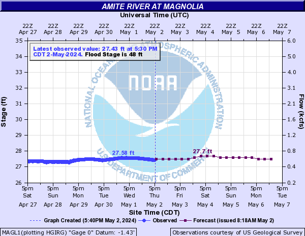
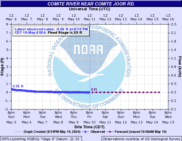
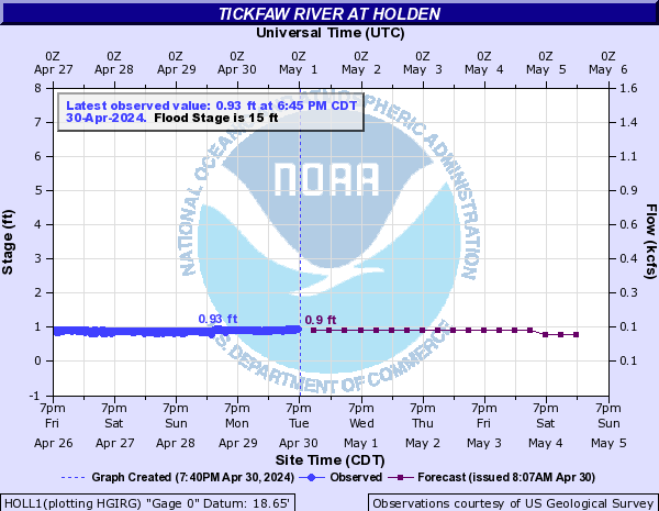


USGS river gauge forecasts with updated projected rainfall. These don't look too terrible, but there may be more of a flash flood problem on the smaller channels and ditches, especially if clogged with debris:
This post was edited on 8/28/21 at 10:48 am
Posted on 8/28/21 at 10:46 am to Cosmo


 Page 398 of 1029

Popular
Back to top