- My Forums
- Tiger Rant
- LSU Recruiting
- SEC Rant
- Saints Talk
- Pelicans Talk
- More Sports Board
- Fantasy Sports
- Golf Board
- Soccer Board
- O-T Lounge
- Tech Board
- Home/Garden Board
- Outdoor Board
- Health/Fitness Board
- Movie/TV Board
- Book Board
- Music Board
- Political Talk
- Money Talk
- Fark Board
- Gaming Board
- Travel Board
- Food/Drink Board
- Ticket Exchange
- TD Help Board
Customize My Forums- View All Forums
- Show Left Links
- Topic Sort Options
- Trending Topics
- Recent Topics
- Active Topics
Started By
Message
re: 1,800+ East Baton Rouge Parish homes may need to be raised because of 2016 floods
Posted on 5/10/21 at 10:57 am to tigeraddict
Posted on 5/10/21 at 10:57 am to tigeraddict
quote:
this is why, had the rain centered over the manchac/Bayou Fountain/Ward's Creek tributary area with the numbers the amite/comite basin area did, flooding would have been much worse in the burbank/nicholson area....
Anyone have a map of the event showing rainfall totals?
 1
1

Posted on 5/10/21 at 11:02 am to chryso
quote:
I don't get how a pond is supposed to work unless the pond was kept empty. So, more like a pit.
Some are designed to be kept empty. Others are designed to hold water and keep it out if the main tributaries. A retention pond.

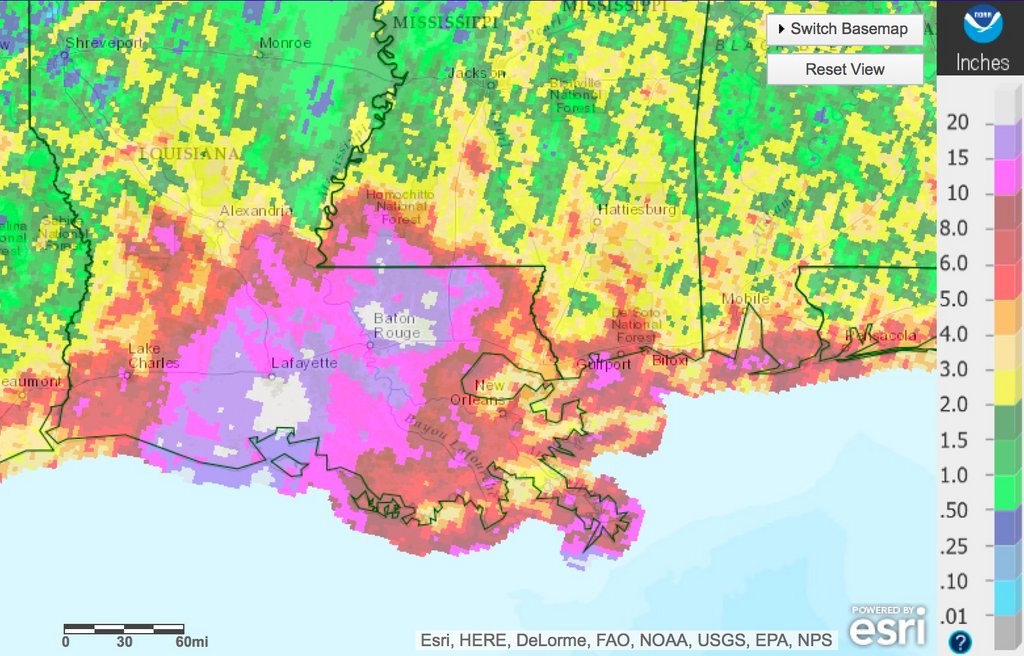
Posted on 5/10/21 at 11:26 am to dewster
Thxs
Below 12 got hammered pretty good but the area just north of 12 got the worst of it.
Below 12 got hammered pretty good but the area just north of 12 got the worst of it.
This post was edited on 5/10/21 at 11:27 am
Posted on 5/10/21 at 11:26 am to dewster
quote:
I also found an estimated inundation map:
looks close in the Tigerbend/Hoo Shoo Too area. I was 2" from water getting in my house and the map has my subdivision as NOT Inundated, but all around inundated
Posted on 5/10/21 at 11:28 am to KLSU
quote:
People and local governments knew of this rule but decided to ignore it, now it's coming back to bite them..
This. I got an elevation certificate to confirm I was above BFE before the parish suspended the rules. Sold that house since so I didn't screw over my buyer but many were screwed over. Actually surprised it’s only 1800 homes in EBRP.
Posted on 5/10/21 at 11:30 am to tigeraddict
quote:
looks close in the Tigerbend/Hoo Shoo Too area. I was 2" from water getting in my house and the map has my subdivision as NOT Inundated, but all around inundated
It's not perfect. They tried to catalogue everything based on the known elevations and which structures they know flooded.
I know there were a lot of neighborhoods where flood waters backed up into city streets, but didn't flood homes or businesses. That's harder to map than a simple "flooded house/dry house".

Posted on 5/10/21 at 11:40 am to member12
Wouldn't this apply to every single business in Denham Springs too?
I'd LOVE to see a revitalized Florida Blvd BUT that will never happen and it's sad. The flood offered a huge opportunity for improvement and they missed a lot of it.
I'd LOVE to see a revitalized Florida Blvd BUT that will never happen and it's sad. The flood offered a huge opportunity for improvement and they missed a lot of it.
Posted on 5/10/21 at 11:56 am to lsusteve1
quote:
Wouldn't this apply to every single business in Denham Springs too?
Not all places that flood have to be raised. And Denham Springs would be handled by Livingston Parish, not EBR.
Posted on 5/10/21 at 11:57 am to lsusteve1
quote:
I'd LOVE to see a revitalized Florida Blvd
There's some movement on this now. Not from flooding and rebuilding, but from Amazon's massive investment into Cortana. Couple of more strip centers are getting renovated and revitalized similar to what was done at Broadmoor Shopping Center.
This post was edited on 5/10/21 at 11:58 am
Posted on 5/10/21 at 1:59 pm to goofball
quote:
Not all places that flood have to be raised. And Denham Springs would be handled by Livingston Parish, not EBR.
Well, I knew this
Just referencing the LP portion of the original post.

Posted on 5/10/21 at 2:31 pm to member12
quote:
Wasn’t it like 22” of rain in 72 hours or something insane like that?
At the airport it was in that 20" range. Some pockets to the NE higher up in the Amite and Comite basins were up around 30", but most of us got way less than that. The problem was how many of us got "only" 10-15 inches of rain. That storm pissed on EVERYONE.
Also, never forget...
"I will stick by what I said earlier. BR won't get near 10-15 inches of rain, unless this system moves in a more northerly direction. I just don't see anything pulling it north." -- Dukke V
This post was edited on 5/10/21 at 2:39 pm

Posted on 5/10/21 at 2:43 pm to TulaneUVA
Those houses in the Seigen curve (across from BREC soccer complex) should have never been built. Ramrodded through by a crooked developer and an otherwise MIA Metro Councilman. That area impounded a TON of water in 2016. Even the modest recent rain events have had the bayou close to overtopping. The retention pond submittals for all these developments are a complete joke.
I hate this town.
I hate this town.
Posted on 5/10/21 at 4:04 pm to Icansee4miles
Wrong topic.
This post was edited on 5/10/21 at 4:05 pm
Posted on 5/10/21 at 4:06 pm to member12
quote:fixed
1,800+ East Baton Rouge Parish homes may need to be razed because of 2016 floods
Posted on 5/10/21 at 6:17 pm to member12
quote:
In 2016 the worst of the rainfall was centered upriver from Baton Rouge. A similar circumstance would have a similar result and spare Burbank again, causing backflow into Spanish Lake again.
I don’t have data to back it up but my gut feel says the exact same rain pattern from 2016 happening again would wreck Burbank neighborhoods. Reason being incremental development
Posted on 5/19/21 at 2:21 pm to Limitlesstigers
The National Flood Insurance Program’s activities are funded largely by the premiums and fees paid by its policyholders, supplemented by a small amount of general funds to help pay for flood risk mapping. Because the National Flood Insurance Program serves the public interest, some believe that more of its funding should be borne by taxpayers.
Posted on 5/19/21 at 2:24 pm to member12
It's amazing when I hear news out of Louisiana I'm very thankful to live in Alabama.
Posted on 5/20/21 at 12:39 am to chryso
Designed correctly a pond is supposed to offset the fill placed in an area. Now the ponds have to be engineered correctly, maintained and kept to their original size and depth.
Not true at all. These ponds are only required to collect the run off from the development in a 10 year flood event. I think they increased it to 25 after 16. It doesn’t address the flooding that is caused North or South of the development by filling in a natural drainage path. Nor affects on existing homes surrounding it. The outrageous amount of building going on needs to be stopped by FEMA and local governments required to develop a recovery plan before another permit is issued. Adding to the problem like we are and it will never get fixed

Posted on 5/20/21 at 7:06 am to WestSideTiger
quote:
Actually surprised it’s only 1800 homes in EBRP.
They probably ran out of paper and just stopped there

 Page 4 of 5

Popular
Back to top