- My Forums
- Tiger Rant
- LSU Recruiting
- SEC Rant
- Saints Talk
- Pelicans Talk
- More Sports Board
- Fantasy Sports
- Golf Board
- Soccer Board
- O-T Lounge
- Tech Board
- Home/Garden Board
- Outdoor Board
- Health/Fitness Board
- Movie/TV Board
- Book Board
- Music Board
- Political Talk
- Money Talk
- Fark Board
- Gaming Board
- Travel Board
- Food/Drink Board
- Ticket Exchange
- TD Help Board
Customize My Forums- View All Forums
- Show Left Links
- Topic Sort Options
- Trending Topics
- Recent Topics
- Active Topics
Started By
Message
re: The Great Flood of 2016: Fill Out Disaster Forms NOW. Link Inside!
Posted on 8/11/16 at 1:51 pm to member12
Posted on 8/11/16 at 1:51 pm to member12
I remember my final semester at LSU, in 1975, it rained constantly in July and the first few days of August.
Was late for quite a few classes over at the Life Sciences bldg. as a result of heavy thunderstorms and lightning. My instructor threatened to dismiss me from the class (could he actually have done that for a few tardies)?
Was late for quite a few classes over at the Life Sciences bldg. as a result of heavy thunderstorms and lightning. My instructor threatened to dismiss me from the class (could he actually have done that for a few tardies)?
 0
0

Posted on 8/11/16 at 1:54 pm to BarnHater

Posted on 8/11/16 at 2:11 pm to jlu03
quote:
but what is your 4k TV saying right now.
There is a lot of red coming, but it looks like it is moving quickly and will pass soon...I don't see anything behind it. Let me know if you need more updates, they show local radar fairly often.

Posted on 8/11/16 at 2:16 pm to Spilled Milk
I will stick by what I said earlier. BR won't get near 10-15 inches of rain, unless this system moves in a more northerly direction. I just don't see anything pulling it north.
Posted on 8/11/16 at 2:19 pm to Spilled Milk
Are you trolling with the weather channel shtick? Or do you not yet know about viewing radar online?

Posted on 8/11/16 at 2:21 pm to MrSmith
quote:
Or do you not yet know about viewing radar online?
couldn't afford a laptop and a 4k tv. priorities baw
Posted on 8/11/16 at 2:22 pm to tke857
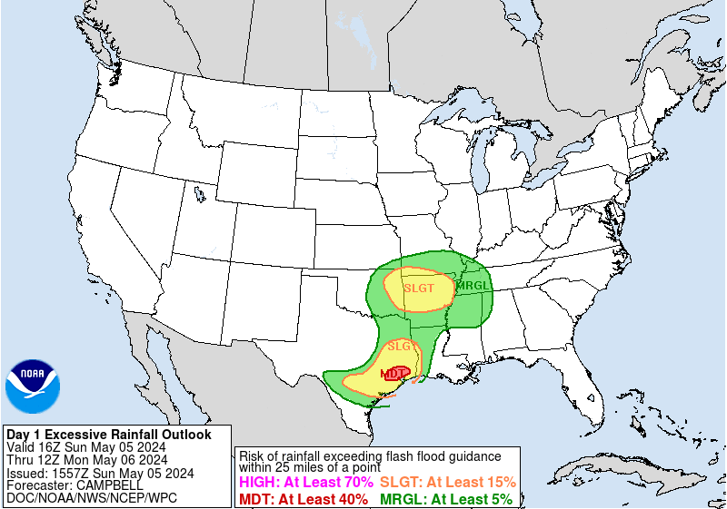
Both the 12z Euro and 12z 4K NAM showing upwards of 25" of rain across portions of S. Louisiana. Obviously, that is probably overdone but there has been pretty consistent agreement b/w the models that someone is going to see some crazy totals.
Latest from NWS WPC:

MESOSCALE PRECIPITATION DISCUSSION 0546
NWS WEATHER PREDICTION CENTER COLLEGE PARK MD
300 PM EDT THU AUG 11 2016
AREAS AFFECTED...SOUTHERN MS...SOUTHEAST AND CENTRAL LA
CONCERNING...HEAVY RAINFALL...FLASH FLOODING LIKELY
VALID 111900Z - 120030Z
SUMMARY...UPGRADE OF EXCESSIVE RAINFALL OUTLOOK TO HIGH RISKED
BASED ON INCREASED DAYTIME HEATING, VERY HIGH MOISTURE AND SLOW
CELL MOTIONS SHOULD POSE FLASH FLOODING CONCERNS ACROSS S MS/SE LA
THROUGH THE EARLY EVENING HOURS.
DISCUSSION...CLEAR SKIES NORTH OF I-10 ACROSS LA INTO S MS HAVE
ALLOWED FOR SFC T TO RISE INTO THE UPPER 80S TO MID
90S...COINCIDENT WITH TDS IN THE MID TO UPPER 70S...REPLENISHING
THE INSTABILITY. GOES-E VISIBLE IMAGERY SHOWS THE APEX OF THE LOW
LEVEL TROF NORTH OF KJAN STARTING TO ALIGN WITH MID TO UPPER LEVEL
SHORTWAVE VORT CENTER...THIS IS CURRENTLY PROVIDING INCREASED
UPPER LEVEL ASCENT AS WELL AS LOWER LEVEL CONVERGENCE TO SUPPORT
INCREASED CONVECTIVE GROWTH OVER THE NEXT FEW HOURS. THE MAIN
HUB/UPPER LEVEL PIVOT REMAINS FURTHER E ALONG THE MS/AL COASTAL
BORDER WITH SLOW DRIFT WHILE 200-250MB OUTFLOW CHANNEL IS PRESENT
WITH THE ENTRANCE REGION ACROSS SE LA. THIS WILL CONTINUE TO
PROVIDE EXCELLENT EVACUATION PARTICULARLY GIVEN THE DIFFLUENCE
WITH NICELY SHAPED ANTICYCLONIC LOOK. CONVECTION NEAR THIS
SOUTHWARD MOVING VORT/CONVERGENCE ZONE WILL BE HIGHLY EFFICIENT
THROUGH A GENERALLY DEEP LAYER...GIVEN SATURATED PROFILES WITH
TPWS OVER 2.5" IN THE AREA OF GREATEST CONCERN (SE LA/NORTH OF
I-10/S MS) RATES IN EXCESS OF 2-2.5" ARE LIKELY AND WITH STRONG
FLUX/MERGERS...WOULD NOT BE SURPRISED OF 1HR TOTALS OVER 3"
POSSIBLE IN ISOLATED SPOTS. OVERALL THE SLOW CELL MOTIONS DUE TO
PROXIMITY TO UPPER LEVEL HUB SHOULD ALLOW FOR SOME VERY HIGH
TOTALS AND PRESENT LIKELY FLASH FLOODING CONDITIONS THOUGH
SUNSET...AS CONVECTIVE VIGOR WILL WANE AS INSTABILITY FROM DAYTIME
HEATING IS EXHAUSTED.
FURTHER WEST ACROSS CENTRAL LA...AN OUTER BAND IS BEGINNING TO
DEVELOP ACROSS THE REGION WHILE THE STATIONARY OLDER CONFLUENCE
BAND FURTHER SOUTH CONTINUES TO REMAIN FED BY LOW LEVEL
CONVERGENCE OUT OF NE TX. EVENTUALLY THE NEWER CONVECTIVE BAND
WILL BE DROP SOUTHWARD AND MELD WITH THE OLDER BAND KEEPING A
THREAT OF INCREASED DURATION/COMPOUNDING TOTALS ACROSS THIS AXIS
THROUGH NIGHT FALL AS WELL.
GALLINA
Latest from NWS WPC:
MESOSCALE PRECIPITATION DISCUSSION 0546
NWS WEATHER PREDICTION CENTER COLLEGE PARK MD
300 PM EDT THU AUG 11 2016
AREAS AFFECTED...SOUTHERN MS...SOUTHEAST AND CENTRAL LA
CONCERNING...HEAVY RAINFALL...FLASH FLOODING LIKELY
VALID 111900Z - 120030Z
SUMMARY...UPGRADE OF EXCESSIVE RAINFALL OUTLOOK TO HIGH RISKED
BASED ON INCREASED DAYTIME HEATING, VERY HIGH MOISTURE AND SLOW
CELL MOTIONS SHOULD POSE FLASH FLOODING CONCERNS ACROSS S MS/SE LA
THROUGH THE EARLY EVENING HOURS.
DISCUSSION...CLEAR SKIES NORTH OF I-10 ACROSS LA INTO S MS HAVE
ALLOWED FOR SFC T TO RISE INTO THE UPPER 80S TO MID
90S...COINCIDENT WITH TDS IN THE MID TO UPPER 70S...REPLENISHING
THE INSTABILITY. GOES-E VISIBLE IMAGERY SHOWS THE APEX OF THE LOW
LEVEL TROF NORTH OF KJAN STARTING TO ALIGN WITH MID TO UPPER LEVEL
SHORTWAVE VORT CENTER...THIS IS CURRENTLY PROVIDING INCREASED
UPPER LEVEL ASCENT AS WELL AS LOWER LEVEL CONVERGENCE TO SUPPORT
INCREASED CONVECTIVE GROWTH OVER THE NEXT FEW HOURS. THE MAIN
HUB/UPPER LEVEL PIVOT REMAINS FURTHER E ALONG THE MS/AL COASTAL
BORDER WITH SLOW DRIFT WHILE 200-250MB OUTFLOW CHANNEL IS PRESENT
WITH THE ENTRANCE REGION ACROSS SE LA. THIS WILL CONTINUE TO
PROVIDE EXCELLENT EVACUATION PARTICULARLY GIVEN THE DIFFLUENCE
WITH NICELY SHAPED ANTICYCLONIC LOOK. CONVECTION NEAR THIS
SOUTHWARD MOVING VORT/CONVERGENCE ZONE WILL BE HIGHLY EFFICIENT
THROUGH A GENERALLY DEEP LAYER...GIVEN SATURATED PROFILES WITH
TPWS OVER 2.5" IN THE AREA OF GREATEST CONCERN (SE LA/NORTH OF
I-10/S MS) RATES IN EXCESS OF 2-2.5" ARE LIKELY AND WITH STRONG
FLUX/MERGERS...WOULD NOT BE SURPRISED OF 1HR TOTALS OVER 3"
POSSIBLE IN ISOLATED SPOTS. OVERALL THE SLOW CELL MOTIONS DUE TO
PROXIMITY TO UPPER LEVEL HUB SHOULD ALLOW FOR SOME VERY HIGH
TOTALS AND PRESENT LIKELY FLASH FLOODING CONDITIONS THOUGH
SUNSET...AS CONVECTIVE VIGOR WILL WANE AS INSTABILITY FROM DAYTIME
HEATING IS EXHAUSTED.
FURTHER WEST ACROSS CENTRAL LA...AN OUTER BAND IS BEGINNING TO
DEVELOP ACROSS THE REGION WHILE THE STATIONARY OLDER CONFLUENCE
BAND FURTHER SOUTH CONTINUES TO REMAIN FED BY LOW LEVEL
CONVERGENCE OUT OF NE TX. EVENTUALLY THE NEWER CONVECTIVE BAND
WILL BE DROP SOUTHWARD AND MELD WITH THE OLDER BAND KEEPING A
THREAT OF INCREASED DURATION/COMPOUNDING TOTALS ACROSS THIS AXIS
THROUGH NIGHT FALL AS WELL.
GALLINA
This post was edited on 8/11/16 at 2:24 pm
Posted on 8/11/16 at 2:25 pm to dukke v
quote:
unless
So you're saying you're sticking to your prediction unless you're wrong. Got it.
Posted on 8/11/16 at 2:31 pm to Python
Lol. I now stand corrected by the latest update. It's moving more north than I thought it would. Baton Rouge is fricked. At least 8-10 inches of rain by Saturday.
Posted on 8/11/16 at 2:33 pm to tke857
How's this going to affect the weather in Punta Canta?

Posted on 8/11/16 at 2:40 pm to dukke v
How many tie downs you have on your home?
Posted on 8/11/16 at 2:41 pm to GeauxElliott
Rapid scan sat imagery is running for the potential flood event. Warning - Heavy Duty Link
Posted on 8/11/16 at 2:43 pm to dukke v
quote:
Lol. I now stand corrected by the latest update.
Too late, the die has been cast and the fate of Baton Rouge was sealed with your prediction in the other thread
Posted on 8/11/16 at 2:44 pm to rds dc

Posted on 8/11/16 at 2:53 pm to dukke v
They're saying 22 inches

Posted on 8/11/16 at 2:55 pm to Hammertime

Posted on 8/11/16 at 2:56 pm to Paul Allen
quote:
They're saying 22 inches
nearly the entire men's 4x200 olympic swimming team.

Posted on 8/11/16 at 2:59 pm to dukke v
quote:
dukke v
quote:
I will stick by what I said earlier. BR won't get near 10-15 inches of rain,
Everyone who wants to live should meet me mid-city to help build the ark.
quote:
At least 8-10 inches of rain by Saturday.
Nevermind.
This post was edited on 8/11/16 at 3:01 pm
Posted on 8/11/16 at 3:26 pm to tke857
Seems like this thread should be stickied and have all of pj's posts deleted from it

Posted on 8/11/16 at 3:40 pm to dukke v
And there it is.

 Page 2 of 472

Popular
Back to top