- My Forums
- Tiger Rant
- LSU Recruiting
- SEC Rant
- Saints Talk
- Pelicans Talk
- More Sports Board
- Fantasy Sports
- Golf Board
- Soccer Board
- O-T Lounge
- Tech Board
- Home/Garden Board
- Outdoor Board
- Health/Fitness Board
- Movie/TV Board
- Book Board
- Music Board
- Political Talk
- Money Talk
- Fark Board
- Gaming Board
- Travel Board
- Food/Drink Board
- Ticket Exchange
- TD Help Board
Customize My Forums- View All Forums
- Show Left Links
- Topic Sort Options
- Trending Topics
- Recent Topics
- Active Topics
Started By
Message
Random Google Maps browsing of the day.
Posted on 5/10/24 at 2:29 pm

Posted on 5/10/24 at 2:29 pm
Friends! Happy Friday!
I will occasionally scroll through google maps satellite to see what I can see. Today I found a random runway in the middle of the Everglades about halfway between Miami and the Gulf of Mexico. Just a runway with no hangars or fuel tanks. Also theres a 747 parked there.


Then the wikipedia dive begins. This was planned to be the largest airport in the world and the hub for commercial supersonic travel with 6 runways. Supersonic travelled was deemed not economically feasable and only 1 runway was built. It is now used for training (and Im sure human trafficking of illegals into this country but wikipedia didnt put that part in.)
LINK
Feel free to add your own google maps random finds.
I will occasionally scroll through google maps satellite to see what I can see. Today I found a random runway in the middle of the Everglades about halfway between Miami and the Gulf of Mexico. Just a runway with no hangars or fuel tanks. Also theres a 747 parked there.
Then the wikipedia dive begins. This was planned to be the largest airport in the world and the hub for commercial supersonic travel with 6 runways. Supersonic travelled was deemed not economically feasable and only 1 runway was built. It is now used for training (and Im sure human trafficking of illegals into this country but wikipedia didnt put that part in.)
LINK
Feel free to add your own google maps random finds.
This post was edited on 5/10/24 at 2:30 pm
 24
24

Posted on 5/10/24 at 2:33 pm to Cosmo
was the first of six planned runways meant to be a hub for super sonic airliners with a high speed rail system connecting to surrounding cities
ETA: I’ll bet the drug lords were salivating for that, maybe even financing it
ETA: I’ll bet the drug lords were salivating for that, maybe even financing it
This post was edited on 5/10/24 at 2:36 pm
Posted on 5/10/24 at 2:35 pm to Cosmo

Posted on 5/10/24 at 2:38 pm to Cosmo
It's crazy that this kind of information can be viewed by just anyone on their laptop. This would have been some top secret stuff at one time. 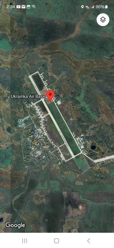

Posted on 5/10/24 at 2:39 pm to Cosmo
A man shitting in the bushes off the Michoud Exit while his wife brings him something to wipe with.


Posted on 5/10/24 at 2:44 pm to Cosmo
I was reading up on this air strip recently. It was mentioned on one of the air crash YouTube channels I watch.

Posted on 5/10/24 at 2:53 pm to Cosmo
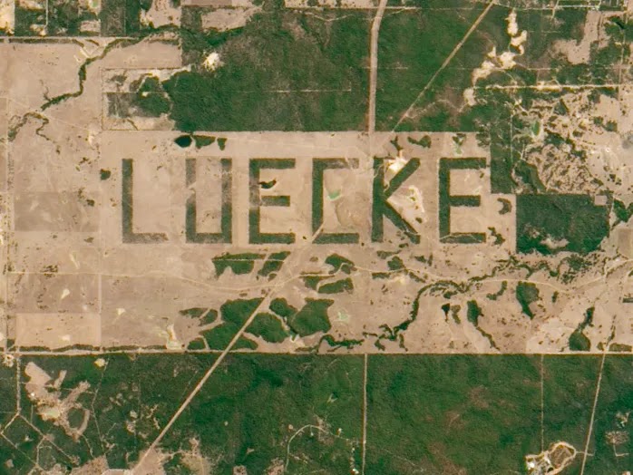
Luecke Farm, Smithville TX

Posted on 5/10/24 at 2:58 pm to Cosmo
My Florida butler left his plane there.
I’ll have my chief pilot mention it to him.
I’ll have my chief pilot mention it to him.
Posted on 5/10/24 at 2:59 pm to Cosmo
quote:
hub for commercial supersonic travel
So you fly in at the speed of sound, then you’re still an hour away from Miami? I can see why it failed.
2hrs to Ft Meyers or West Palm.

Posted on 5/10/24 at 3:02 pm to Cosmo
A lot of people don't think of Florida and oil production, but there is an oil field just north of that runway that's produced more than 22 million barrels of oil.
That's the well road leading North to it in you first picture about a mile or two to the West of the airstrip.
The red tape to drill or even shoot seismic around there has all but made it impossible to further develop. If that was Louisiana, it would be dotted with well pads.
That's the well road leading North to it in you first picture about a mile or two to the West of the airstrip.
The red tape to drill or even shoot seismic around there has all but made it impossible to further develop. If that was Louisiana, it would be dotted with well pads.
Posted on 5/10/24 at 3:03 pm to Cosmo
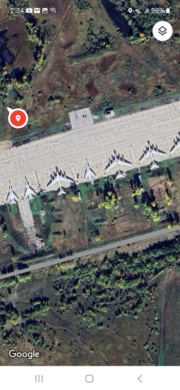
What’s the rectangular shape in the image that appears to be a building?

Posted on 5/10/24 at 3:03 pm to Cosmo
quote:
This was planned to be the largest airport in the world and the hub for commercial supersonic travel with 6 runways. Supersonic travelled was deemed not economically feasable and only 1 runway was built.
It would have obliterated the Everglades. Also, could you imagine having to drive all the way to Big Cypress to catch a plane?

Posted on 5/10/24 at 3:08 pm to Cosmo
Cocaine Cowboys
Posted on 5/10/24 at 3:48 pm to Cosmo
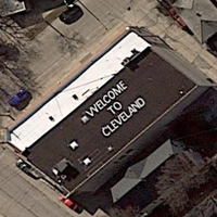
This is what incoming flights see as they approach the airport... in Milwaukee.
Posted on 5/10/24 at 4:10 pm to Cosmo
Nice...
This is a potentially wild subject.
This entire continent is full of already built out road systems, phantom developments and cul-de-sacs, runaways, canals and lakes that shouldn't be there even in developed areas like FL, NJ and NY -- as well as in desolate areas like NV, UT, and even in Louisiana AND Upper Canada.
Are you familiar with Jon Levi?

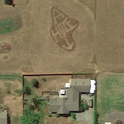
Posted on 5/10/24 at 4:35 pm to Cosmo
There’s a pond on the north side of the landfill in Welsh that used to be home to the Diamond W hunting lodge in the shape of their brand.
It’s now owned by the Columbian “sugarcane farmers” (money launderers) who got a free sugarcane mill from your former state ag commissioner, Bob Odom, whenever there was zero sugarcane being grown within 100 miles.

It’s now owned by the Columbian “sugarcane farmers” (money launderers) who got a free sugarcane mill from your former state ag commissioner, Bob Odom, whenever there was zero sugarcane being grown within 100 miles.
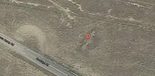
Posted on 5/10/24 at 6:37 pm to Cosmo
In the early days of commercial aviation and air mail service, airplane pilots relied upon light beacons and enormous concrete arrows on the ground to find their way across the country. These navigation aids were built by the Department of Commerce in the 1920s and early 1930s to promote air travel.
Eventually more than 1500 beacons were erected. They were spaced about 10 to 20 miles apart along designated air routes.
The 1st picture is just outside of Albuquerque.

/https://tf-cmsv2-smithsonianmag-media.s3.amazonaws.com/filer/ec/ca/eccab148-56bc-4bc2-b48a-d0d91cc73548/24g_fm2016_silverzone-drone_still_01_live.jpg)
Eventually more than 1500 beacons were erected. They were spaced about 10 to 20 miles apart along designated air routes.
The 1st picture is just outside of Albuquerque.

Posted on 5/10/24 at 7:51 pm to Cosmo
Neighborly revenge...

Posted on 5/10/24 at 7:54 pm to Cosmo
quote:
found a random runway in the middle of the Everglades
That’s a big-arse runway too. 10,500’ long.
That’s the size you see at most Class Bravo airports for the big boys.
Posted on 5/10/24 at 8:59 pm to Cosmo

 Page 1 of 2

Popular
Back to top