- My Forums
- Tiger Rant
- LSU Recruiting
- SEC Rant
- Saints Talk
- Pelicans Talk
- More Sports Board
- Fantasy Sports
- Golf Board
- Soccer Board
- O-T Lounge
- Tech Board
- Home/Garden Board
- Outdoor Board
- Health/Fitness Board
- Movie/TV Board
- Book Board
- Music Board
- Political Talk
- Money Talk
- Fark Board
- Gaming Board
- Travel Board
- Food/Drink Board
- Ticket Exchange
- TD Help Board
Customize My Forums- View All Forums
- Show Left Links
- Topic Sort Options
- Trending Topics
- Recent Topics
- Active Topics
Started By
Message
re: Severe Weather 4/4-4/5 - severe storms ongoing from Arkansas to Michigan.
Posted on 4/4/23 at 9:53 pm to LegendInMyMind

Posted on 4/4/23 at 9:53 pm to LegendInMyMind
That would require the general public having sense…
 1
1

Posted on 4/4/23 at 9:57 pm to Pedro
Here's that storm from a vantage point where you can actually see what happened:
@Weathermansam77
Twitter timelapse
@Weathermansam77
Twitter timelapse
Posted on 4/4/23 at 10:00 pm to The Boat
quote:
Why do people even chase at night
Great question.
Especially in the jungle. What you gonna see even if that lightning flash is timed right?
Posted on 4/4/23 at 10:45 pm to Duke
quote:
NWS Wichita
@NWSWichita
It's official! We've received more rainfall at Eisenhower National Airport tonight (0.15 inches so far) than in the entire month of March (0.12 inches). #kswx
This drought can go frick itself
Posted on 4/5/23 at 5:35 am to Pedro
A few tornado warned storms starting to pop up across NWA now. Guess we may see a few from now til about 8am

Posted on 4/5/23 at 6:00 am to BallHawg10
Decent rotation around Ponca, but nothing confirmed.
Posted on 4/5/23 at 6:02 am to Roll Tide Ravens
NWS also mentioning that the storm that is crossing the MO state line has a strong circulation and could drop a tornado at any time.
Posted on 4/5/23 at 6:10 am to Roll Tide Ravens
Yeah the stuff east of I-49 looks the most well developed but that’s also the least populated area.
The stuff right over 49 is a strong thunderstorm but the rotation is pretty weak/non existent thankfully.
The stuff right over 49 is a strong thunderstorm but the rotation is pretty weak/non existent thankfully.
Posted on 4/5/23 at 6:27 am to BallHawg10
The timing of this one has been all over the place.

Posted on 4/5/23 at 7:09 am to Roll Tide Ravens
Spann
Posted on 4/5/23 at 8:49 am to Roll Tide Ravens
What’s going to hold this system back from being worse for MS today?
Conditions feel primed. Strong south wind, dewpoints near 70 already, sky is clear so doesn’t appear to be capped
Conditions feel primed. Strong south wind, dewpoints near 70 already, sky is clear so doesn’t appear to be capped
Posted on 4/5/23 at 9:02 am to deltaland
quote:
What’s going to hold this system back from being worse for MS today? Conditions feel primed. Strong south wind, dewpoints near 70 already, sky is clear so doesn’t appear to be capped
The system is so far north now that all of the dynamics are pulling away. Ridging over the Gulf and Florida helps to keep pushing the system north.
This post was edited on 4/5/23 at 9:10 am
Posted on 4/5/23 at 9:10 am to Roll Tide Ravens
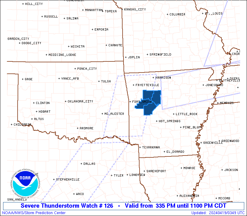
New tornado watch issued about 30 minutes ago:

Posted on 4/5/23 at 9:15 am to Roll Tide Ravens
Just looked and the entire line of thunderstorms from Michigan down to Houston is causing havoc on flights today. Chicago with a ton of delays, St Louis currently, and soon to be Detroit
Posted on 4/5/23 at 9:47 am to CuseTiger
Almost all of Indiana under tornado watch.

Posted on 4/5/23 at 10:21 am to mmcgrath
Waiting for one to form.
Posted on 4/5/23 at 10:36 am to Odysseus32

Posted on 4/5/23 at 10:45 am to mmcgrath
quote:
Is it just a coincidence that the tornado watch over Indiana is shaped like Ohio or are is the NWS just getting creative at this point?
Posted on 4/5/23 at 10:54 am to deltaland
Mississippi is well south of the tornado risk today.
It appears the tornadic focus is on the Upper Midwest; overall even in that area punishing straight-line winds may be the worst threat.
I never heard the term "derecho" before about 10 years ago, when DC was the epicenter of a punishing such storm which struck in the fierce heat of July! Millions of homeowners were without power for weeks, and broiling in the brutal East Coast heat and humidity!
Posted on 4/5/23 at 11:08 am to tarzana
quote:
tarzana
You're the worst.

 Page 8 of 11

Popular
Back to top