- My Forums
- Tiger Rant
- LSU Recruiting
- SEC Rant
- Saints Talk
- Pelicans Talk
- More Sports Board
- Fantasy Sports
- Golf Board
- Soccer Board
- O-T Lounge
- Tech Board
- Home/Garden Board
- Outdoor Board
- Health/Fitness Board
- Movie/TV Board
- Book Board
- Music Board
- Political Talk
- Money Talk
- Fark Board
- Gaming Board
- Travel Board
- Food/Drink Board
- Ticket Exchange
- TD Help Board
Customize My Forums- View All Forums
- Show Left Links
- Topic Sort Options
- Trending Topics
- Recent Topics
- Active Topics
Started By
Message

MERCATOR: Chosen Olde World Map-Maker of the 16th Century (Includes 'The Map')
Posted on 5/1/22 at 1:41 pm
Posted on 5/1/22 at 1:41 pm
For all Olde Map buffs, at this link is a spectacular channel devoted to Gerardus Mercator, credited by historians as the Father of Map-Making or Cartography.
LINK ]Mercator Maps, History, Impact, Projections
*THE MAP CAN BE ENLARGED AND LOCATIONS ZOOMED IN*
The site requires a wee bit of getting used to navigating its unique features, but it is well worth it. It is easy to become immersed in Mercator's great world map (Fwiw, the site has won some design awards.)
The Elephant in the Room: How were such world maps calculations made in the 1500s (credited to Mercator) of land, coasts, interiors, deserts and mountains base logically other than from on Air Flight?
It is conceded that there are "errors" in his map; There places that have changed, disappearing islands and land masses, (marked by named cities, rivers, mountain ranges, fortress markings and other features) and other geographical changes since the 1500s. Among them, the island of Frisland (south of Iceland), Antarctic land mass as well as the detailed land located in the Arctic region -- conspicuous by amount of land and lack of ice in both regions.
Then again, "mistakes" are one thing; But then again -- how are definitive places WITH NAMES "mistakes"?
Conspicuously Missing: All of the Great Lakes in North America do not exist. Instead it is "replaced" by an over-extended St Lawrence River. There is also coincidentally an area on the map named "Chilaga" (at about the same approximate location of where "Chicago" would be.)
There are very plausible theories already available that explain how land AND water levels *could* have been altered during and after 1500s -- as well as plausibly explaining disappearing lands and islands on maps at the time -- but we'll save that discussion for another day.
Mercator's Big Map also made mention then of helpful navigation details, meridian line, latitudes & longitudes, specific side-notes, and curiously -- strange animals referred to as "Monsters" and thought to be "myth" and "legends" of the past; yet, the creatures keep on showing up on other maps throughout early map-makers' history and otherwise (specifically like "Dragons".)
IMPORTANT:
This information is NOT about "Flat" Earth nor will you find any maps of it here. It is about MERCATOR.
For the sake of the board and respect of fellow posters, let's kindly confine the convo and exchanges to the subjects or theories at hand. Thank you for your courtesy.
LINK ]Mercator Maps, History, Impact, Projections
*THE MAP CAN BE ENLARGED AND LOCATIONS ZOOMED IN*
The site requires a wee bit of getting used to navigating its unique features, but it is well worth it. It is easy to become immersed in Mercator's great world map (Fwiw, the site has won some design awards.)
quote:
In the 16th century, Gerardus Mercator, a Flemish cartographer devised a new way of depicting the world on a flat plane. We set off to explore his map in order to illustrate his biggest blunders, unearth curious facts and explain the advantages that make this representation of the globe still relevant today.
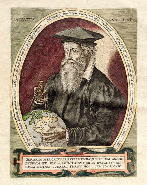
(A portrait of Gerardus Mercator from the book entitled Atlas, or Cosmographical Meditations on the Frame for the World and its Form, 1595)
*THE ABOVE ATLAS CAN BE ENLARGED AND LOCATIONS ZOOMED IN*
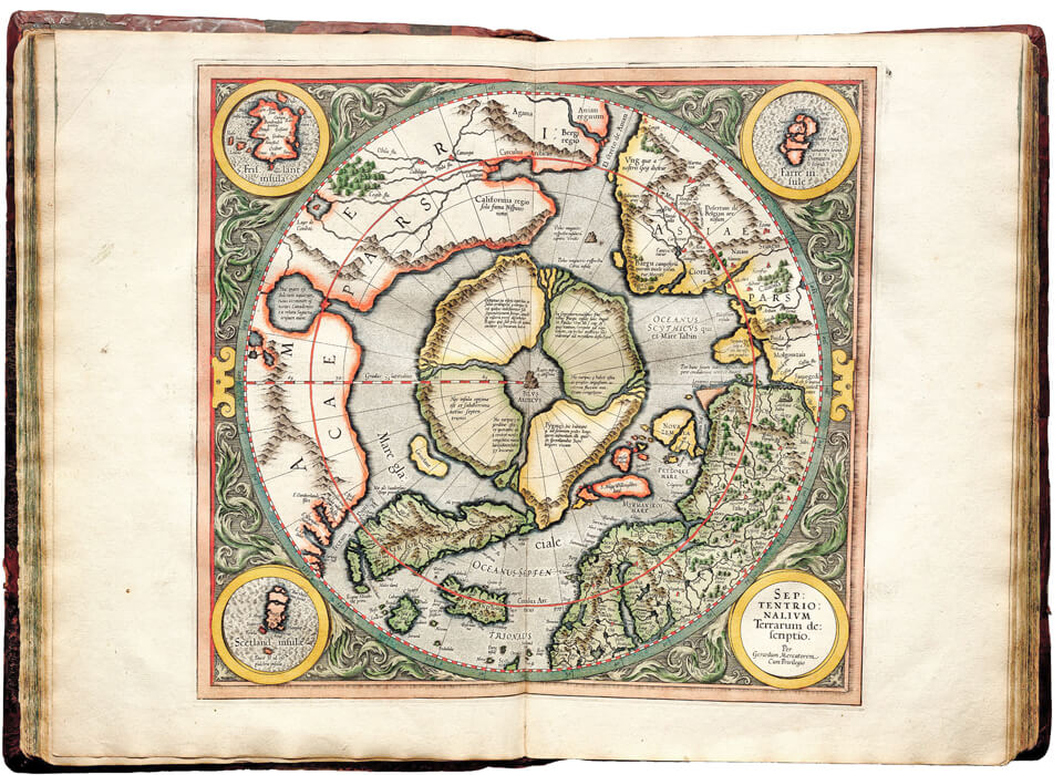
North Pole area in extreme detail -- includes magnetic "North Pole" rock. The Island of 'Frisland' was apparently important enough to this map inset for Mercator to isolate it the upper left (Frisland: located between Iceland and Greenland)
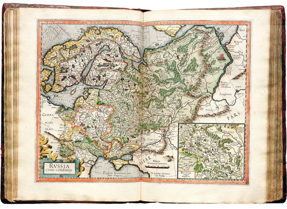
(A very detailed "Rvssia," Eastern Europe, and Scandinavia)
MERCATOR: Map-Maker of The World
Gerardus Mercator has become an iconic name in the science of cartographic projection, but regrettably, all of his other achievements have been mostly neglected. Shortly after the publication of his first map of the world, Mercator, still a young man, set out to make a globe of the Earth, which he completed in 1541.
The globe not only earned Mercator recognition and fame among his fellow mapmakers, it also largely served as the driving force for his introduction to the ruler of Holy Roman Empire Charles V, who would repeatedly commission him to make astronomical instruments and instructions on using them.
In 1512, the family of cobbler Hubert Kremer who had resided in the tiny town of Rupelmonde (then part of the Netherlands) celebrated the birth of his seventh child, a boy named Gerhard. Decades later, he was destined to earn world fame as an outstanding cartographer. In his youth, Gerhard lost his father and means of sustenance, but fortunately his uncle Gisbert stepped in to take his nephew under his wing and became the boy’s guardian, thus letting Gerhard receive a decent education at a gymnasium.
Following the fashion of the era, Gerhard changed his German name Gerhard Kremer (merchant) to its full Latin equivalent of Gerardus Mercator. He moved to Louven, where he graduated from the local university, one of the best in Northern Europe by the standards of those days, and dedicated himself to making globes and geographic charts.
LEGACY
The latter pursuit earned him international distinction. The world-renowned mapmaker, as far as we know, never traveled by sea, but it was Mercator alone that created a groundbreaking map using a principle that would lay the foundation for the entire science of naval navigation. New and More Complete Representation of The Terrestrial Globe Properly Adapted for Use in Navigation was the title of his work in Latin, published in August 1569 that incorporated all the knowledge of geography that was available at that time.
Mercator’s projection is still used for making nautical and aeronautical charts. In a somewhat modified version, it is used for topographic maps of dry land in the United States, Canada, France, Germany and other countries.
It is also the basis for Google and Yandex maps and can be found on most GPS navigation systems known to any driver. A trace of Mercator’s heritage is found even in space research: all images of the Earth taken by the Sentinel-2 and Landsat satellites are shown in his projection.
Mercator’s map turned out to be so handy and convenient that 450 years later we can still see it and enjoy its benefits in our daily routines. And sometimes, when a picture of the world unfolds before our mind’s eye, many of us see it in the image of the Mercator projection.
The Elephant in the Room: How were such world maps calculations made in the 1500s (credited to Mercator) of land, coasts, interiors, deserts and mountains base logically other than from on Air Flight?
It is conceded that there are "errors" in his map; There places that have changed, disappearing islands and land masses, (marked by named cities, rivers, mountain ranges, fortress markings and other features) and other geographical changes since the 1500s. Among them, the island of Frisland (south of Iceland), Antarctic land mass as well as the detailed land located in the Arctic region -- conspicuous by amount of land and lack of ice in both regions.
Then again, "mistakes" are one thing; But then again -- how are definitive places WITH NAMES "mistakes"?
Conspicuously Missing: All of the Great Lakes in North America do not exist. Instead it is "replaced" by an over-extended St Lawrence River. There is also coincidentally an area on the map named "Chilaga" (at about the same approximate location of where "Chicago" would be.)
There are very plausible theories already available that explain how land AND water levels *could* have been altered during and after 1500s -- as well as plausibly explaining disappearing lands and islands on maps at the time -- but we'll save that discussion for another day.
Mercator's Big Map also made mention then of helpful navigation details, meridian line, latitudes & longitudes, specific side-notes, and curiously -- strange animals referred to as "Monsters" and thought to be "myth" and "legends" of the past; yet, the creatures keep on showing up on other maps throughout early map-makers' history and otherwise (specifically like "Dragons".)
IMPORTANT:
This information is NOT about "Flat" Earth nor will you find any maps of it here. It is about MERCATOR.
For the sake of the board and respect of fellow posters, let's kindly confine the convo and exchanges to the subjects or theories at hand. Thank you for your courtesy.
 12
12


Posted on 5/1/22 at 1:44 pm to Liberator
Did he map the world from his perpetual motion, steam punk, dirigible?
Posted on 5/1/22 at 1:56 pm to Liberator
Is this a Tartarian thread?
Posted on 5/1/22 at 2:00 pm to Liberator
...but was he based?

Posted on 5/1/22 at 2:03 pm to Liberator
quote:Good grief. The same way they are today. Vector math from benchmarks, stadia, and a compass.
The Elephant in the Room: How were such world maps calculations made in the 1500s (credited to Mercator) of land, coasts, interiors, deserts and mountains base logically other than from on Air Flight?
I had some property surveyed three weeks ago. Not a single aircraft involved.

Posted on 5/1/22 at 2:03 pm to Liberator
I once programmed point/slope lines to attain x-intercepts into Fortran to figure submarine tracks across polar projected maps in a top secret vault shop. Much more complex than the Mercator maps.
Csb
Csb

Posted on 5/1/22 at 2:11 pm to Liberator
quote:
Conspicuously Missing: All of the Great Lakes in North America do not exist. Instead it is "replaced" by an over-extended St Lawrence River. There is also coincidentally an area on the map named "Chilaga" (at about the same approximate location of where "Chicago" would be.)
There are very plausible theories already available that explain how land AND water levels *could* have been altered during and after 1500s -- as well as plausibly explaining disappearing lands and islands on maps at the time -- but we'll save that discussion for another day.
The shape of North and South Americas are only generally close. He even has what would eventually be the US southwest labeled as "INDIA".
What this seems to indicate is that he was very close with those early explorers and was diligent about detail. This would be why we see much more detail (although much is in error) on the East Coast of what would be the US and almost nothing (which comes across as more guessing than data) for much of the West Coast.

Posted on 5/1/22 at 2:12 pm to Padme
Looks flat to me.
Posted on 5/1/22 at 2:35 pm to Nawlens Gator
The coastlines will contain more detail, not just because they were visited, but because his "customers" are sailors and they have an antipathy of running into "stuff".
Seriously, saw a documentation on James Cook, they showed an overlay of his map of New Zealand on a computer generated one, and him using a plane table, compass and sextant, was remarkably accurate, so much so that it was used as the navigation tool til the 1970s, and his was made in 1769.
As a sidenote, many of the islands, some over a thousand miles apart in the Pacific, were navigated to by locals....with no tools other than the stars.
Great thread thanks guys.
Posted on 5/1/22 at 3:29 pm to trinidadtiger
quote:
As a sidenote, many of the islands, some over a thousand miles apart in the Pacific, were navigated to by locals....with no tools other than the stars.
For the southwest Pacific, they had two additional things.
They knew the difference between volanic clouds and water clouds and if a volcano was in an eruptive stage, that would be noticed and marked on their 'maps' made of wooden twigs and binding material.
And from a distance, taller peaks would kick off clouds. Certain kinds of clouds (like equally spaced, equally sized pouffs) would tell a navigator he was approaching the same place he had seen that pattern previously.
Posted on 5/2/22 at 10:02 am to Liberator
Thank you to the few who posters who contributed to the thread. I'll respond to you another time (Capt Cook's fascinating New Zealand / Antarctica sojourn deserves its own thread)
Peeps...
The smaller color map posted above is NOT THE MAP.
That Mercator Map also included accompanying personal and back-history ACCORDING TO THE HISTORICAL NARRATIVE (which I merely excerpted)
For the record, I believe the Map is extremely accurate as of the year 1569 in certain areas, and more distorted in the "New" World. I do NOT however believe the accompanying "historical narrative". AT ALL. (I know -- big surprise)
Much of what The Narrative tells us about Mercator's 1569 map (along with so MUCH of the pertinent info) is distorted, dismissed, discredited, and ridiculed. And most importantly, omitted AND ignored. It is History Ignored and given a middle-fingered.
NAMED locations of places and landmarks can NOT be fudged or invented; especially NOT by the renown, "respected" Gerardus Mercator. THEY EXISTED. (what of them??)
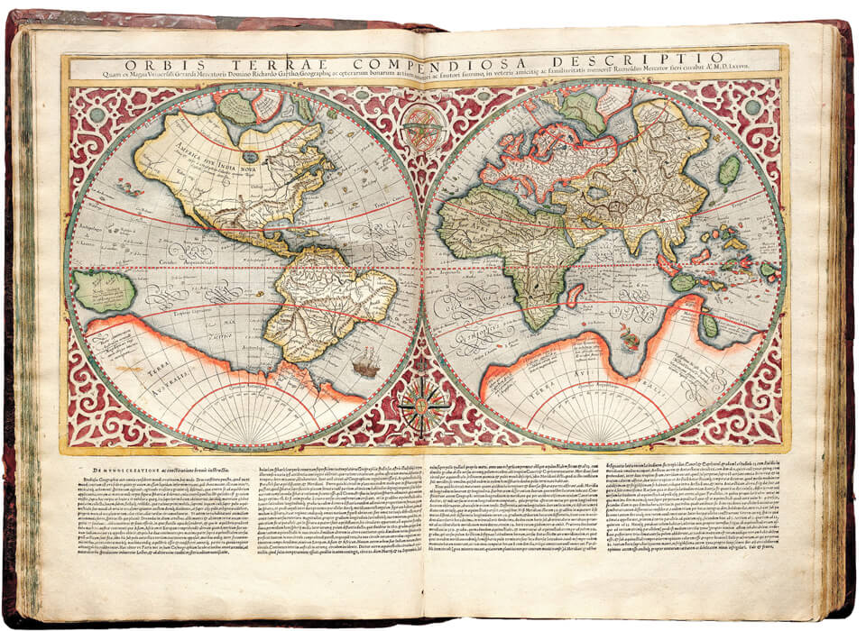
Back to the 1569 Map. (BELOW is a pared down look at THE Mercator's famous detailed Map. You will unfortunately not be able to see details):
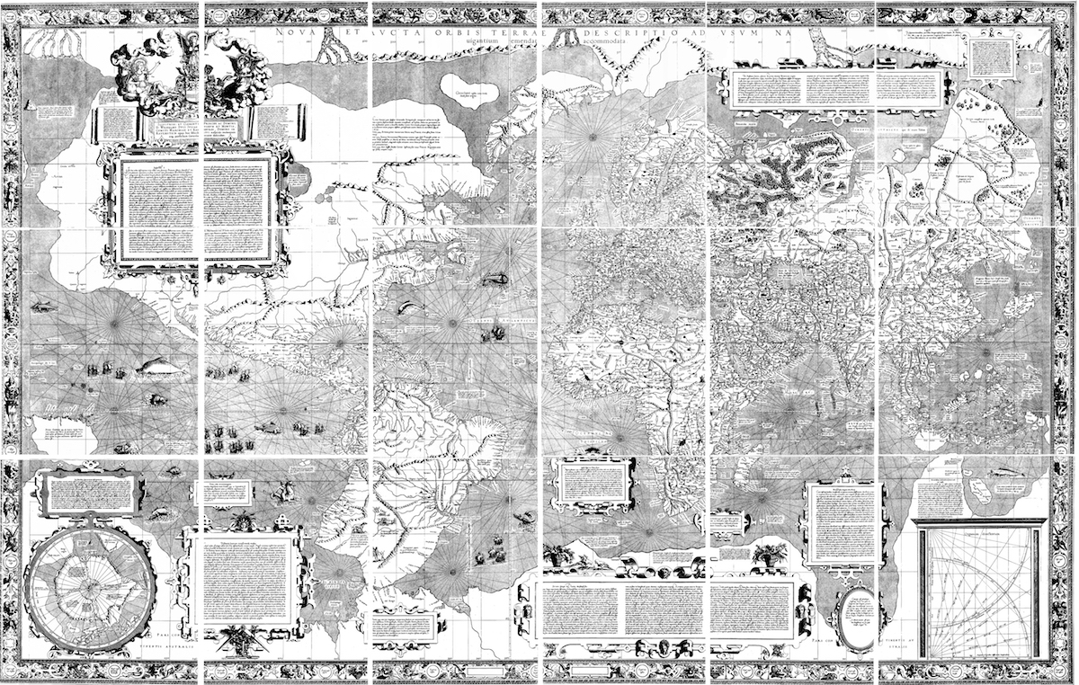
Now if you really want to sink your teeth into and fully examine and scrutinize all of its glorious mind-blowing tiniest details (that can NOT be seen on a monitor screen, nor are discussed at the site/link) then please check out the Link.
1569 Map HUGE
The original actual size of the map by Mercator was 7 FEET by 4 FEET. It's massive. The original is comprised of 18 sperate sections connected into one massive Map. **NOTE: What is posted in the thread is NOT THAT MAP**.
For what it's worth (IMO quite a bit), there is far more info than just the maps (if you prefer a more mainstream take on mapping projections, astronomical calculations, techniques and data, that's also there for you to chew on.
As mentioned, Mercator's Map plots out seldom-discussed SPECIFICS by mainstream History" OR Archaeology -- like already well-established cities & towns, landmarks and places across the earth, like:
- PERU (already extremely well-established and strewn / marked with as many towns as Europe)
- THE SAHARA (marked by established towns AND lakes (!)
- AFRICA (many established equatorial towns and lakes already in place and noted
- The (sunken) Island of Frisland -- many towns BY NAME
- CANADA (above the St Lawrence) is already well established, marked by larger towns/cities. It's olde world architecture validates the area as established far long than the historical narrative
There's so much more; you can literally spend hours poring over the details.
ADDITIONALLY:
Examine SOUTH AMERICA:
- Check out"Patagonia" and it's Giants; There is also two drawings above it that clearly depict a human slaughter AND cannibalism
- Amazonian towns (and rivers and tributaries) are already marked
The "New" World by 1569 is already well established and advanced (the Narrative: "Primitive", hardly known, and NOT established.
As a reminder, to access the original World Map, you must access the site at the link.
Look -- it was absolute impossible to plot out the details of millions of square miles of this world -- and especially no way to "survey" the vast interior continental lands by using instruments, the stars, and mathematical equations and calculations.
Air Flight was obviously already invented and in use. How advanced was at the time? (Do not count on "Historians" or their narrative to let on.)
FINAL NOTES regarding how or why land masses and islands appeared AND disappeared or were altered AFTER 1569:
THEORIES:
There were two recorded events that detailed widespread "Floods," earthquakes and calamities (that possibly caused "Mudfloods")
-- The Flood of 'St Felix' and Rome (around 1530) which is said to have flooded all of Europe
St Felix Flood of November 5th 1530 - Strange Accounts From a 1530 middle-French Book
The Terrible Deluge of Ancient Rome
The Century when everything changed (The 1500s)
-- The simultaneous multiple cataclysmic, climatic anomalies and political events 1811-1817 (see New Madrid earthquakes & mass floods, volcanoes, comets, 'Year Without Summer', famine, War of 1812, Napoleonic Wars, Louisiana Purchase, "Carolina Bay" craters/phenomena, "Island" of California [seen on several maps before 1845), etc.)
LINK ]Trying to connect the dots: The Last Great ReSet 1811-1815; Floods, Volcano's, Comets, Earthquakes, and the End of CA Isle
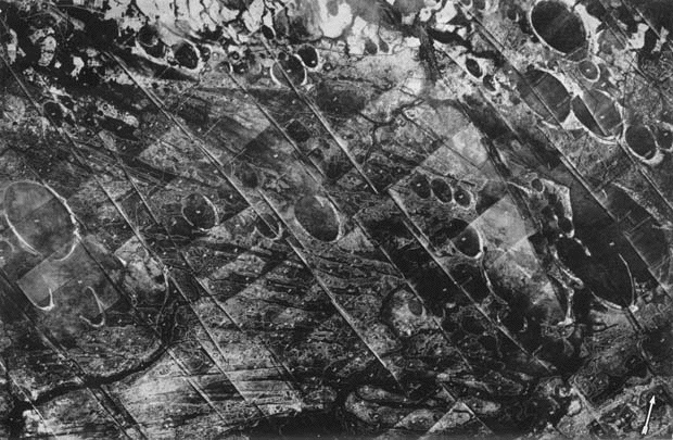
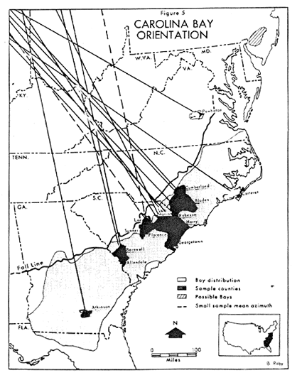
Regarding the Carolina Bay (cratered land phenomena):
“A RE-EVALUATION OF THE EXTRATERRESTRIAL ORIGIN OF THE CAROLINA BAYS”
LINK
The Rabbit Hole... NEVER ends.
Peeps...
The smaller color map posted above is NOT THE MAP.
That Mercator Map also included accompanying personal and back-history ACCORDING TO THE HISTORICAL NARRATIVE (which I merely excerpted)
For the record, I believe the Map is extremely accurate as of the year 1569 in certain areas, and more distorted in the "New" World. I do NOT however believe the accompanying "historical narrative". AT ALL. (I know -- big surprise)
Much of what The Narrative tells us about Mercator's 1569 map (along with so MUCH of the pertinent info) is distorted, dismissed, discredited, and ridiculed. And most importantly, omitted AND ignored. It is History Ignored and given a middle-fingered.
NAMED locations of places and landmarks can NOT be fudged or invented; especially NOT by the renown, "respected" Gerardus Mercator. THEY EXISTED. (what of them??)
Back to the 1569 Map. (BELOW is a pared down look at THE Mercator's famous detailed Map. You will unfortunately not be able to see details):
Now if you really want to sink your teeth into and fully examine and scrutinize all of its glorious mind-blowing tiniest details (that can NOT be seen on a monitor screen, nor are discussed at the site/link) then please check out the Link.
1569 Map HUGE
The original actual size of the map by Mercator was 7 FEET by 4 FEET. It's massive. The original is comprised of 18 sperate sections connected into one massive Map. **NOTE: What is posted in the thread is NOT THAT MAP**.
For what it's worth (IMO quite a bit), there is far more info than just the maps (if you prefer a more mainstream take on mapping projections, astronomical calculations, techniques and data, that's also there for you to chew on.
As mentioned, Mercator's Map plots out seldom-discussed SPECIFICS by mainstream History" OR Archaeology -- like already well-established cities & towns, landmarks and places across the earth, like:
- PERU (already extremely well-established and strewn / marked with as many towns as Europe)
- THE SAHARA (marked by established towns AND lakes (!)
- AFRICA (many established equatorial towns and lakes already in place and noted
- The (sunken) Island of Frisland -- many towns BY NAME
- CANADA (above the St Lawrence) is already well established, marked by larger towns/cities. It's olde world architecture validates the area as established far long than the historical narrative
There's so much more; you can literally spend hours poring over the details.
ADDITIONALLY:
Examine SOUTH AMERICA:
- Check out"Patagonia" and it's Giants; There is also two drawings above it that clearly depict a human slaughter AND cannibalism
- Amazonian towns (and rivers and tributaries) are already marked
The "New" World by 1569 is already well established and advanced (the Narrative: "Primitive", hardly known, and NOT established.
As a reminder, to access the original World Map, you must access the site at the link.
Look -- it was absolute impossible to plot out the details of millions of square miles of this world -- and especially no way to "survey" the vast interior continental lands by using instruments, the stars, and mathematical equations and calculations.
Air Flight was obviously already invented and in use. How advanced was at the time? (Do not count on "Historians" or their narrative to let on.)
FINAL NOTES regarding how or why land masses and islands appeared AND disappeared or were altered AFTER 1569:
THEORIES:
There were two recorded events that detailed widespread "Floods," earthquakes and calamities (that possibly caused "Mudfloods")
-- The Flood of 'St Felix' and Rome (around 1530) which is said to have flooded all of Europe
St Felix Flood of November 5th 1530 - Strange Accounts From a 1530 middle-French Book
The Terrible Deluge of Ancient Rome
The Century when everything changed (The 1500s)
-- The simultaneous multiple cataclysmic, climatic anomalies and political events 1811-1817 (see New Madrid earthquakes & mass floods, volcanoes, comets, 'Year Without Summer', famine, War of 1812, Napoleonic Wars, Louisiana Purchase, "Carolina Bay" craters/phenomena, "Island" of California [seen on several maps before 1845), etc.)
LINK ]Trying to connect the dots: The Last Great ReSet 1811-1815; Floods, Volcano's, Comets, Earthquakes, and the End of CA Isle
Regarding the Carolina Bay (cratered land phenomena):
“A RE-EVALUATION OF THE EXTRATERRESTRIAL ORIGIN OF THE CAROLINA BAYS”
quote:
Our hypothesis takes an entirely different approach, exploring the possibility that the landforms themselves are emplaced terrestrial ejecta, representing the ejecta material of the proposed cometary impacts.
LINK
The Rabbit Hole... NEVER ends.
This post was edited on 5/2/22 at 10:05 am
Posted on 5/2/22 at 10:17 am to Liberator
quote:not if you are a lunatic who thinks that everything was ancient aliens or whatever
The Rabbit Hole... NEVER ends.

Posted on 5/2/22 at 10:19 am to Liberator
I just spent two hours looking at that. Awesome.
- The utm is the first map any kid has seen of the world.
- amazing how they have the same lattitude of the mid Altantic US even with Morocco. Great accuracy and I’m amazed how they did that.
- We studied Carolina bays and the interesting thing was that all or most meteorites have a nw to se orientation.
But the prevailing theory was that it was fluvial deposits.
- the place names they are still here are interesting. Cape Romain SC is still there but the North Carolina capes are named different.
- Also you can try to guess which rivers are current today.
I assume that the Savannah, Cape Fear and Chesapeake Bay are the large inlets of the mid Atlantic. But the Pamlico and Albemarle sounds aren’t there yet.
- look at the Villages that were built by 1538 in your location. Mine are Medano and Ipedra in the Carolinas. Those are interesting and will research them. Even though it’s noted as ipedra in WV.
- Iu Catan is now the Yucatán Peninsula. So the map ACTUALLY taught me about literation of English to Spanish. Vice versus.
This post was edited on 5/2/22 at 10:35 am
Posted on 5/2/22 at 10:19 am to Liberator
I believe that the Carolina Bays were formed as secondary impacts from ejected material of a comet strike on the North American ice sheet near the end of the last ice age. This impact triggered the Younger-Dryas event which eventually resulted in a mass extinction of mega fauna, the end of the ice ages, the permanent raising of sea levels, permanent inundation of most coastal areas, and the destruction of a previously expansive, highly advanced pre-diluvian civilization.

Posted on 5/2/22 at 10:22 am to Liberator
Where is the ice wall?
Posted on 5/2/22 at 10:28 am to Liberator
To those further interested in leaping down the Rabbit Hole of History:
At Stolen History.org are additional intriguing info, theories and forum discussions/opinions shared on respective subjects of 1530 Flood of Rome and the 1811-1812 Destruction and Calamities:
DIFFERENT SOURCE:
1811-12: Destruction Hypothesis
This link is beyond wild but...makes you think.) Theories that question the coincidental War of 1812 (torchings of both DC and Moscow) , Crimean War, Indian War, and the Civil War (as well as abandoned, destroyed cities of the South that resemble European cities that were bombed by fleets of B-24s and hit Wehrmacht Tiger tanks):
1530: The Great Flood of Rome
If you're a big History buff, 'Stolen History.org' is outstanding.
Posted on 5/2/22 at 10:33 am to dstone12
Nice...
Wild ain't it?
Yeah, not all places are figured out on the map. And it helps to know un pocito espanol ;-)
Regarding the Carolina Bay phenomena -- they've calculated the orientation of the "flung" meteors or volcanic boulders /fluvial deposits (??) as being located in Ontario above the Huron/Erie lakes region.
Posted on 5/2/22 at 10:38 am to Liberator
Did he get the St. George lines drawn correctly?
Posted on 5/2/22 at 10:38 am to Liberator
Thanks for sharing, as a Cartographer I love this sort of thing and I'm sure I will waste a lot of time diving deeper into that webpage 
Posted on 5/2/22 at 10:42 am to kingbob
quote:
I believe that the Carolina Bays were formed as secondary impacts from ejected material of a comet strike on the North American ice sheet near the end of the last ice age. This impact triggered the Younger-Dryas event which eventually resulted in a mass extinction of mega fauna, the end of the ice ages, the permanent raising of sea levels, permanent inundation of most coastal areas, and the destruction of a previously expansive, highly advanced pre-diluvian civilization.
It's a good, plausible theory.
All we can do is speculate on the timing of events (and see that they indeed did occur.)
I'm more inclined to believe the Calamity of Calamities was the Noah's Great Flood event. It would have obviously wiped out all of antediluvian world. The volcanic activity must have been beyond epic, creating the mid-Atlantic ridge as well.
Might I add that the Carolina "comet" and material possible massive ejections were the result on an earth already in great flux, heaving volcanic material? (these could have been later stage / Secondary? Tertiary?) Great Flood aftermath.)

 Page 1 of 2

Popular
Back to top