- My Forums
- Tiger Rant
- LSU Recruiting
- SEC Rant
- Saints Talk
- Pelicans Talk
- More Sports Board
- Fantasy Sports
- Golf Board
- Soccer Board
- O-T Lounge
- Tech Board
- Home/Garden Board
- Outdoor Board
- Health/Fitness Board
- Movie/TV Board
- Book Board
- Music Board
- Political Talk
- Money Talk
- Fark Board
- Gaming Board
- Travel Board
- Food/Drink Board
- Ticket Exchange
- TD Help Board
Customize My Forums- View All Forums
- Show Left Links
- Topic Sort Options
- Trending Topics
- Recent Topics
- Active Topics
Started By
Message
re: Wind gusts of up to 100mph possible for Chicago area
Posted on 8/10/20 at 2:34 pm to yaboidarrell
Posted on 8/10/20 at 2:34 pm to yaboidarrell
Maybe it will blow the looters away
 0
0

Posted on 8/10/20 at 2:35 pm to yaboidarrell
That’s it! Cancel Mother Nature. The beech be racist. She ain’t even letting those fine, upstanding individuals help local businesses rid themselves of excess inventory.

Posted on 8/10/20 at 2:40 pm to yaboidarrell

Posted on 8/10/20 at 2:41 pm to tokenBoiler
quote:
Some of y'all shouldn't be surprised when some of us northerners return fire the next time New Orleans gets shite on by mother nature
Between the Bears fans and that idiot Hastert you can frick right off yankee.


Posted on 8/10/20 at 2:47 pm to upgrayedd
quote:
Lori Lightfoot will blame this on the president
Nope, can't do that. This storm is approaching from the left.

Posted on 8/10/20 at 2:52 pm to yaboidarrell
Local news saying that this is very unusual. 110 mph gusts possible.
Tornado popping off around Rockford.
In the hospital with my wife and newborn daughter. Perfectly safe here in Kane County, but it is starting to cloud up.
Tornado popping off around Rockford.
In the hospital with my wife and newborn daughter. Perfectly safe here in Kane County, but it is starting to cloud up.
Posted on 8/10/20 at 3:03 pm to jbgleason
Yeah as if you are a business man sleeping in hotels around the country. Not buying it.
Posted on 8/10/20 at 3:06 pm to tokenBoiler
quote:I hope this turns out to be a non-event for you, but your statement is that of someone who must've been living under a rock from 2005-2009.
Some of y'all shouldn't be surprised when some of us northerners return fire the next time New Orleans gets shite on by mother nature
Posted on 8/10/20 at 3:06 pm to yaboidarrell
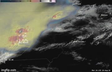
the dark blues in there are 100mph winds 

This post was edited on 8/10/20 at 3:07 pm
Posted on 8/10/20 at 3:07 pm to dewster
quote:
Local news saying that this is very unusual. 110 mph gusts possible.
The strongest derecho I've seen in a few years. A lot of 70+ mph wind reports behind this thing, with one gust over 110 mph in Iowa. It'll come fast, get windy as hell for a few minutes at most and then rain behind it. I'd be inside.

Posted on 8/10/20 at 3:09 pm to jbgleason
quote:
My uncle used to go to Chicago on business once or twice a month. In winter he would have to dodge chunks of ice falling off the buildings.
quote:
A couple of years back I flew up there on an afternoon flight. Immediately went into a business dinner that turned into an all night drink fest. Got up the next morning on two hours sleep and hit all morning business meetings.
Went back to my high rise downtown hotel after lunch and crashed out. Was awakened around 4:00 in the afternoon by an unbelievable amount of noise that lasted a couple of minutes. Got up and got dressed for dinner, walked downstairs to learn that a damn tornado had come straight down the Miracle Mile main drag. I almost completely slept through it. shite was big time torn up. That city gets hit with all kinds of shenanigans.
Anyone else have any boring Chicago stories?
Posted on 8/10/20 at 3:11 pm to yaboidarrell

SEL6
URGENT - IMMEDIATE BROADCAST REQUESTED
Severe Thunderstorm Watch Number 426
NWS Storm Prediction Center Norman OK
1125 AM CDT Mon Aug 10 2020
The NWS Storm Prediction Center has issued a
* Severe Thunderstorm Watch for portions of
Eastern Iowa
Northern Illinois
Far northwest Indiana
Far southern Wisconsin
Lake Michigan
* Effective this Monday morning and evening from 1125 AM until
700 PM CDT.
...THIS IS A PARTICULARLY DANGEROUS SITUATION...
* Primary threats include...
Widespread damaging winds and scattered significant gusts to 100
mph likely
Isolated large hail events to 1.5 inches in diameter possible
A couple tornadoes possible
SUMMARY...A derecho will rapidly progress across eastern Iowa and
northern Illinois this afternoon. Widespread severe wind gusts, some
of which should reach 80-100 mph are anticipated along the track of
the bow. Brief tornadoes are also possible.
The severe thunderstorm watch area is approximately along and 85
statute miles north and south of a line from 20 miles west southwest
of Cedar Rapids IA to 75 miles south southeast of Racine WI. For a
complete depiction of the watch see the associated watch outline
update (WOUS64 KWNS WOU6).
PRECAUTIONARY/PREPAREDNESS ACTIONS...
REMEMBER...A Severe Thunderstorm Watch means conditions are
favorable for severe thunderstorms in and close to the watch area.
Persons in these areas should be on the lookout for threatening
weather conditions and listen for later statements and possible
warnings. Severe thunderstorms can and occasionally do produce
tornadoes.
&&
OTHER WATCH INFORMATION...CONTINUE...WW 425...
AVIATION...A few severe thunderstorms with hail surface and aloft to
1.5 inches. Extreme turbulence and surface wind gusts to 85 knots. A
few cumulonimbi with maximum tops to 600. Mean storm motion vector
27055.
...Grams
Posted on 8/10/20 at 3:12 pm to James11111
Just got tornado warned - Fox Valley. Tri-cities area.
This post was edited on 8/10/20 at 3:15 pm

Posted on 8/10/20 at 3:13 pm to Duke
We had a derecho here in Tennessee a couple months back. That shite was no joke. Our neighborhood got demolished by 80 mph winds.

Posted on 8/10/20 at 3:14 pm to Duke
quote:
The strongest derecho I've seen in a few years.
Didn't we have a real strong one in BR 4-5 years ago? That was some of the worst weather I can recall being in for about 10-15 minutes that wasn't a hurricane.
Posted on 8/10/20 at 3:15 pm to yaboidarrell
If you don't like the weather in (fill in your city/state here), then wait 5 minutes!!
This post was edited on 8/10/20 at 3:17 pm
Posted on 8/10/20 at 3:16 pm to yaboidarrell

Posted on 8/10/20 at 3:18 pm to fallguy_1978
quote:
Didn't we have a real strong one in BR 4-5 years ago? That was some of the worst weather I can recall being in for about 10-15 minutes that wasn't a hurricane.
It didn't meet the rigorous definition but that was a derecho in terms of effects and how it acted.
There are reports with this one today there might be some strong winds trailing. Radar suggests as much. The front end is producing some incredible wind in a few locations. Got 126 mph showing up just 1000 feet off the ground.
ETA: That big wind reading is an apparent embedded tornado.
This post was edited on 8/10/20 at 3:24 pm
Posted on 8/10/20 at 3:28 pm to Duke
Just lost power in the hospital. Took a few min to come back on. Watching the storm on the Ring doorbell camera and through the hospital window. Pretty intense but nothing crazy.
I’ve seen worse storms in this area.
I took about 5 minutes to pass through. Now it’s just rain.
I’ve seen worse storms in this area.
I took about 5 minutes to pass through. Now it’s just rain.
This post was edited on 8/10/20 at 3:31 pm

 Page 2 of 4

Popular
Back to top