- My Forums
- Tiger Rant
- LSU Recruiting
- SEC Rant
- Saints Talk
- Pelicans Talk
- More Sports Board
- Fantasy Sports
- Golf Board
- Soccer Board
- O-T Lounge
- Tech Board
- Home/Garden Board
- Outdoor Board
- Health/Fitness Board
- Movie/TV Board
- Book Board
- Music Board
- Political Talk
- Money Talk
- Fark Board
- Gaming Board
- Travel Board
- Food/Drink Board
- Ticket Exchange
- TD Help Board
Customize My Forums- View All Forums
- Show Left Links
- Topic Sort Options
- Trending Topics
- Recent Topics
- Active Topics
Started By
Message
re: Weather for Monday, May 20. Attention: N TX, Cen. OK, S KS High risk forecast
Posted on 5/20/19 at 9:57 pm to slackster
Posted on 5/20/19 at 9:57 pm to slackster
It'll work for our purposes.
So the sounding from Norman tonight explains a lot, cap showed up stronger than earlier in the day and a little lower.
So the sounding from Norman tonight explains a lot, cap showed up stronger than earlier in the day and a little lower.
 2
2

Posted on 5/20/19 at 10:01 pm to slackster
quote:

URGENT - IMMEDIATE BROADCAST REQUESTED
Tornado Watch Number 202
NWS Storm Prediction Center Norman OK
950 PM CDT Mon May 20 2019
The NWS Storm Prediction Center has issued a
* Tornado Watch for portions of
West and Southwest Texas
* Effective this Monday night and Tuesday morning from 950 PM
until 400 AM CDT.
* Primary threats include...
A few tornadoes possible
Scattered large hail and isolated very large hail events to 2.5
inches in diameter likely
Scattered damaging wind gusts to 70 mph possible
SUMMARY...Isolated supercells will persist this evening across the
Low Rolling Plains, while additional storms will continue to
increase farther to the southwest across southwest Texas. A tornado
or two remain possible, with large hail and locally damaging winds
also likely.
The tornado watch area is approximately along and 70 statute miles
north and south of a line from 35 miles northeast of Abilene TX to
25 miles west southwest of Midland TX. For a complete depiction of
the watch see the associated watch outline update (WOUS64 KWNS
WOU2).
PRECAUTIONARY/PREPAREDNESS ACTIONS...
REMEMBER...A Tornado Watch means conditions are favorable for
tornadoes and severe thunderstorms in and close to the watch
area. Persons in these areas should be on the lookout for
threatening weather conditions and listen for later statements
and possible warnings.
&&
OTHER WATCH INFORMATION...CONTINUE...WW 199...WW 200...WW 201...
AVIATION...Tornadoes and a few severe thunderstorms with hail
surface and aloft to 2.5 inches. Extreme turbulence and surface wind
gusts to 60 knots. A few cumulonimbi with maximum tops to 600. Mean
storm motion vector 24030.
...Guyer
Posted on 5/20/19 at 10:01 pm to Duke
Not sure how long these cells stay in this shape, but the stuff Around Abilene could be trouble for Wichita Falls.
Posted on 5/20/19 at 10:04 pm to rt3
What do any of you see SW of Hamlin, Texas? Looks like a pretty good hook. Decent sized town of over 2,000. Hope they are taking cover and it misses them.

Posted on 5/20/19 at 10:04 pm to Hawgeye
Thanks
Posted on 5/20/19 at 10:07 pm to slackster
Wouldn't be surprised if they kept themselves strong for a while. System is getting a little forcing kick as the system starts to pull off toward the NE tonight.
Posted on 5/20/19 at 10:08 pm to NorthEndZone
quote:
What do any of you see SW of Hamlin, Texas? Looks like a pretty good hook. Decent sized town of over 2,000. Hope they are taking cover and it misses them.
Most of these storms have been broad rotations on the velocity parameters, but the radar signatures have looked much worse. Hopefully it's just a scary rotating wall cloud and nothing else.
Posted on 5/20/19 at 10:11 pm to slackster
Yeah. The one NW of Sweetwater and SW of Roby TX looks good on velocity but like you said it may not be near or on ground.
Posted on 5/20/19 at 10:11 pm to NorthEndZone
I guess I was too optimistic.

Posted on 5/20/19 at 10:11 pm to Duke
quote:
So the sounding from Norman tonight explains a lot, cap showed up stronger
The 00z NAM 12k from last night did a good job of capturing this showing 700mb temps of 10C+ nosing up into OK at 00z tonight. That matches up pretty good with SPC meso from earlier:

What was an otherwise incredible convective environment was held in check by slightly warmer than anticipated air at that level. If those temps are slightly cooler, we are probably talking about long track tornadic supercells that moved through DFW and then northward towards OKC.
Posted on 5/20/19 at 10:14 pm to rds dc
quote:
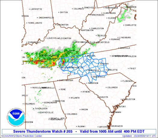
URGENT - IMMEDIATE BROADCAST REQUESTED
Tornado Watch Number 203
NWS Storm Prediction Center Norman OK
1005 PM CDT Mon May 20 2019
The NWS Storm Prediction Center has issued a
* Tornado Watch for portions of
Southern and East-Central Oklahoma
Western North Texas
* Effective this Monday night and Tuesday morning from 1005 PM
until 500 AM CDT.
* Primary threats include...
A few tornadoes and a couple intense tornadoes possible
Scattered damaging wind gusts to 70 mph likely
Scattered large hail and isolated very large hail events to 2
inches in diameter possible
SUMMARY...A mixed mode of storms including a few supercells and
bowing segments will continue to move east-northeastward across the
region into the overnight. A few tornadoes remain a possibility,
with damaging winds and isolated large hail a possibility.
The tornado watch area is approximately along and 60 statute miles
north and south of a line from 50 miles east southeast of Chandler
OK to 50 miles south southwest of Altus OK. For a complete depiction
of the watch see the associated watch outline update (WOUS64 KWNS
WOU3).
PRECAUTIONARY/PREPAREDNESS ACTIONS...
REMEMBER...A Tornado Watch means conditions are favorable for
tornadoes and severe thunderstorms in and close to the watch
area. Persons in these areas should be on the lookout for
threatening weather conditions and listen for later statements
and possible warnings.
&&
OTHER WATCH INFORMATION...CONTINUE...WW 200...WW 201...WW 202...
AVIATION...Tornadoes and a few severe thunderstorms with hail
surface and aloft to 2 inches. Extreme turbulence and surface wind
gusts to 60 knots. A few cumulonimbi with maximum tops to 600. Mean
storm motion vector 22030.
...Guyer
Posted on 5/20/19 at 10:17 pm to Duke
quote:
Traffic jams in rural Oklahoma.
How TF does this happen?
Posted on 5/20/19 at 10:18 pm to deltaland
Hamlin about to get it again.
Posted on 5/20/19 at 10:18 pm to rt3
on and off storms now
Posted on 5/20/19 at 10:22 pm to rds dc
Going to call that a win.

Posted on 5/20/19 at 10:25 pm to Duke
The storms northwest of Abilene are pretty nasty looking.
This post was edited on 5/20/19 at 10:26 pm
Posted on 5/20/19 at 10:28 pm to slackster
Assuming we aren't finished here in the Falls
Posted on 5/20/19 at 10:31 pm to wfallstiger
Assume you're not. Anyone not currently in the main line could see a spin up over night, and possibly a stronger one. Not like a mile wide wedge, but be aware.
Posted on 5/20/19 at 10:35 pm to deltaland
I think it was bc of all the dumbass stormchasers

Posted on 5/20/19 at 10:41 pm to Duke
Welp...just got out of safe room. Looks like Locust Grove has one on the ground to my northeast.
Shits getting hairy
Shits getting hairy

 Page 28 of 31

Popular
Back to top