- My Forums
- Tiger Rant
- LSU Recruiting
- SEC Rant
- Saints Talk
- Pelicans Talk
- More Sports Board
- Fantasy Sports
- Golf Board
- Soccer Board
- O-T Lounge
- Tech Board
- Home/Garden Board
- Outdoor Board
- Health/Fitness Board
- Movie/TV Board
- Book Board
- Music Board
- Political Talk
- Money Talk
- Fark Board
- Gaming Board
- Travel Board
- Food/Drink Board
- Ticket Exchange
- TD Help Board
Customize My Forums- View All Forums
- Show Left Links
- Topic Sort Options
- Trending Topics
- Recent Topics
- Active Topics
Started By
Message
 1
1

Posted on 5/20/19 at 11:25 pm to slackster
Good news is the cell has looked worse and worse since that MSD was issued.
Posted on 5/20/19 at 11:26 pm to WylieTiger
quote:
About a month or 2 ago.
ah yes... just found the TD thread on that particular tornado... definitely helped jog the memory
Posted on 5/20/19 at 11:31 pm to rt3
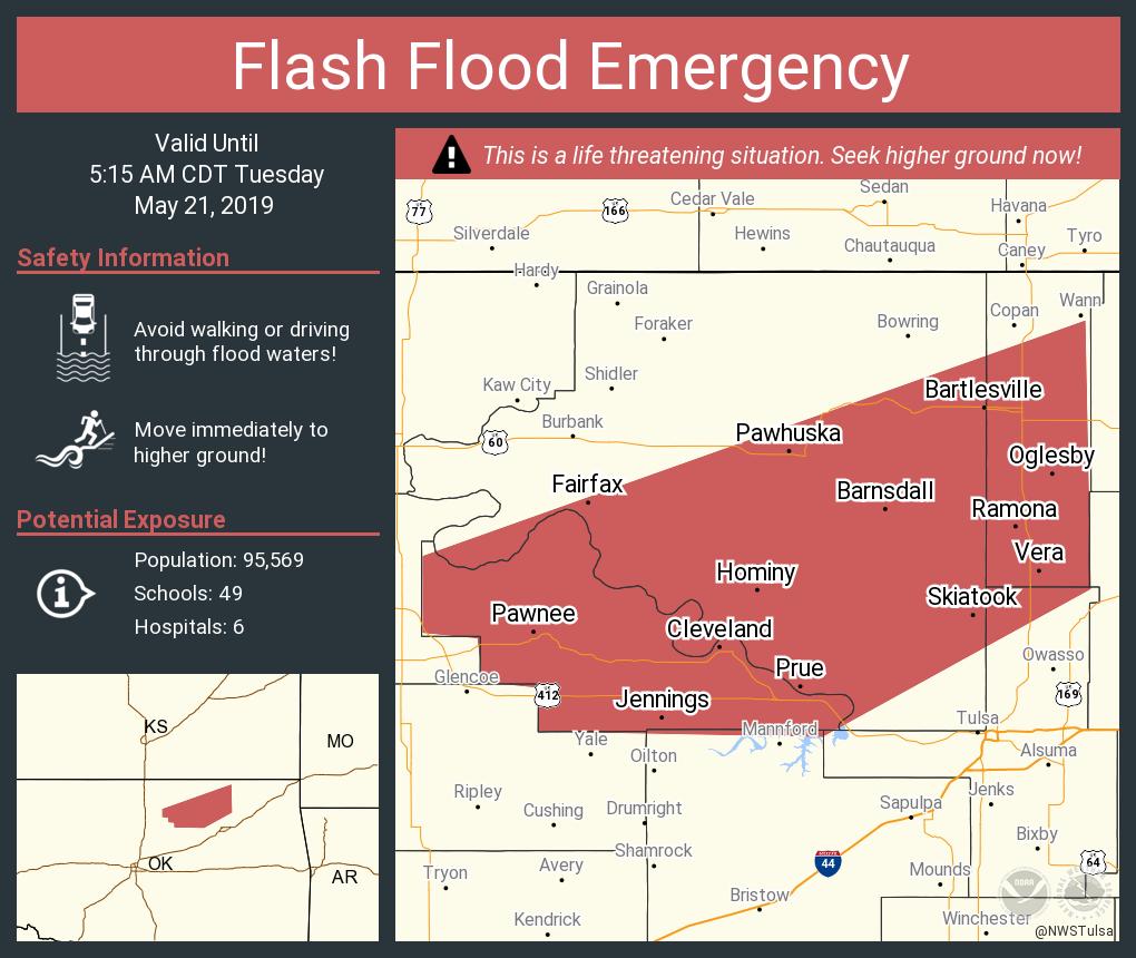
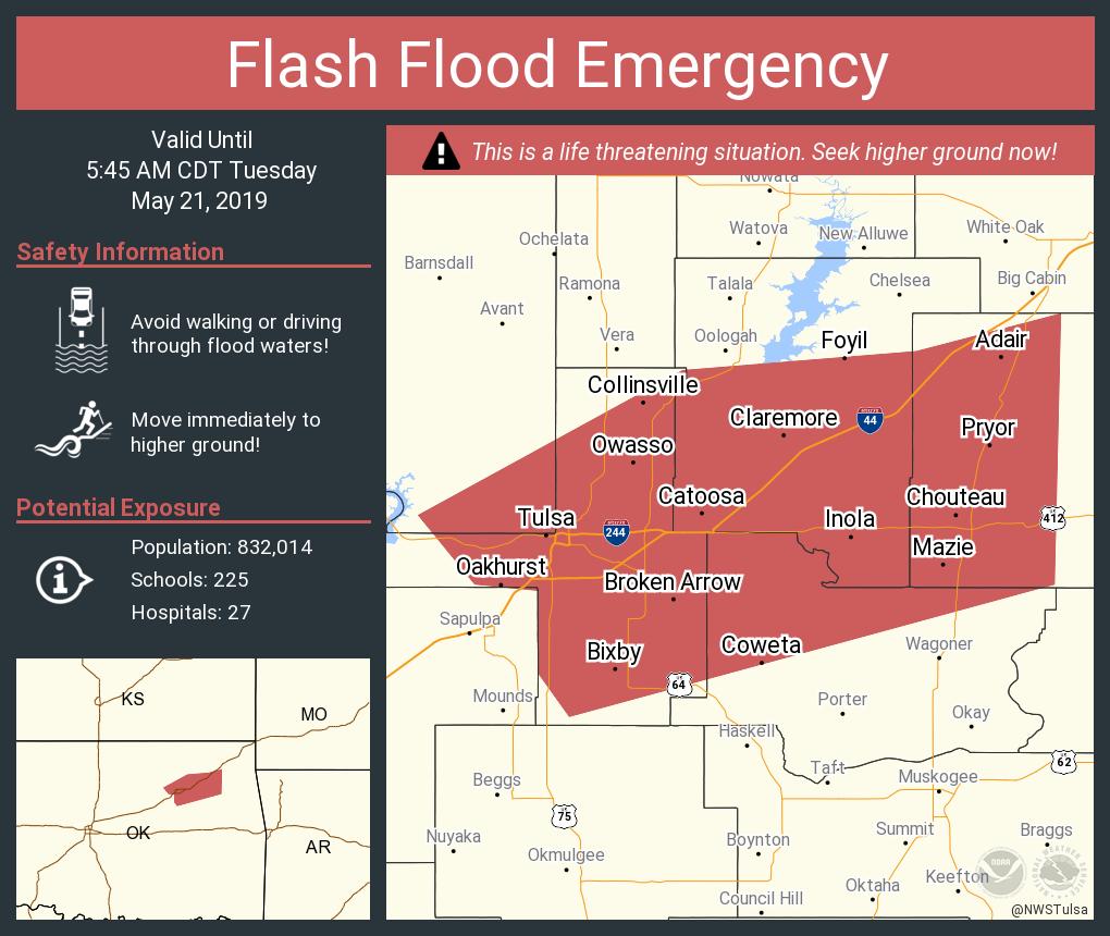
Flash Flood Emergency in or near Tulsa
Posted on 5/20/19 at 11:35 pm to rt3
quote:

Mesoscale Discussion 0716
NWS Storm Prediction Center Norman OK
1131 PM CDT Mon May 20 2019
Areas affected...portions of west-central Texas
Concerning...Tornado Watch 202...
Valid 210431Z - 210530Z
The severe weather threat for Tornado Watch 202 continues.
SUMMARY...The severe threat continues across WW 202.
DISCUSSION...A mix of cellular and linear modes continue to
migrate/propagate northeastward across WW 202 at this time. Storms,
however, are trending toward growing upscale, with outflow
boundaries becoming increasingly separated from heavier thunderstorm
cores except for a bowing segment located near Kent/Scurry Counties.
These storms remain in an unstable, strongly sheared environment and
will progress eastward into very strong low-level flow (60 knots at
850 hPa based on mesoanalyses), with damaging wind gusts, hail, and
isolated tornadoes remaining possible. Additionally development
appears likely to occur on the southern flank of the dominant linear
complex in western portions of the WW near a dryline extending from
MAF southward to about 30 N 6R6, and these storms will also likely
grow upscale into linear segments.
..Cook.. 05/21/2019
Posted on 5/20/19 at 11:37 pm to rt3
re: the Flash Flood Emergency...
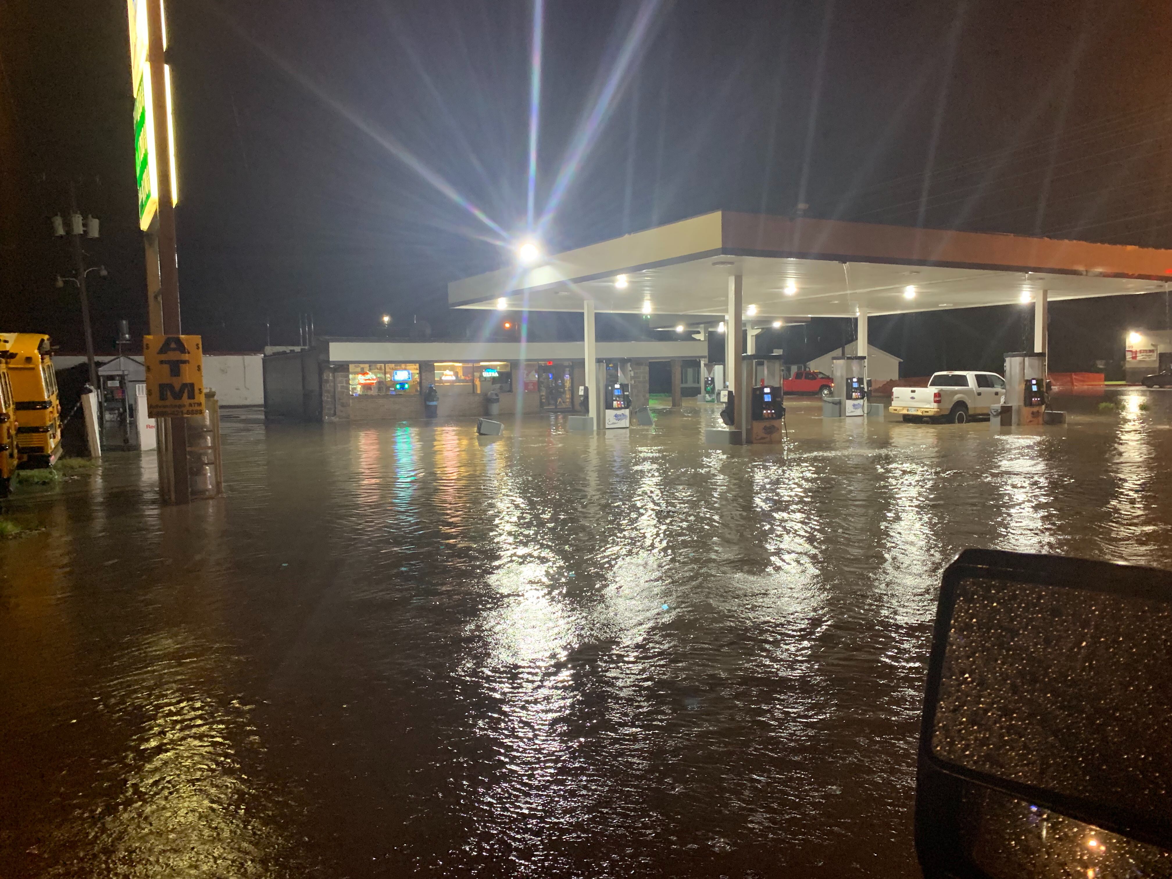
TWC saying boat rescues are happening in Hominy, OK... and they said something like 5 feet of water in some homes
if I heard correctly
TWC saying boat rescues are happening in Hominy, OK... and they said something like 5 feet of water in some homes
if I heard correctly
Posted on 5/20/19 at 11:41 pm to rt3
storm trying to hook back up as it approaches Bentonville?

Posted on 5/20/19 at 11:45 pm to rt3
Rotation in that storm approaching Norman?
Posted on 5/20/19 at 11:45 pm to rt3
Can you imagine if Walmart central systems went offline? That thing is so micromanaging it controls even the thermostats at each store remotely.
Posted on 5/20/19 at 11:46 pm to Pettifogger
quote:

Mesoscale Discussion 0717
NWS Storm Prediction Center Norman OK
1141 PM CDT Mon May 20 2019
Areas affected...western north Texas into central and northeastern
Oklahoma
Concerning...Tornado Watch 203...
Valid 210441Z - 210545Z
The severe weather threat for Tornado Watch 203 continues.
SUMMARY...The severe threat continues across WW 203
DISCUSSION...Storms have continued upscale growth into linear
segments - one over central Oklahoma from Logan to Grady Counties
and another couple of segments over western North Texas. Portions
of these segments are slightly elevated atop remnant cold pools from
earlier convection. At this time, the greatest severe threat
appears to be tied to convection that can ingest near surface-based
parcels and along the intersection of forward-propagating linear
segments and remnant outflow boundaries from earlier convection.
Storms continue in a moderately unstable and strongly sheared
environment, with a continued threat of hail, wind, and isolated
tornadoes through the next several hours.
..Cook.. 05/21/2019
Posted on 5/20/19 at 11:46 pm to rt3
Could be something brewing west of Ava, MO.
Posted on 5/20/19 at 11:48 pm to Sao
quote:
Can you imagine if Walmart central systems went offline? That thing is so micromanaging it controls even the thermostats at each store remotely.
damn... seriously?
Posted on 5/20/19 at 11:49 pm to rt3
quote:
NWS Tulsa @NWStulsa
[11:46 pm - 5/20/19] FLASH FLOOD EMERGENCY for parts of Tulsa, Rogers, Mayes, Wagoner counties. Widespread flooding is occurring and more heavy rainfall will move into these same areas soon. Move to higher ground if in a flood prone area! #okwx
Posted on 5/20/19 at 11:57 pm to rt3
quote:
damn... seriously?
Absolutely correct!
Posted on 5/21/19 at 12:20 am to GeauxGutsy
quote:
URGENT - IMMEDIATE BROADCAST REQUESTED
Tornado Watch Number 204
NWS Storm Prediction Center Norman OK
1220 AM CDT Tue May 21 2019
The NWS Storm Prediction Center has issued a
* Tornado Watch for portions of
Northern Arkansas
Southern Missouri
Eastern Oklahoma
* Effective this Tuesday morning from 1220 AM until 800 AM CDT.
* Primary threats include...
A couple tornadoes possible
Scattered damaging wind gusts to 70 mph possible
Isolated large hail events to 1.5 inches in diameter possible
SUMMARY...Periodic severe thunderstorms capable of mostly damaging
winds and some tornado risk will continue to favor a
southwest/northeast-oriented boundary through the overnight hours.
The tornado watch area is approximately along and 45 statute miles
north and south of a line from 10 miles north northeast of West
Plains MO to 20 miles north northwest of Mcalester OK. For a
complete depiction of the watch see the associated watch outline
update (WOUS64 KWNS WOU4).
PRECAUTIONARY/PREPAREDNESS ACTIONS...
REMEMBER...A Tornado Watch means conditions are favorable for
tornadoes and severe thunderstorms in and close to the watch
area. Persons in these areas should be on the lookout for
threatening weather conditions and listen for later statements
and possible warnings.
&&
OTHER WATCH INFORMATION...CONTINUE...WW 200...WW 201...WW
202...WW 203...
AVIATION...Tornadoes and a few severe thunderstorms with hail
surface and aloft to 1.5 inches. Extreme turbulence and surface wind
gusts to 60 knots. A few cumulonimbi with maximum tops to 550. Mean
storm motion vector 24030.
...Guyer
This post was edited on 5/21/19 at 12:27 am
Posted on 5/21/19 at 12:45 am to rt3
Posted on 5/21/19 at 1:14 am to rt3
Checking In from Edmond, OK. Little bit of rain in bunches. Not much despite the TWC telling me we’re in a flash flood watch. Craved something sweet and went to the Sonic around the corner. They were closed. Tough times lol.

Posted on 5/21/19 at 3:40 am to strohmile126
quote:
Craved something sweet and went to the Sonic around the corner. They were closed. Tough times lol.
Did you at least check knuckles with bum or crackhead on the street. A sonic visit should never be wasted.
Posted on 5/21/19 at 10:50 am to Sao
quote:
Wondering if Springfield, Mo. is going to see something tho
I live in Springfield, Lucas Oil Speedway in Wheatland got tore up pretty good and a coworker's husband and son got hurt pretty bad after their barn collasped on them.

 Page 30 of 31

Popular
Back to top