- My Forums
- Tiger Rant
- LSU Recruiting
- SEC Rant
- Saints Talk
- Pelicans Talk
- More Sports Board
- Coaching Changes
- Fantasy Sports
- Golf Board
- Soccer Board
- O-T Lounge
- Tech Board
- Home/Garden Board
- Outdoor Board
- Health/Fitness Board
- Movie/TV Board
- Book Board
- Music Board
- Political Talk
- Money Talk
- Fark Board
- Gaming Board
- Travel Board
- Food/Drink Board
- Ticket Exchange
- TD Help Board
Customize My Forums- View All Forums
- Show Left Links
- Topic Sort Options
- Trending Topics
- Recent Topics
- Active Topics
Started By
Message
re: Weather for Monday, May 20. Attention: N TX, Cen. OK, S KS High risk forecast
Posted on 5/20/19 at 4:08 pm to NorthEndZone
Posted on 5/20/19 at 4:08 pm to NorthEndZone
Looks like a cell is just going to pass north of Altus
But Blair is fricked
But Blair is fricked
 0
0

Posted on 5/20/19 at 4:10 pm to Scoop
big hook near Orlando, Ok.

Posted on 5/20/19 at 4:11 pm to Scoop

Posted on 5/20/19 at 4:11 pm to chinhoyang
quote:
big hook near Orlando, Ok.
that's the cell KFOR's helicopter's been on, which has at times had 2 tornadoes on the ground at once
Posted on 5/20/19 at 4:12 pm to rt3
Went back two pages and dont see a viewing link. Any help with a link?
Posted on 5/20/19 at 4:12 pm to rt3
that storm is fixing to meet it's demise heading for stable air.
Posted on 5/20/19 at 4:13 pm to NorthEndZone
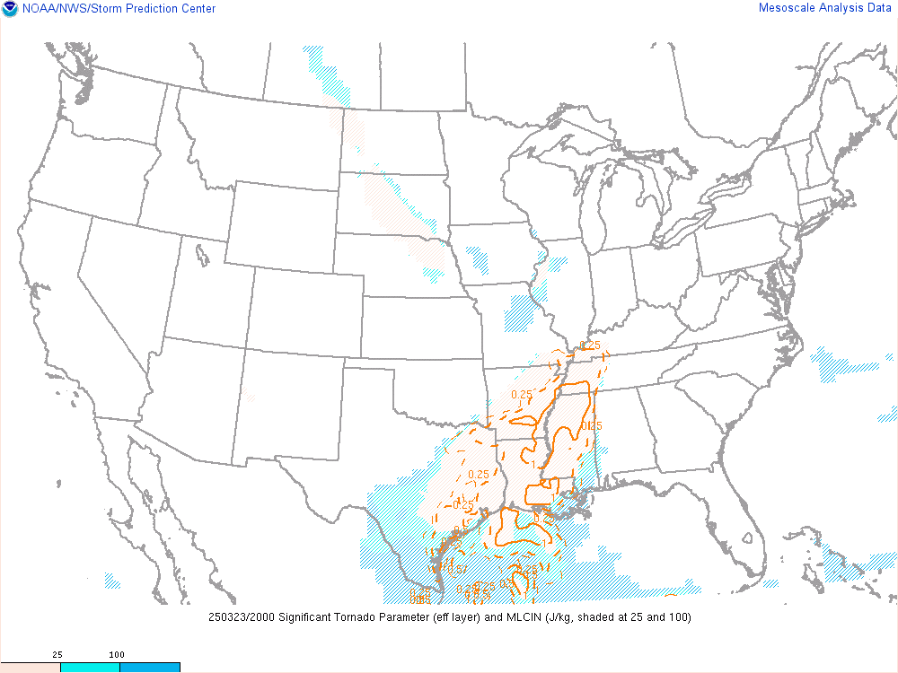
Significant Tornado Parameter of 10! 

Posted on 5/20/19 at 4:14 pm to lsurulz1515
Posted on 5/20/19 at 4:14 pm to lsurulz1515

Posted on 5/20/19 at 4:14 pm to Pepperoni
Childress cell has weakened a little but is still not crowded by anything. It may not be done.
Posted on 5/20/19 at 4:17 pm to Scoop
I'm thinking the back end is about to ramp up. Radar returns getting heavier and a little rotation might be getting going.
North and South might end up splitting.
North and South might end up splitting.
Posted on 5/20/19 at 4:20 pm to Duke
Yeah, the tail took a five minute breather and is firing back up.

Posted on 5/20/19 at 4:21 pm to theOG
Some of the more knowledgeable posters can give their thoughts on this, but storm mode is rather messy right now.
Posted on 5/20/19 at 4:21 pm to rt3
I expect this has been linked before but here are significant tornado parameters for now thru 84 hours in 3 hour intervals from Pivotal Weather. You can view it as loop or slides.
Significant Tornado Parameter Fixed Layer
Significant Tornado Parameter Fixed Layer
Posted on 5/20/19 at 4:25 pm to Pepperoni
Still calm here
Posted on 5/20/19 at 4:26 pm to Roll Tide Ravens
Velocity has been messy on RS all afternoon.
For obvious reasons, there are a lot of Dopplers in the area.
Just keep jumping around to find the best sigs.
For obvious reasons, there are a lot of Dopplers in the area.
Just keep jumping around to find the best sigs.

Posted on 5/20/19 at 4:28 pm to East Coast Band
Think itll be a no show for F4 or F5 activity?
Posted on 5/20/19 at 4:28 pm to Duke
It seems storms today haven’t been able to fully take advantage of conditions which is good.. I understand the overcrowding is having an impact on some the cells, but just curious if you had an opinion on this?
Posted on 5/20/19 at 4:31 pm to Scoop
I went ahead and pulled the trigger on Radar Scope.
Posted on 5/20/19 at 4:31 pm to SEClint
You may have a 3 or 4 out there right now south of Hollis.

 Page 20 of 31

Popular
Back to top