- My Forums
- Tiger Rant
- LSU Recruiting
- SEC Rant
- Saints Talk
- Pelicans Talk
- More Sports Board
- Fantasy Sports
- Golf Board
- Soccer Board
- O-T Lounge
- Tech Board
- Home/Garden Board
- Outdoor Board
- Health/Fitness Board
- Movie/TV Board
- Book Board
- Music Board
- Political Talk
- Money Talk
- Fark Board
- Gaming Board
- Travel Board
- Food/Drink Board
- Ticket Exchange
- TD Help Board
Customize My Forums- View All Forums
- Show Left Links
- Topic Sort Options
- Trending Topics
- Recent Topics
- Active Topics
Started By
Message
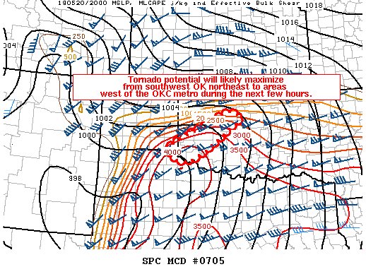
re: Weather for Monday, May 20. Attention: N TX, Cen. OK, S KS High risk forecast
Posted on 5/20/19 at 3:36 pm to Roll Tide Ravens

Posted on 5/20/19 at 3:36 pm to Roll Tide Ravens
Dirty looking hook is drawing out on the warned storm SE of Memphis Tx in the pan handle.
 1
1

Posted on 5/20/19 at 3:37 pm to Scoop
That'll have a warning on it soon. You're watching the same areas I am. Panhandle of TX into SW Oklahoma.
Posted on 5/20/19 at 3:38 pm to WinnPtiger
That’s about to form
Posted on 5/20/19 at 3:40 pm to StraightCashHomey21
That storm viewed from the chopper on KFOR is a monster.
This post was edited on 5/20/19 at 3:41 pm
Posted on 5/20/19 at 3:41 pm to Duke
Yeah.
Still fighting off all the messy velocity sigs.
This is difficult hunting.
Still fighting off all the messy velocity sigs.
This is difficult hunting.
Posted on 5/20/19 at 3:44 pm to Scoop
can you link me

Posted on 5/20/19 at 3:45 pm to Scoop
Holy shite.
Posted on 5/20/19 at 3:46 pm to Scoop
this storm on KFOR is still trying to put down 2 tornadoes at once

Posted on 5/20/19 at 3:46 pm to HogX
damn
those are both good sized
those are both good sized
Posted on 5/20/19 at 3:47 pm to rt3
Those things are huge
Posted on 5/20/19 at 3:47 pm to rt3
2 tornadoes on the ground half a mile apart from each other on KFOR
Posted on 5/20/19 at 3:47 pm to Duke
There is a good bit of crowding helping out the panhandle right now but that warned cell around Childress right now has some breathing room and is out by itself. That one is looking pretty solid.

Posted on 5/20/19 at 3:47 pm to StraightCashHomey21
quote:
Those things are huge
that's what I said

Posted on 5/20/19 at 3:47 pm to StraightCashHomey21

Posted on 5/20/19 at 3:48 pm to Scoop

Using RadarScope you can see radar image of reflectivity vs velocity of storms near Memphis. This shows confirmed tornado near Childress
Posted on 5/20/19 at 3:49 pm to Pepperoni
Posted on 5/20/19 at 3:49 pm to Who_Dat_Tiger
just missing those houses.
Posted on 5/20/19 at 3:49 pm to StraightCashHomey21
Big ole wall cloud showing up on KFOR, but not actually seeing much of a tornado on the ground currently.
On TWC, so it's not a live feed fwiw.
On TWC, so it's not a live feed fwiw.
This post was edited on 5/20/19 at 3:50 pm
Posted on 5/20/19 at 3:49 pm to Who_Dat_Tiger
It’s gotten calm in Altus
Posted on 5/20/19 at 3:50 pm to lsuman25
debris flying on TWC

 Page 18 of 31

Popular
Back to top