- My Forums
- Tiger Rant
- LSU Recruiting
- SEC Rant
- Saints Talk
- Pelicans Talk
- More Sports Board
- Fantasy Sports
- Golf Board
- Soccer Board
- O-T Lounge
- Tech Board
- Home/Garden Board
- Outdoor Board
- Health/Fitness Board
- Movie/TV Board
- Book Board
- Music Board
- Political Talk
- Money Talk
- Fark Board
- Gaming Board
- Travel Board
- Food/Drink Board
- Ticket Exchange
- TD Help Board
Customize My Forums- View All Forums
- Show Left Links
- Topic Sort Options
- Trending Topics
- Recent Topics
- Active Topics
Started By
Message
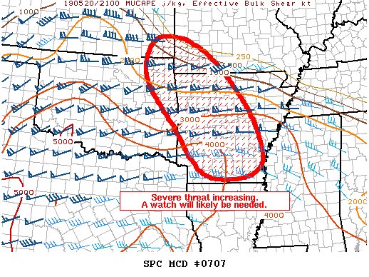
re: Weather for Monday, May 20. Attention: N TX, Cen. OK, S KS High risk forecast
Posted on 5/20/19 at 4:31 pm to Georgia Sooner 745
Posted on 5/20/19 at 4:31 pm to Georgia Sooner 745
circulation crossing I-35 in Oklahoma just west of Perry
 1
1

Posted on 5/20/19 at 4:32 pm to rt3
storm by Dover heading towards Hennessey, Okla. is getting its act together and starting to spin

Posted on 5/20/19 at 4:33 pm to Scoop
How does the cell south of Memphis, Tx not have a warning?
Big time couplet.
Big time couplet.
Posted on 5/20/19 at 4:35 pm to Georgia Sooner 745
quote:
I understand the overcrowding is having an impact on some the cells, but just curious if you had an opinion on this?
I'm not sure how much overcrowding is happening. There's the line riding the dry line on the west and the clusters on the warm front to the north.
There hasn't been much establishing it's self in the warm sector. Maybe the high winds aloft are just disrupting the baby updrafts, like the cell near Altus earlier.
More speculation than anything but makes enough sense.

Posted on 5/20/19 at 4:35 pm to StraightCashHomey21
I see that. Am just looking at Altus. Unless the stuff way sw of you keeps developing. About 140 miles away.
Posted on 5/20/19 at 4:36 pm to Scoop
Classic hook forming ok Hollis storm

Posted on 5/20/19 at 4:36 pm to Duke
Someone smarter than me check out Fayetteville, AR to my east. They’ve got a nasty one that popped up pretty quick with a bow.
Posted on 5/20/19 at 4:37 pm to Lsuhoohoo
quote:
I went ahead and pulled the trigger on Radar Scope.
Best thing you ever did, Clark
Posted on 5/20/19 at 4:38 pm to Scoop
Wtf are those 18 wheelers doing driving into the storm
Posted on 5/20/19 at 4:38 pm to Duke
Posted on 5/20/19 at 4:39 pm to Scoop
quote:
Best thing you ever did, Clark
Its soo much better than any of the free radar apps I've had. I'm streaming KFOR, reading through this thread and then checking those storms on the radar. I love being able to switch over to velocity.
Posted on 5/20/19 at 4:39 pm to Duke
I've been out of following this for a few hours. Has this lived up to the concern shown earlier? Or are these people catching a break?
Posted on 5/20/19 at 4:40 pm to Georgia Sooner 745
quote:
Classic hook forming ok Hollis storm
That cell has been the belle of the ball for almost an hour now.
It has to be the leader in the club house.
Posted on 5/20/19 at 4:41 pm to Lsuhoohoo
Northwest Arkansas could possibly see some tornadoes this evening. Whatever develops from here on out will have all the necessary ingredients. Warm front has lifted to our north.
Posted on 5/20/19 at 4:41 pm to LSUFanHouston
quote:
I've been out of following this for a few hours. Has this lived up to the concern shown earlier?
Not yet. Haven't seen the feared parade of supercells.
Long way to go though.
Posted on 5/20/19 at 4:41 pm to Scoop
We just missed that Hollis storm
Posted on 5/20/19 at 4:41 pm to Scoop
developing storm without any warning on it about to slam into Hennessey, Okla.
Posted on 5/20/19 at 4:42 pm to Scoop
It’s the only cell I’m watching now
Posted on 5/20/19 at 4:44 pm to Georgia Sooner 745
quote:
It’s the only cell I’m watching now
Gould, Okla. about to get fud up
Posted on 5/20/19 at 4:45 pm to Georgia Sooner 745
Altus in a tornado warning until 5:25

 Page 21 of 31

Popular
Back to top