- My Forums
- Tiger Rant
- LSU Recruiting
- SEC Rant
- Saints Talk
- Pelicans Talk
- More Sports Board
- Fantasy Sports
- Golf Board
- Soccer Board
- O-T Lounge
- Tech Board
- Home/Garden Board
- Outdoor Board
- Health/Fitness Board
- Movie/TV Board
- Book Board
- Music Board
- Political Talk
- Money Talk
- Fark Board
- Gaming Board
- Travel Board
- Food/Drink Board
- Ticket Exchange
- TD Help Board
Customize My Forums- View All Forums
- Show Left Links
- Topic Sort Options
- Trending Topics
- Recent Topics
- Active Topics
Started By
Message
Two strong tornadoes ongoing in Mississippi
Posted on 5/6/26 at 7:13 pm
Posted on 5/6/26 at 7:13 pm
One going towards Brookhaven and other south of Hattiesburg my internet is messy so cant share the warning graphics
 8
8

Posted on 5/6/26 at 7:23 pm to lsuman25
One gonna get close to Brookhaven
Headed right for Bassfield, of course
Headed right for Bassfield, of course

Posted on 5/6/26 at 7:24 pm to deltaland
quote:
ne gonna get close to Brookhaven Headed right for Bassfield, of course
That’s a corridor that I would never live in.
Posted on 5/6/26 at 7:27 pm to Roll Tide Ravens
Looks like a really nasty one is about to form just south of Greensboro AL. Looks likes it’s dumping a shitload of hail right now
Posted on 5/6/26 at 7:29 pm to BPTiger
quote:
Looks like a really nasty one is about to form just south of Greensboro AL. Looks likes it’s dumping a shitload of hail right now
Yeah, James Spann just showed a video of ping pong ball sized hail with that one, and the location of the video wasn’t even in the worst of the hail core.
Posted on 5/6/26 at 7:29 pm to BPTiger

Posted on 5/6/26 at 7:29 pm to lsuman25
Yup, one was close to my deer lodge
Posted on 5/6/26 at 7:33 pm to lsuman25
Hattiesburg, MS
76°F
Today
Hourly
10-Day
Radar
MinuteCast®
Monthly
Air Quality
Health & Activities
Logo for U.S. National Weather Service
Tornado Warning
Source: U.S. National Weather Service
Start
7:23 PM
Wednesday, 5/6
End
8:00 PM
Wednesday, 5/6
© OpenStreetMap
The National Weather Service in Jackson has issued a
* Tornado Warning for... Northeastern Forrest County in southeastern Mississippi...
* Until 800 PM CDT.
* At 723 PM CDT, a tornado producing storm was located near McLaurin, or 7 miles south of Hattiesburg, moving northeast at 30 mph.
HAZARD...Damaging tornado and golf ball size hail.
SOURCE...Radar confirmed tornado.
IMPACT...Flying debris will be dangerous to those caught without shelter. Mobile homes will be damaged or destroyed. Damage to roofs, windows, and vehicles will occur. Tree damage is likely.
* This tornadic storm will be near... Hattiesburg, Sunrise, and McLaurin around 730 PM CDT.
PRECAUTIONARY/PREPAREDNESS ACTIONS...
To repeat, a tornado is on the ground. TAKE COVER NOW! Move to a basement or an interior room on the lowest floor of a sturdy building. Avoid windows. If you are outdoors, in a mobile home, or in a vehicle, move to the closest substantial shelter and protect yourself from flying debris.
Posted on 5/6/26 at 7:39 pm to lsuman25
Did they confirm touchdown?

Posted on 5/6/26 at 7:41 pm to lsuman25
Max Velocity weather live coverage
This post was edited on 5/6/26 at 7:42 pm
Posted on 5/6/26 at 7:42 pm to JasonDBlaha
quote:
Did they confirm touchdown?
The Meadville one was a no doubter significant tornado with a Tornado Emergency.
Posted on 5/6/26 at 7:43 pm to LegendInMyMind
One on the ground just southwest of Brookhaven now
Posted on 5/6/26 at 7:43 pm to Riseupfromtherubble
Yep. That storm cycled. They made it a PDS warning for Brookhaven. Tor Emergency likely coming if it holds together.
This post was edited on 5/6/26 at 7:45 pm
Posted on 5/6/26 at 7:47 pm to LegendInMyMind
Big debris ball on the one heading towards Monticello
Posted on 5/6/26 at 7:52 pm to razorbackfan4life
Gonna miss Brookhaven just to the south.
Posted on 5/6/26 at 7:53 pm to LegendInMyMind
quote:
The Meadville one was a no doubter significant tornado with a Tornado Emergency.
I’m in NW Amite county. There was one on the ground in Franklin county headed into amite a few minutes ago. Just windy with lots of thunder and lightning right now. We are the new tornado alley.
Posted on 5/6/26 at 7:56 pm to LegendInMyMind
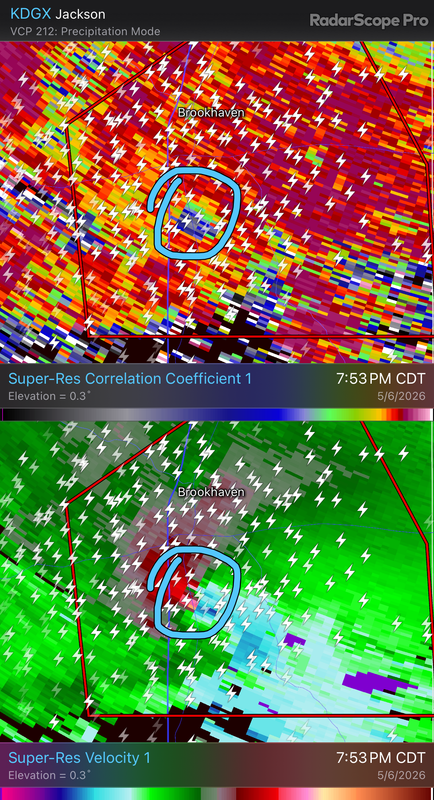
TDS on the Brookhaven, MS tornado.
Posted on 5/6/26 at 7:57 pm to Roll Tide Ravens
Storm chasers on the ground in the link I posted. Lot of trees down on 55
Posted on 5/6/26 at 7:58 pm to Riseupfromtherubble
Tornado emergency now - Thayer, MS just south of Brookhaven
Posted on 5/6/26 at 7:59 pm to pdubya76
We are the new tornado alley.
_____________________
it sure seems that way lately
_____________________
it sure seems that way lately

 Page 1 of 4

Popular
Back to top