- My Forums
- Tiger Rant
- LSU Recruiting
- SEC Rant
- Saints Talk
- Pelicans Talk
- More Sports Board
- Fantasy Sports
- Golf Board
- Soccer Board
- O-T Lounge
- Tech Board
- Home/Garden Board
- Outdoor Board
- Health/Fitness Board
- Movie/TV Board
- Book Board
- Music Board
- Political Talk
- Money Talk
- Fark Board
- Gaming Board
- Travel Board
- Food/Drink Board
- Ticket Exchange
- TD Help Board
Customize My Forums- View All Forums
- Show Left Links
- Topic Sort Options
- Trending Topics
- Recent Topics
- Active Topics
Started By
Message
re: Two strong tornadoes ongoing in Mississippi
Posted on 5/6/26 at 8:00 pm to NorthEndZone
Posted on 5/6/26 at 8:00 pm to NorthEndZone
It’s headed NE out of Brookhaven and headed to Monticello. Was this the tornado that was In Meadville?
This post was edited on 5/6/26 at 8:01 pm
 2
2

Posted on 5/6/26 at 8:01 pm to pdubya76
quote:
I’m in NW Amite county. There was one on the ground in Franklin county headed into amite a few minutes ago. Just windy with lots of thunder and lightning right now. We are the new tornado alley.
This was the best window for this setup to produce tornadoes. The front coming down from the north progressed faster than modeled, limiting the severe threat for the northern extent. Had the storm in the Montgomery area earlier today try everything to produce, but just couldn't get it done. The LLJ kicked in, and in what remained of the warm sector those storms still hanging around got a boost.
There have been some big hailers in southern AL today, as well.
This post was edited on 5/6/26 at 8:04 pm
Posted on 5/6/26 at 8:02 pm to pdubya76
quote:
Was this the tornado that was In Meadville?
Different tornado, same storm. It cycled and produced this one.
Posted on 5/6/26 at 8:05 pm to pdubya76
Isn’t Monticello south of Brookhaven
Posted on 5/6/26 at 8:05 pm to LegendInMyMind
You can look at the traffic on i55 and tell where it crossed. Dead stopped.
Posted on 5/6/26 at 8:07 pm to CypressTrout10
Is there still the GP Paper Mill in Monticello?

Posted on 5/6/26 at 8:07 pm to lsuman25
Severe Weather Statement
National Weather Service Jackson MS
805 PM CDT Wed May 6 2026
MSC065-077-085-070200-
/O.CON.KJAN.TO.W.0037.000000T0000Z-260507T0200Z/
Lincoln MS-Lawrence MS-Jefferson Davis MS-
805 PM CDT Wed May 6 2026
...TORNADO EMERGENCY FOR Monticello, Silver Creek...
...A TORNADO WARNING REMAINS IN EFFECT UNTIL 900 PM CDT FOR
NORTHEASTERN LINCOLN...LAWRENCE AND WESTERN JEFFERSON DAVIS
COUNTIES...
At 804 PM CDT, a confirmed large and destructive tornado was located
near Enterprise, or near Brookhaven, moving east at 35 mph.
TORNADO EMERGENCY for Monticello, Silver Creek. This is a
PARTICULARLY DANGEROUS SITUATION. TAKE COVER NOW!
HAZARD...Deadly tornado.
SOURCE...Radar confirmed tornado.
IMPACT...You are in a life-threatening situation. Flying debris may
be deadly to those caught without shelter. Mobile homes
will be destroyed. Considerable damage to homes,
businesses, and vehicles is likely and complete destruction
is possible.
The tornado will be near...
East Lincoln around 810 PM CDT.
Sontag around 815 PM CDT.
Monticello and Wanilla around 820 PM CDT.
Silver Creek around 830 PM CDT.
Oma around 835 PM CDT.
New Hebron around 840 PM CDT.
PRECAUTIONARY/PREPAREDNESS ACTIONS...
To repeat, a large, extremely dangerous, and potentially deadly
tornado is on the ground. To protect your life, TAKE COVER NOW! Move
to an interior room on the lowest floor of a sturdy building. Avoid
windows. If in a mobile home, a vehicle or outdoors, move to the
closest substantial shelter and protect yourself from flying debris.
&&
Posted on 5/6/26 at 8:08 pm to Pisco
Likely a multi-vortex tornado at the moment. Two clear couplets.
Posted on 5/6/26 at 8:10 pm to LegendInMyMind
Supercell of the year so far crazy arse storm
Posted on 5/6/26 at 8:14 pm to LegendInMyMind
Holy shite it’s getting bigger. You can see the size of it on velocity
Posted on 5/6/26 at 8:16 pm to CypressTrout10
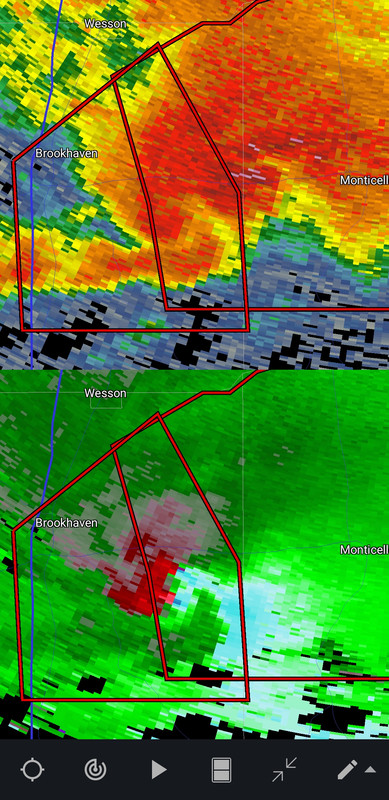
Debris ball now on Reflectivity.
Posted on 5/6/26 at 8:16 pm to lsuman25

Posted on 5/6/26 at 8:24 pm to Chad504boy
More east down highway 84.
Not northeast haha. Good catch.
Not northeast haha. Good catch.
This post was edited on 5/6/26 at 8:26 pm
Posted on 5/6/26 at 8:26 pm to pdubya76
quote:
Severe Weather Statement
National Weather Service Jackson MS
825 PM CDT Wed May 6 2026
MSC065-077-070200-
/O.CON.KJAN.TO.W.0037.000000T0000Z-260507T0200Z/
Lawrence MS-Jefferson Davis MS-
825 PM CDT Wed May 6 2026
...TORNADO EMERGENCY FOR Monticello, Silver Creek...
...A TORNADO WARNING REMAINS IN EFFECT UNTIL 900 PM CDT FOR LAWRENCE
AND WESTERN JEFFERSON DAVIS COUNTIES...
At 824 PM CDT, a confirmed large and destructive tornado was located
near Monticello, moving east at 30 mph.
TORNADO EMERGENCY for Monticello, Silver Creek. This is a
PARTICULARLY DANGEROUS SITUATION. TAKE COVER NOW!
HAZARD...Deadly tornado.
SOURCE...Radar confirmed tornado.
IMPACT...You are in a life-threatening situation. Flying debris may
be deadly to those caught without shelter. Mobile homes
will be destroyed. Considerable damage to homes,
businesses, and vehicles is likely and complete destruction
is possible.
The tornado will be near...
Monticello, Silver Creek, Wanilla, Robinwood, and Arm around 830
PM CDT.
Progress around 835 PM CDT.
.png)
Posted on 5/6/26 at 8:26 pm to Roll Tide Ravens
quote:
TDS
You’ve been talking too much politics
Posted on 5/6/26 at 8:28 pm to sorantable
Monticello may have just caught a huge break. The rotation broadened abruptly on the latest scan.
Posted on 5/6/26 at 8:28 pm to sorantable
Timmer is heading south onto MS 27 from US 84 to try an intercept.
Posted on 5/6/26 at 8:33 pm to NorthEndZone
Let's see if this debris is just debris that has been lofted and is cycling out. I think it dissipated/lifted just before getting into Monticello.
There is no strong couplet, and it looks more outflow dominant right now.
There is no strong couplet, and it looks more outflow dominant right now.
This post was edited on 5/6/26 at 8:35 pm
Posted on 5/6/26 at 8:36 pm to LegendInMyMind
That said, it still has a decent inflow notch and could reform to the NE of Monticello.

 Page 2 of 4

Popular
Back to top