- My Forums
- Tiger Rant
- LSU Recruiting
- SEC Rant
- Saints Talk
- Pelicans Talk
- More Sports Board
- Coaching Changes
- Fantasy Sports
- Golf Board
- Soccer Board
- O-T Lounge
- Tech Board
- Home/Garden Board
- Outdoor Board
- Health/Fitness Board
- Movie/TV Board
- Book Board
- Music Board
- Political Talk
- Money Talk
- Fark Board
- Gaming Board
- Travel Board
- Food/Drink Board
- Ticket Exchange
- TD Help Board
Customize My Forums- View All Forums
- Show Left Links
- Topic Sort Options
- Trending Topics
- Recent Topics
- Active Topics
Started By
Message
re: TS Elsa - Heading off to the NE, Then Shut the Tropics Down for a Couple of Weeks
Posted on 6/24/21 at 1:27 pm to rt3
Posted on 6/24/21 at 1:27 pm to rt3
So Saharan dust/sand is good but the Saharan hot air currents are bad?
I watched that thing tying in the dust particles keeping the Amazon fertile. That was wild. Think they are heavy on the nitrogen and potassium particles or something. Fascinating stuff.
I watched that thing tying in the dust particles keeping the Amazon fertile. That was wild. Think they are heavy on the nitrogen and potassium particles or something. Fascinating stuff.
 1
1

Posted on 6/24/21 at 2:03 pm to Abstract Queso Dip
It's the dryness of the air that cuts the legs out of a tropical system.
Water vapor gives up it's latent heat when it condenses and that heat is what a hurricane eats. Dry air leads to evaporation, which sucks the energy out of the storm.
Water vapor gives up it's latent heat when it condenses and that heat is what a hurricane eats. Dry air leads to evaporation, which sucks the energy out of the storm.
Posted on 6/24/21 at 2:13 pm to The Boat
Jaxson and Aiden are gonna be pissed if World Series in Panama City gets rained out.
Posted on 6/25/21 at 7:07 am to rds dc
Any updates?
Posted on 6/25/21 at 7:49 am to Riolobo
They backed off development changes from 40% to 20%
Marginally conducive environment over next few days
Nothingburger
Marginally conducive environment over next few days
Nothingburger
Posted on 6/25/21 at 7:53 am to deltaland
As this gets closer to the Caribbean it should hit some pretty bad shear. Even if something managed to form, I’m not sure how much would be left of it when it gets closer to the US.
Posted on 6/25/21 at 8:00 am to rds dc
quote:
quote:
Nothingburger
quote:
That's the safe bet for this time of year.
Hard to beat climo this time of year. Also, it looks like the model bias of jumpstarting AEW right of Africa is still there.
Posted on 6/26/21 at 5:35 pm to rds dc
quote:
Hard to beat climo this time of year.
Climo does become more favorable as 95L works westward.
NHC has bumped 95L back to 30% through D5.

Ensembles are starting to pickup as this approaches the Islands and tracks westward.

And the HWRF is doing HWRF things

Posted on 6/26/21 at 6:41 pm to rds dc
quote:
Ensembles are starting to pickup as this approaches the Islands and tracks westward.
Remember how we talked about wanting things to form sooner...

Posted on 6/26/21 at 7:26 pm to Duke
quote:
NWS GSP
@NWSGSP
@NHC_Atlantic is following two disturbances across the Atlantic Basin. The closest one has a 10 percent chance of forming in the next 5 days. Whether or not it becomes a named storm, it may bring isolated heavy rain Cloud with rain to the area early next week.

Posted on 6/26/21 at 7:39 pm to Duke
In Turks & Caicos right now. ETA on when we should start paying attention?
Posted on 6/26/21 at 7:43 pm to LSUGrrrl
95L looks a good week away from the Lesser Antilles, so another few days after that for you.
If you're still having to worry about it 10 days from now, I'm jealous.
If you're still having to worry about it 10 days from now, I'm jealous.
Posted on 6/27/21 at 1:40 pm to Duke
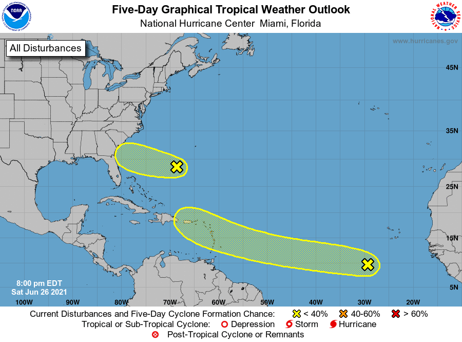
96L trying to make a run at it.
1. Satellite imagery and nearby buoy and ship observations indicate
that a small low pressure system has formed about 500 miles
east-southeast of the Georgia-South Carolina border. Surface
pressures have begun to fall across the area, and showers and
thunderstorms have recently become better organized. Some additional
development of this system will be possible later today, and
especially on Monday when the system will move across the warmer
waters of the Gulf Stream, and a tropical depression could form
before the system makes landfall along the southern U.S. coast. The
low is expected to move westward today, and then west-northwestward
at about 15 mph on Monday, reaching the coast of the southeastern
United States by late Monday. An Air Force Reserve Unit
reconnaissance aircraft is scheduled to investigate the system
Monday afternoon, if necessary.
* Formation chance through 48 hours...medium...50 percent.
* Formation chance through 5 days...medium...50 percent.
Posted on 6/27/21 at 1:54 pm to rds dc
Would Fred Flintstone be considered a baw?

Posted on 6/27/21 at 1:57 pm to rds dc
The front in the gulf plus the system I the west will come through and sweep that out.
Posted on 6/27/21 at 2:03 pm to dukke v
quote:
The front in the gulf plus the system I the west will come through and sweep that out.
frick you for jinxing us you old frick.
Posted on 6/27/21 at 2:08 pm to Tornado Alley
quote:
frick you for jinxing us you old frick.


Posted on 6/27/21 at 2:11 pm to rds dc
It’s gonna be another fake early season Carolina storm. This was the one last year. Check out those winds.


 Page 6 of 49

Popular
Back to top